|

|
SPECIAL ISSUE - MapPoint 2004 - Technology and Applications
|

|
MapPoint 2004
A Special Issue on the Applications,
Technology, and Partners of Microsoft MapPoint
The desktop mapping
market welcomed a new entry in 1998 with the arrival of Microsoft MapPoint
2000. Directions Magazine believed that it represented a radical
shift in ease of use with a very low price point. So we created a "spin-off"
publication called MP2Kmag.
Here, now, we present the technology and applications associated with
the latest version of the product, MapPoint 2004. In addition, we are providing
a section on the group of worldwide partners that Microsoft has recruited
to develop on the MapPoint platform. Microsoft enticed the partners because
MapPoint takes advantage of the component object model (COM) architecture.
As MapPoint migrates to a .NET environment, unique applications for wireless
and Web services are emerging. We are pleased to present you with this issue
to keep you apprised of the latest developments.
Thanks for reading Directions Magazine, and be sure
to tell a friend!
Nora Parker, Senior Managing Editor
|
|
|
|
|
|
|
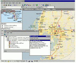
MapPoint 2004 Product Overview
|
|
|
A Note from Michael
Graff
General Manager for Microsoft’s
MapPoint Business Unit

I’m pleased to introduce this
special edition of Directions Magazine dedicated to the latest
release of our business analysis and visualization software, Microsoft® MapPoint® North
America and Microsoft® MapPoint® European Edition.
Since MapPoint was first introduced
in 1998, our team has worked hard to provide you with high-quality maps,
the latest demographic data and increasingly intuitive visualization tools
— all at a great value right out of the box. We hope that you share our enthusiasm
as you read on and learn more about the new and enhanced features. To try the features out for yourself, we invite you to
order the trial
version available now.
New Providers for Better Data
Visualization
MapPoint contains updated maps
and demographic data in the North American and European 2004 versions to help you visualize and communicate your business
information with accurate, detailed data. The most notable additions
to the data revolve around fresh business-related demographic and consumer
profile data for the United States, sourced from two premier data partners:
•Applied
Geographic Solutions, Inc. (AGS) has supplied more than 100 core
demographic data variables, including population totals, population ages,
house values, commuter information, weather, education levels and household
information (such as income, family size and computer usage). Incorporate
these demographics to enhance analysis of your own business data or to narrow
down a business opportunity.
•Simmons detailed U.S.
consumer purchase behavior data provides information on the lifestyles, media
behavior, product purchases and brand preferences of the United States consumer.
MapPoint is the first and only place that Simmons data is available at the
low level geographies offered in MapPoint, including shopping habits, credit card
use and television services. With Simmons data, you
can compare your business information with consumer purchase behavior to
reveal the best location for a new store or the best place to target your
marketing efforts.
Though MapPoint contains hundreds
of variables, you may want to purchase data that does not come with MapPoint.
Both AGS and Simmons offer MapPoint users the ability
to purchase supplemental demographic variables and updates and then import
and map this data in MapPoint.
Features and Functions for
Clearer Business Communication
The maps in the
product have been updated to provide you with accurate, current street data,
which includes
6.7 million miles of roads in the North American version and 4.3 million kilometers of roads in the European version.
The map of Europe now contains updated municipal geographic boundaries, address-finding
capabilities and detailed street network data in Sweden, Portugal, Norway
and Finland. This makes it easier than ever to view
your business data within geographic boundaries that matter most to your
company.
Now both MapPoint 2004 and
Pocket Streets, which ships with MapPoint, support the real-time global positioning
system (GPS) and a wider range of GPS devices than ever before (includes
almost any device running NMEA 0183 version 2.0 or later on COM Port 20
or below.) You simply plug your GPS device into a laptop running MapPoint
or your Pocket PC running Microsoft Pocket Streets, and the products synchronize
your position and let you see your location on-screen. This
makes finding your location on the map easy and accurate. Both MapPoint
and Pocket Streets now check the GPS device for location information every
second.
You can easily find the closest
restaurant, hotel or cash machine with enhanced business listings and points
of interest. The North American version contains more
than 1.4 billion restaurants, hotels, service stations, cash machines,
etc., while the European version tallies more than 400,000 points of interest.
MapPoint 2004 users will benefit
from a range of usability enhancements that make everyday experience with
MapPoint better. Take advantage of more accurate and
easier-to-understand driving directions at complicated intersections and
on routes that require several quick turns in a row.
The ability to print full-page maps and arrows
on the map indicating one-way streets also makes MapPoint easier to use.
Sixty new pushpin symbols (used to designate specific map locations) have
been added to the hundreds already available. As in
the last version, you can create our own customized pushpin symbols of your
company’s logo or brand so that you have the symbols you need.
Have more questions about what
MapPoint 2004 offers? Our list of Frequently Asked
Questions and detailed tutorials
can help.
Developers
Have More Options
Developers can build MapPoint
solutions in three ways. First, you can write an extension
that adds new functionality to MapPoint using automation and COM Add-ins.
This new functionality usually appears as a new menu item. You can also
write applications that automate MapPoint, such as a Word macro to automatically
drop a map into a document. And lastly, you can write
an application that embeds MapPoint into your own application using automation
and the MapPoint ActiveX® control.
Now
using one or more of the programming approaches explained above, developers
can take advantage of the new and enhanced features for developers in MapPoint
2004. These features include getting a location from a United Kingdom Ordinance
Survey Grid reference string, registering COM add-ins for all users of a
machine (use HKEY_LOCAL_MACHINE for all users or HKEY_CURRENT_USER just for
current user), and automating full-page map printing through the application
programming interface (API). MapPoint now also integrates better with Microsoft
Visual Studio® .NET, which means easier creation of MapPoint COM Add-ins
and automatic recognition of MapPoint in the Visual Studio wizard.
If you’re a developer, please
read MapPoint’s MSDN Magazine article by Steve Lombardi about the different ways to use MapPoint
2004 within your application. This article also explains
the difference between the MapPoint Web Service and MapPoint 2004.
|
|
|
|
|
|
|
MapPoint 2004 Partners and Applications
|
|
|
MapPoint aims to provide you
with everything you need to get started doing everyday business mapping and
analysis by including powerful data and analysis tools right in the box.
If, however, you want a solution created specifically for your business’
special requirements, MapPoint partners can help. Below
are partners that specialize in creating applications for everything from
fleet management to criminal investigation. Some partners
sell data, while others can help you integrate MapPoint into your contact
management tool. Please read more about North American
and European MapPoint partners.
North American
Partners
High quality demographic
data products and the lifestyle segmentation system, Mosaic
AGS delivers an extensive range of
the highest quality demographic data products and lifestyle segmentation
system, MOSAIC™. All databases are derived from superior source data and
the most sophisticated, refined, and proven methodologies. The vast majority
of AGS' market leading databases are available down to the block group levels.
AGS databases include census data, estimates and projections, Consumer Expenditures,
Mediamark Consumer Behavior, Insource Consumer Profiles, BusinessCounts
daytime population, Assets & Debts / Net Worth, CrimeRisk, WeatherRisk,
climate, Puerto Rico data, MOSAIC™ segmentation, retail potential, computer
ownership and Internet usage, and Demographic Dimensions.
Applications for the
contracting industry, commercial, residential, industrial, institutional
as well as installation and service contractors
The ACOWIN
for Windows Dispatch Board offers seamless integration with Microsoft's
Map Point© mapping software. With the ACOWIN Mapping interface and
Microsoft Map Point© installed on your computer, the dispatcher will
be able to instantly view a map of any worksite, or even pull up a route
map of a technician's schedule for the day from the Dispatch Board with a
click of the mouse. The powerful combination of Microsoft Map Point©
and the ACOWIN Dispatch Board can help you to minimize the travel time
and keep your technicians on the job sites, generating income!
A MapPoint
solution for today's GIS demands
Cruiser Software’s Data2Map manages
a complex, geo-spatial data store with the ease and elegance of Microsoft's
MapPoint rendering engine. With the Data2Map solution, the flexibility and
power of GIS found in today's sophisticated mapping engines, is now available
for MapPoint. Data2Map breaks through the limitations of MapPoint by managing
an unlimited number of shapes and pushpins, providing layer control, allowing
data-dependent symbology and full-featured data management. Bridging the
gap between the technical demands of GIS and the easy-to-use Microsoft Office
product, Data2Map meets the needs of those companies that require the
mapping of large, complex datasets, but lack the means required for deploying
a more traditional mapping engine.
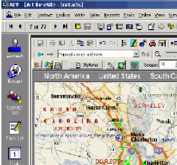
Integrated site assessment solutions
ActMap is an add-on for ACT! From eSite, Inc., which integrates
MapPoint with the popular ACT! contact management software. Data can be moved
either from ACT! Into MapPoint or from MapPoint into ACT! The result is
the full power of both applications to leverage ACT!’s complete range of
relational database features and all of MapPoint’s power to help analyze,
route, plan and review any data which is geo-referenced. Some examples of
its use include Sales and Sales Management, Warehouse Delivery, Public Health,
Data mining - the list is endless.
Crime analysis
solutions to law enforcement professionals
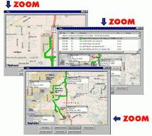
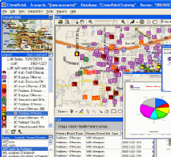 Forensic Logic, Inc.'s application, CrimePoint, is used to more rapidly
detect criminal suspects and identify areas of high criminal incidence
for the law enforcement and public safety industry. Configured as a standalone
workstation application, a turnkey hardware/software solution or a powerful
integrated client/server system, CrimePoint is used by local, state and
federal law enforcement agencies throughout North America. CrimePoint incorporates
sophisticated data management techniques based on Microsoft SQL Server,
robust geographic information mapping based on MapPoint and proprietary
criminal behavioral algorithms developed over a 25 year period.
Forensic Logic, Inc.'s application, CrimePoint, is used to more rapidly
detect criminal suspects and identify areas of high criminal incidence
for the law enforcement and public safety industry. Configured as a standalone
workstation application, a turnkey hardware/software solution or a powerful
integrated client/server system, CrimePoint is used by local, state and
federal law enforcement agencies throughout North America. CrimePoint incorporates
sophisticated data management techniques based on Microsoft SQL Server,
robust geographic information mapping based on MapPoint and proprietary
criminal behavioral algorithms developed over a 25 year period.
Fleet management
solutions
 Having quality maps is essential for a fleet manager to pinpoint activity
and optimize operations and GEOTAB
and Microsoft MapPoint 2004 are a powerful combination for businesses
operating with fleet vehicles. GEOTAB is the only GPS system that
uses dynamic processing of GPS data to calculate distance driven within OEM
distance requirements. This enables GEOTAB to spread its use across several
levels within an organization thus making GEOTAB a growth foundation for
fleet and outside operations business management. GEOTAB offers
solutions for North America and Europe.
Having quality maps is essential for a fleet manager to pinpoint activity
and optimize operations and GEOTAB
and Microsoft MapPoint 2004 are a powerful combination for businesses
operating with fleet vehicles. GEOTAB is the only GPS system that
uses dynamic processing of GPS data to calculate distance driven within OEM
distance requirements. This enables GEOTAB to spread its use across several
levels within an organization thus making GEOTAB a growth foundation for
fleet and outside operations business management. GEOTAB offers
solutions for North America and Europe.
Online library of commercial earth
imagery; customer
 GlobeXplorer’s ImageConnect is a unique mapping
application extension that can instantly retrieve satellite and aerial photos
into a user’s web application, desktop, or mobile device from GlobeXplorer's
online aerial image database. ImageConnect takes away the time, cost and
hassle of locating an image provider, waiting for delivery, and managing
large image files. Using ImageConnect, and its core programming toolkit,
ImageBuilder, MapPoint.NET developers and users can connect directly to
GlobeXplorer’s global online imagery server and pull aerial photos directly
into their online project. Developing dynamic
web applications that include aerial and satellite imagery has never been
easier.
GlobeXplorer’s ImageConnect is a unique mapping
application extension that can instantly retrieve satellite and aerial photos
into a user’s web application, desktop, or mobile device from GlobeXplorer's
online aerial image database. ImageConnect takes away the time, cost and
hassle of locating an image provider, waiting for delivery, and managing
large image files. Using ImageConnect, and its core programming toolkit,
ImageBuilder, MapPoint.NET developers and users can connect directly to
GlobeXplorer’s global online imagery server and pull aerial photos directly
into their online project. Developing dynamic
web applications that include aerial and satellite imagery has never been
easier.
Product
development, software integration, consulting and business solutions such
as Microsoft CRM and MapPoint.
MapLinX Pro from LinXoft Solutions, Inc. is an
add-on query tool that is seamlessly integrated with MapPoint. The product
is designed to meet the needs of any sized business, whether you are a single
proprietary user or part of a large-scale enterprise it can help you provide
business intelligence capabilities including the ability to geocode, query,
map and analyze corporate information upon virtual maps. The intuitive
and user-friendly interface of MapLinX Pro makes it easy for the users
to manage their own map layers from various data sources. Developers can
write MapPoint-based applications that make API calls to MapLinX Pro to
leverage its capabilities.
Map-In-A-Box™ seamlessly
integrates MapPoint® 2004
functionality into MapInfo Professional™ or ArcGIS™
Map-In-A-Box
brings the best of both worlds together….MapInfo Professional or ArGIS and
Microsoft MapPoint 2004. Street level mapping has never been easier. Batch
geocoding to street number brings your addresses to life and can be used
in MapInfo Professional or ArcGIS. Drive time polygons can be created as
a new vector layer. The ‘Info Tool’ will give you reverse geocoding functionality.North
American and European Editions are available.
Geographically
based products and services
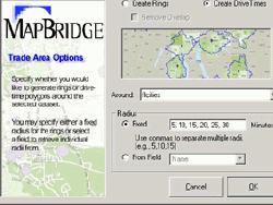
MapBridge is an easy-to-use
addition to MapPoint from Mapping Analytics that spans the
functionality of two powerful applications, Microsoft MapPoint version 2004
and SRC Allocate™ version 5.5. Allocate is the leading data retrieval
engine that compresses, stores, manages, retrieves and displays geographically
organized data. The data can include demographic attributes, customer data
or any data that can be organized into standard census or postal geographies.
Allocate also allows users to store custom geographic or geometric areas,
such as trade areas or sales territories, then obtain data for those areas
in just seconds.

Application software development utilizing GPS, GIS,
MapPoint and Wireless Communication Technologies
GPSTrackP is a low-cost
vehicle tracking and management system from Mobile GPS Online, a mobile GPS
products and services firm specializing in system integration and application
software design and development utilizing GPS, MapPoint and wireless communication
technologies. GPSTrackP uses GPS data loggers to collect tracking data, and
then display, analyze, and report the tracking data through a powerful software
tool based on Microsoft MapPoint technology. It is not a real-time tracking
system, but it offers a powerful tool to manage your most valuable business
assets vehicle and drivers in a most efficient way at a lowest possible
cost.

Driving directions
and location based services web applications
NAC Geographic Products, Inc. has developed a revolutionary technology
– the Natural Area Coding System and its derived systems (the Global Postal
Code System, the Universal Address System, the Universal Map Grid System
and the Universal Property Identifier System). This technology has unified
addresses, postal codes, area codes, map grid coordinates, geographic coordinates
and property identifiers in the world into standard and highly efficient
codes called Natural Area Codes (NACs). Using NACs can reduce by more than
80% the number of characters that are needed to communicate locations. This
revolutionary technology integrated with Microsoft MapPoint Web Service
has resulted in the world most efficient and powerful location based service
web applications: TravelGIS Driving Directions Service.
Business intelligence
software
 The
Panorama NovaView business intelligence platform enables companies
to rapidly deploy analytic and reporting solutions and build customized BI
applications. These solutions provide the relevant information and proactive
intelligence needed to make the best decisions and generate great results.
The NovaView platform is comprised of a scalable, high performance web application
server, easy to use client interfaces, robust analytics and report management
services. Panorama’s NovaView BI platform is uniquely optimized for Microsoft® Analysis
Services and Microsoft® Office Systems and can deliver
access or analyze data from any back end database, including leading vendors
such as Oracle, IBM, Microsoft, Teradata and others. NovaView PinPoint for
Microsoft MapPoint projects data stored in Microsoft Analysis Services
cubes onto geographical maps.
The
Panorama NovaView business intelligence platform enables companies
to rapidly deploy analytic and reporting solutions and build customized BI
applications. These solutions provide the relevant information and proactive
intelligence needed to make the best decisions and generate great results.
The NovaView platform is comprised of a scalable, high performance web application
server, easy to use client interfaces, robust analytics and report management
services. Panorama’s NovaView BI platform is uniquely optimized for Microsoft® Analysis
Services and Microsoft® Office Systems and can deliver
access or analyze data from any back end database, including leading vendors
such as Oracle, IBM, Microsoft, Teradata and others. NovaView PinPoint for
Microsoft MapPoint projects data stored in Microsoft Analysis Services
cubes onto geographical maps.

Software tools and services specifically
for the Supply Chain
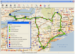
PART is a fleet routing optimization package from
Paradox Software Consulting, Inc. which considers factors such as
volumes, customer delivery time windows and distance. By using the power
of Map Point combined with the heuristics contained in PART you can produce
turn by turn driving instructions to assure that driver efficiency is maximized.
Real-time updates are available via the internet for construction updates
to prevent possible delays. PART was developed in Visual C++ using Object
Oriented Design methodology and Component Object Model concepts.
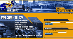
Ship2save transport intelligence solutions
Ship2save has created a software system
that will eliminate the ‘middlemen’ and associated additional costs of present
methods used in the transport industry. The main objective of the Ship2save
transport portal is to provide an effective system for both companies that
ship significant goods via truck transport as well as transport firms themselves.
Ship2save.com has identified that such a system is severely lacking in the
transport industry. Not only would this system reduce costs and optimize
both shippers’ traffic mangers and transports’ truckers/dispatchers time
but it would also provide the customers of the new system extensive reporting
and tracking capabilities.
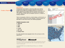
The nation's leading authority
on the behavior of the American consumer
BrandTract
is a new service from Simmons,
the nation's leading authority on the behavior of the American consumer.
Expanding on the Simmons consumer data in MapPoint, BrandTract™ offers online
access to localized consumer usage estimates for thousands of brands and
services measured in the Simmons National Consumer Survey. BrandTract offers
data for any U.S. geography you choose in an easy to use application that
provides PDF reports along with data files formatted for use with Microsoft
MapPoint. Import BrandTract data directly into MapPoint to visualize consumer
usage for everything from brands of peanut butter to brokerage firms used.
Solutions for companies of all sizes
and industries
SpatialPoint’s Store Locator is a popular product or service for any
company with multiple business locations. It enables you to direct customers
searching for a specific product or service to your nearest store, branch
or outlet. Store Locator uses MapPoint Web Service to retrieve high quality
maps and accurate driving directions. Optional enhanced capabilities include
a trip planner, location editor, and location analyzer. Store Locator is
offered as a product or as a hosted Web service.
Where-Tech is a manufacturer of both
vehicle hardware and base software for GPS tracking of fleet activities.
Our solutions integrate detailed GPS position and vehicle status monitor
with MapPoint and MS Access to provide detailed reports of operations in
two formats. The EC500 system is 'passive' Data Logging System and automatically
downloads data each time a vehicle returns to its base location. The M3000
system is internet enabled and give live reports of position while still
recording details for later download over the free short range data radio
thereby keeping cellular costs down.
European Partners
bVisual provides visual software solutions
pinXplorer,
from bVisual
ltd., enhances Microsoft MapPoint to
provide easy-to-use drag’n’drop push pins. pinXplorer was originally developed
for plotting the location of different types of deer over a number of days,
but any two dimensional data sets can be applied, with different colored
and shaped symbols identifying each set easily. pinXplorer provides simple
toggling of name and information balloons of multiple push pins, and allows
push pin notes to be searched and highlighted. The push pins can be imported
from Excel spreadsheets using Lat\Lon, address or OS GB references or exported
back again. pinXplorer turns MapPoint into an effective and useful 2-dimensional
data plotting and analysis tool.
Complete solutions
for vehicle management
 Compucon
S.A. develops and provides integrated software applications and high
technology electronics solutions. Our activities and product lines address
challenges of automated procedures in the industrial environment and the
opportunities of the networking era, by providing integrated solutions in
selected industrial fields. In this dynamic environment, Compucon is committed
to the same values that lead to success: investment in cutting-edge technologies,
investment in people, in innovation, in research and development, in customer
service and support
Compucon
S.A. develops and provides integrated software applications and high
technology electronics solutions. Our activities and product lines address
challenges of automated procedures in the industrial environment and the
opportunities of the networking era, by providing integrated solutions in
selected industrial fields. In this dynamic environment, Compucon is committed
to the same values that lead to success: investment in cutting-edge technologies,
investment in people, in innovation, in research and development, in customer
service and support
Professional services for
organizations requiring expertise across the enterprise
Esporta Health and Fitness, the premium family fitness and racquets
operator identified that improved IT would help its 66 clubs generate and
retain more individual and corporate members. Solutions provider DPR Consulting developed a Business Intelligence
solution based on Microsoft data mining technology. It is enabling Esporta
to take a single view of its customer base and make better decisions regarding
its marketing spend. The health and fitness operator is now equipped with
better knowledge of its customers’ behaviour enabling more informed decision-making.
Mobile solutions for information
channels such as web, wap, sms, mms, pda and voice
mecomo
AG specializes in developing and hosting mobile solutions for all
information channels such as web, wap, sms, mms, pda and voice (focus on
location-based services) based on Microsoft ASP.NET, Visual Basic® .NET,
C#, MapPoint WebService and MapPoint 2004, as well as content (POI) aggregation
and distribution. Customer extract: Vodafone, T-Mobile, Hutchison 3G, O2,
Mobilkom Austria, Connect Austria, BMW, Daimler Chrysler, Sparkasse.de,
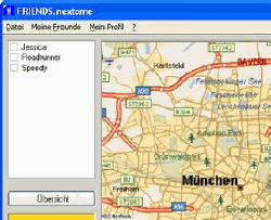
Jamba and Microsoft. With FRIENDS.nextome, users can keep track of their
mobile buddies via the cell information provided by the mobile cell operators.
Buddies that are being tracked have to approve tracking. MapPoint WebService
is used to display the location of buddies on a map, provide address information
and calculate routes from users to buddies.
Custom Marketing
Analysis software solution with Microsoft MapPoint and SQL Server Technology
GeoAnalyzer is
an Business Intelligence and GeoMarketing Solution from New
Network Technology srl which is integrated with MapPoint 2002 and SQL
Server or MSDE, MapPoint, and external charts and OLAP cubes. With this tool
marketing managers can do several analysis and marketing plans by analyzing
company sales, costs, budget and others analysis including planning for
a new product and services launch, with MapPoint territory visualization
and charts.
AutoRoute, MapPoint and
MapPoint Web Services
SpedSoft Market Viewer uses MapPoint to extract addresses to target
for special campaigns. As part of the campaign follow-up, the addresses are
imported as pushpins to a MapPoint map that is divided into different
territories used by the salespeople. When a salesperson double-clicks on
a pushpin, the map shows a balloon with some data. When the conversation
is finished and the form is closed, MapPoint is updated and the symbol on
the pushpin tells the status of the customer. It could be that a meeting
is planned, that the customer has bought the product, or that the salesperson
got a negative response.
|
|
|
|
For more Detailed Product Information, go to
our MapPoint Extension page... HERE.
|
|
|
|
|
|
|
|
|
• Microsoft Maps A New Niche.
More
• Microsoft Releases MapPoint 2002. More
• Microsoft MapPoint 2002 Review.
More
• Microsoft’s MapPoint
Alliance Program. More
|
|
|
|
|
More information
about MapPoint Web Services from Microsoft. More
• SPECIAL REPORT: Microsoft
& AT&T Wireless join forces in providing Location-based Services.
More
• The Gears Have Been Greased.
Mobile Location-Based Services are ready to roll! - Part 1. More
• The Gears Have Been Greased.
Mobile Location-Based Services are ready to roll! - Part 2. More
• XML Web Services, GIS, and
Location Technologies - Part 1 More
• XML Web Services, GIS, and
Location Technologies - Part 2 More
|
|
|
|
Other Microsoft Mapping News
|
|
|
|
• Microsoft's Acquisition of
Vicinity - IDC's Perspective & Outlook. More
• Microsoft SQL Server: Future
Plans for Supporting Spatial Data. More
• Microsoft Redirecting MapBlast
to MSN. More
• The Oscars of Web Mapping.
More
|
|
|
|
|
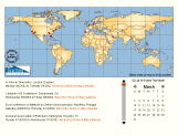
Complete Conference Directory
|
|
Click Map above to see conferences for this
week and the entire calendar of Events
|
|
|
|


 Applied Geographic Solutions, Inc.


 Forensic Logic, Inc.
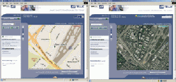
 GlobeXplorer, LLC
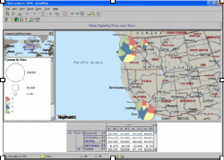
 Mapping Solutions
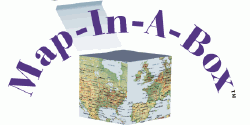
 Mapping Analytics
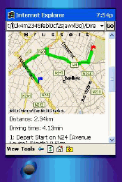
 Panorama Software Ltd.


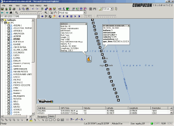
 Compucon SA
 DPR Consulting ltd.