|
|
Welcome
to another issue of
the MP2Kmag Update. The biggest news since the last newsletter is the
recent release of MapPoint 2011 North America! A few years back, the
MapPoint team promised to start doing more frequent releases of
MapPoint to address the #1 request of customers - updated
street data, and true to their word, this is the third release in less
than three years. While not a substantial a release in terms of
changes (for which MapPoint has had mixed reviews anyway such as the
Pushpin Symbols changes in MP09 :-) or new features, MapPoint 2011 does
contain more than 88,000 miles of new roads compared to MapPoint 2010. Updates are in the US, Canada, Mexico and Puerto Rico.
Eric Frost, EditorThe MapPoint Team says they are focused on releasing MapPoint 2011 Europe in the very near future, but we don't have a release date as of press time. Stay tuned for a future newsletter, and to keep up-to-date with breaking news visit MapForums.com and follow us on Twitter. MP2K Magazine is your source for independent news and information about MapPoint and other Microsoft mapping technologies and we also host the popular web forum for MapPoint users and developers (www.mapforums.com). This Issue's Contents at a Glance - What's New in MapPoint 2011 - MapPoint 2010 / MapPoint 2011 Road Comparison - Find Coupons Feature Gone in MapPoint 2011 - MapPoint 2011 Geocoding Improvement - Get Published in MP2K Magazine - Add City Coverage to MapPoint using the GeoNames Database Happy Mapping and please forward this newsletter to anyone who would be interested! |
|||||
|
advertisement
|
|||||
FeaturesWhat's New in MapPoint 2011Frankly, except for the roads update, not a lot. Depending on your perspective, that may be a good thing or a bad thing considering the fiasco with the Pushpin Symbol changes in MapPoint 2009 (since fixed in MapPoint 2010), the product does not have a perfect record regarding major changes in the product. In that sense, MapPoint 2011 plays it safe, and simply delivered updated street data with MapPoint 2011, which is, according to Microsoft, the #1 customer request. So, MapPoint 2011 is basically built on the solid foundation of MapPoint 2010 plus 88,000 miles of new roads. From my own testing, this yields a 2-3% better address match rate and of course you can now route to/from these additional road segments. Larry Peterson on the MapPoint team at Microsoft writes -- "This year we focused on updating our mapping data which is the #1 requested feature. With the 2011 version, you get 1.9 million points of interest (not only updated from 2010 but it was only 1.7million so many more have been added). There are also 88,000 additional miles of navigable roads in 2011 over 2010. That is pretty huge – equivalent to over 15 coast to coast round trips driving San Francisco between New York City." "Product development takes time and release cycles change for a variety of reasons. We’re ultimately committed to delivering top quality to our customers and this is what drives all efforts behind the product." MapPoint 2010 / MapPoint 2011 Road Comparison Since the biggest change between MapPoint 2010 and MapPoint 2011 is the updated road data, I zoomed in to random places around the U.S. where I expected to see growth and additional roads and sure enough -- every place I tried had new roads. This helps with geocoding and routing of course -- if you don't have the road in MapPoint, you couldn't deliver or travel to it in a route! Also, all the (unedited) screenshots are attached as a single zip file. If you download and open in something like the default Windows Photo Viewer, that's probably the best way to flip between the images to see the new roads. Even better, download the trial version of MapPoint 2011 and install side by side with MapPoint 2010 (select Keep Existing Version during the install), open up an instance of both and zoom to your favorite city, and then flip between them. Feel free to add your own screenshots and images as attachments to this thread in the forum! Find Coupons Feature Gone in MapPoint 2011 I never really used it so I don't miss it, but I noticed the Find Coupons button is missing from the MapPoint Toolbar. I don't know where they got the coupon information or if there were any good deals, but I do think it would be interesting to see the daily deals from some service like Groupon or Living Social! Discuss this topic in the forum. MapPoint 2011 Geocoding Improvement With the addition 88,000 miles of new roads [I believe that's the fourth time this has been mentioned in the newsletter :-], you would expect a higher address match rate in MapPoint 2011. I tested one list and found a 2-3% higher match rate. How are you fairing with the new version? Discuss this topic in the forum.  Get Published in MP2K Magazine Get Published in MP2K MagazineIf you have a MapPoint presentation, neat programming technique, or would simply like to share the ways in which you are using MapPoint technology or any other ideas, contact us to discuss how we can turn your knowledge into an article and share your experience with the rest of the MapPoint community of users and developers. Thanks to Marvin Hlavac for allowing us to use the picture on the right of his Maltese puppy eating from the MapPoint mug.
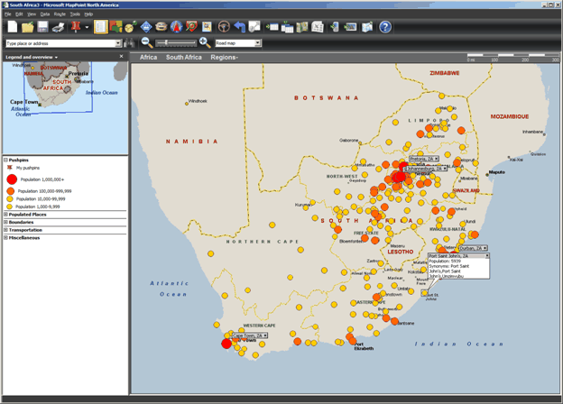
Articles Add City Coverage to MapPoint using the GeoNames Database Add City Coverage to MapPoint using the GeoNames DatabaseRichard Marsden wrote this article on how to add cities for countries not covered by the North American or European versions of MapPoint using the free Geonames database. All programming is done using the powerful Python scripting language. "Users of Microsoft MapPoint often request the ability to import their own data – especially for regions not covered by the North American and European editions. It is not possible to modify MapPoint’s road database or dataset structure, but it is possible to add annotation in the form of pushpins and shapes. Here I demonstrate how to write a Python script to add pushpins for cities in countries with limited MapPoint coverage. A frequent problem is that of finding a suitable source of data. I shall use the open source global GeoNames database of places." "The GeoNames database is available at GeoNames. The database contains over eight million place names, covers all of the world’s countries, and is distributed under the Creative Commons Attribution 3.0 License. The complete database or small extracts can be downloaded as text files, and it can also be accessed using a series of web services. Premium services are available for those who wish to provide financial support, or require professional-grade availability and a service level agreement." |
|||||
|
advertisement
|
|||||
| Look forward to upcoming issues in which we focus on
recent MapPoint and Bing Maps news and share forum highlights. Previous issues of the MP2Kmag Update are available in
the newsletter archive. |
| Copyright 1999-2011 MP2K Magazine |
Please forward this newsletter to anyone who would be interested!


