 |

|
|

|
What's New in Streets and Trips 2006Marvin Hlavac shares a summary of the useful new features and highlights of the consumer product Streets and Trips 2006 including GPS navigation features, Virtual Earth integration and the new Night View.
We here at www.gpspassion.com are excited about the changes Microsoft has been doing to Streets & Trips over the last two versions. Recently at GpsPasSion Forums we looked at the new features of S&T 2006 in the What's New Streets & Trips 2006 / AutoRoute 2006 discussion thread, but it has become quite long (~ 30 pages) and unlikely many people will have enough patience to read it all. Here is a brief summary: Undoubtedly this 2006 version is another important step (just like the 2005 version was) in making S&T usable for in-car navigation.  Voice direction prompts feature has been added, making the product easier to use for in-car GPS navigation. My wish for the next version of S&T would be pre-recorded real human voice (as used by most leading navigation products manufacturers). Here is a sample of how S&T 06 sounds now: MP3 format or WMA format and compare it to iGuidance navigation software for PC and PPC by iNav Corporation: MP3 format or WMA format. 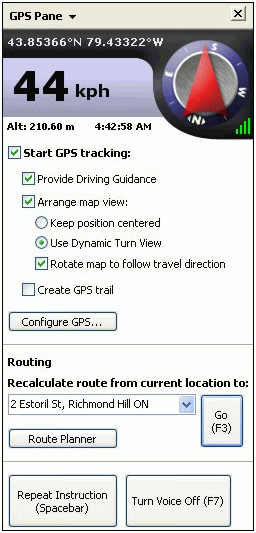 GPS Task pane, which was first introduced last year in Streets & Trips 2005, now has added functionality. Dynamic Turn View is automatic zoom function. When enabled we will see the whole length of the current section of the route starting from our GPS position all the way to the next turn. As we are approaching the next turn S&T zooms in to show us more detail. This is a very useful feature as I personally find that without auto zoom I need to manually change zoom level almost all the time. This function works quite well in S&T 06, but it does have one silly annoyance: the GPS position icon does not stay still! Most of the time the icon is indeed where it should be, close to the bottom in the middle. But when we finish traveling along one segment of the route and we enter the next segment, at that moment the icon starts moving towards the top of the screen. This seems to correct itself after a few seconds when the icon reaches the top and jumps back. This issue of �traveling icon� can be also observed when we deviate from our pre-calculated route. Then you can see the icon literally all over the screen, depending on which way you are moving. This is not acceptable, the icon should not move at all, not even a millimetre. It should be placed in one place on the screen so users� eyes can easily locate it just by a quick glance. 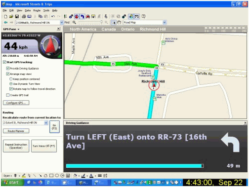 Driving Guidance pane displays next driving instruction, for example Turn Left onto Whatever Avenue. Then there is the arrow icon representing the type of turn to anticipate and the distance in kilometres or miles to that turn. This is indeed needed information, but in my humble opinion the whole Driving Guidance panel is taking up too much space. Perhaps there is really no need for any special panel to display this info, but rather this could be implemented the way other GPS navigation products do it: overlay the arrow and the distance info right on the map. And instead of displaying a long sentence �Turn Left onto Whatever Avenue�, just display the street name only on the very top of the map. S&T 06 is of course better than 05, but it still has a lot of room for improvement. 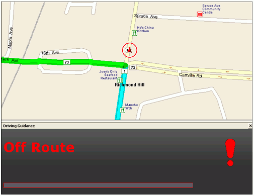 When we deviate from our route S&T 06 will notice it and within seconds we will be notified about it in the new Driving Guidance panel. Then all that needs to be done is hitting F3 function key on your keyboard or easily tapping the large "Go" button in GPS panel if you are using a touch screen. This is improvement from previous versions and let us hope the good guys developing the software will not stop here. We need them to keep on going ;-) Automatic recalculation would be nice. The less driver interaction with the software is required the safer and more fun S&T will be.  Night view introduced in this version may be appealing to many users, but I feel I would be able to orient myself on the map better if colors other than green were used for various road types. But people find this new night view impressive. Feel free to click the small image above to view it (very) big ;-) 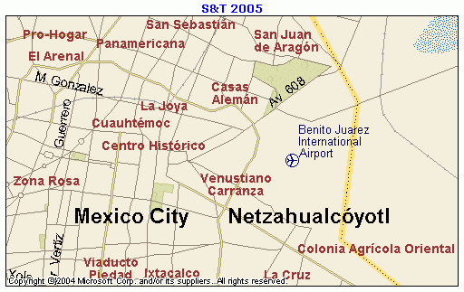
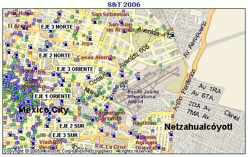 Maps as usually are approximately one year newer, but still lag about 2 to 3 years behind printed maps. The process of collecting data for navigable maps and integrating the data into software products like S&T is long. In this version for the first time we see street level coverage of Mexico City. 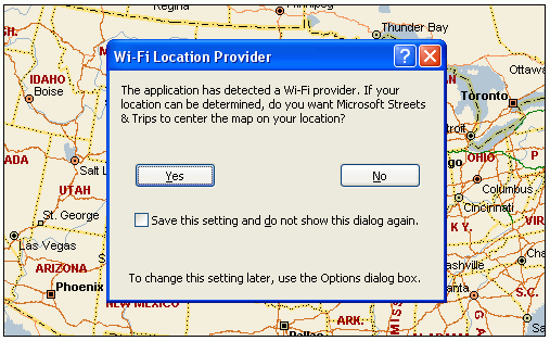 Location Finder uses a database of known Wi-Fi access points to compute your location. If you are in a rural area, or any other area with few known Wi-Fi access points, Location Finder will not be able to determine your position. This new and very interesting feature doesn't seem to work in my area, but I suspect users south of the US / Canada border may have much better luck with it. 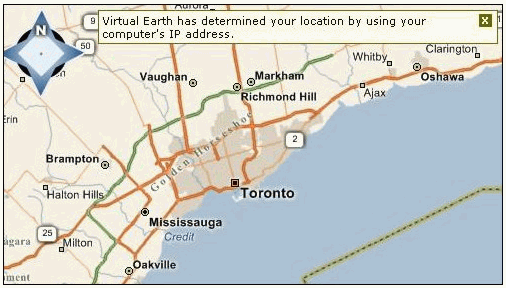 If you are not within the area of known Wi-Fi hotspots the Locate Me service may attempt to determine your approximate location using your IP address. 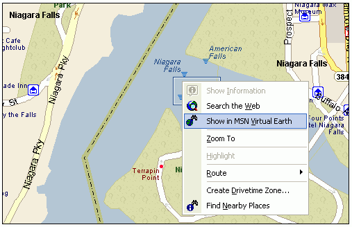 Click on a POI (or anywhere on the road) and go directly to MSN Virtual Earth to see a nice aerial view of the location. Click here to see the result I got when I clicked on the highlighted menu item shown on the above picture. Over all this is a very nice upgrade especially if you intend to use MS Streets & Trips for GPS navigation. Now that S&T 06 already has features needed for in-car navigation I think the team working on the product may want to improve how users experience those features. The graphical user interface of S&T is excellent for trip planning and likely no much change is needed in that area. But when a trip has been planned and users are ready to drive, it would be nice to be able to switch into an optional "navigation interface" specifically designed with the driver in mind. The best example of such "navigation interface" I can think of is iGuidance software. It maximizes visible map area, yet it still manages to display all the relevant information in an unobtrusive manner. Now that users have had two months to familiarize themselves with this new 2006 version we have put together our wish list for next years' MS Streets & Trips 2007. You may view it by clicking here. Let's hope the MS MapPoint Team will keep on adding new features as they have done so well for the past two years. Thanks!
 Author: Marvin Hlavac Author: Marvin HlavacEmail: hlavac [at] rogers [dot] com Marvin runs Laptop GPS World, a website focused on GPS navigation on laptop computers.
|
|
||||||||||||||||||||||||||||||||||||||||||||||||||||||||||||||||||
|
|
||||||||||||||||||||||||||||||||||||||||||||||||||||||||||||||||||||


