 |

|
|

|
Routene Excel and MapPoint UpdateJohn Sewell introduces and explains the features in the latest version of Routene, an Excel spreadsheet for of physical supply chain and logistics applications. A full version of Routene is now available for purchase.
Because MapPoint can be accessed programmatically either from VBA or any other programming language it is possible to use MapPoint to solve a wide range of physical supply chain questions. As part of our business - supply chain consultancy - we have done a number of distribution network strategies; with typical components being how many distribution centres to have, where to locate them and the transport implications of running them. We found that the off-the-shelf tools to solve this are both expensive and completely �black box� - providing an answer but little explanation as to how the answer has been derived. So we started to use MapPoint driven by Excel and created Routene as an Excel add-in. Incidentally, we started in .NET but found response was too slow and the framework cumbersome. Based on David Hager�s article Excel User-Defined Functions and MapPoint, we started using VBA which was both faster and much more flexible. Excel is the ideal place to put results so you can do supplementary analysis with results; this is why we view Routene as a toolkit rather than a �solution�. At the bottom of this article is a link to our web site where you can download the latest version of Routene (v2.5) which supersedes the version mentioned in the original article in 2006. If you have used the previous version you will find a lot of improvements:
Unfortunately we are only providing the full version now for a pretty nominal charge (there is a mostly working trial version free); however if you did contribute I would be happy to send you a free copy, I would particularly like to thank Raphael Yue (China) and Jeff Jaegar (USA) for their comments and challenges that triggered a number of these improvements. So what does Routene do? Below is a list of some of its capabilities.
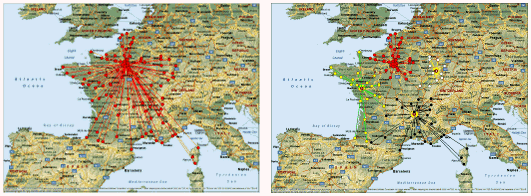
The best thing to do is to get a copy and play with it, there is a reasonably full manual, as much email help as you want (we are still looking for improvements) and a setup file for installation. The toolkit mainly works on MapPoint�s mapping and route planning capabilities (ie not much use of territories) an example of output is this analysis of options for 1 to 4 distribution centres to service France
 Or this diagram showing the one hour driving distance from some chosen sites in England
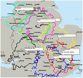
...both of these diagrams are generated by Routene, making use of MapPoint methods.
If you would like to download the trial or buy the full copy - follow this link:
Note that Routene works equally well with North American and European version of MapPoint. I you have any comments or builds after using the tool we would really appreciate feedback.
Author: John Sewell Email: John.Sewell(AT)tamarack-uk.com URL: http://www.tamarack-uk.com John is a supply chain specialist working for Tamarack Partners, a supply chain consultancy boutique based in the UK. This tool has been developed for supporting logistics network modelling and strategizing typically for retailers or consumer goods manufacturers. For more more information see the Our Work and Who We Are sections of our web site.
|
|
||||||||||||||||||||||||||||||||||||||||||||||||||||||||||||||||||
|
|
||||||||||||||||||||||||||||||||||||||||||||||||||||||||||||||||||||


