|

|
|

|
An Overview of the New Features in Microsoft MapPoint 2010Richard Marsden highlights the new features in MapPoint 2010 including the "Map Settings" or cartographic layer pane, new programmatic capabilities for GPS control, GPS import/export and several other major enhancements including MapPoint 2009 "Fixes".
MapPoint 2010 is also the first release since a recent change in emphasis of the development team from the consumer Streets & Trips to the more business-oriented MapPoint. With the emphasis on Streets & Trips, recent versions have added new features like improved GPS navigation but they have lacked a public API (Application Programming Interface). MapPoint 2010 includes a number of API changes which expose much of this functionality, as well as new features targeted at the desktop user. This article is an overview of the new features that have been added to MapPoint 2010.
Ability to Control Map FeaturesSo what has changed? Probably the most significant change is the ability to switch features (and their labels) on or off. I often see requests on the discussion forums and newsgroups requesting labels to be switched off. Well, you can go further, and switch roads, cities, borders, etc off as well. Each feature actually has three settings: on, off, and default. ‘Default’ appears to be an intermediate value. Switching a feature (eg. rivers) from ‘Default’ to ‘on’ actually adds slightly more detail. This new functionality is found on the new “Map Settings” panel. This can be displayed by selecting View->Panes->Map Settings on the main menu. This panel also allows you to set the font size and map style (both are features found in previous versions of MapPoint). Here is an example screenshot where the roads, country names, state names, and smaller cities are hidden:
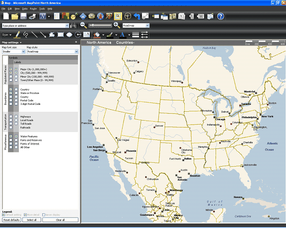
As you can see, it is now very easy to produce maps suitable for presentations which are simple and uncluttered. The full set of symbols and labels that can be set, are:
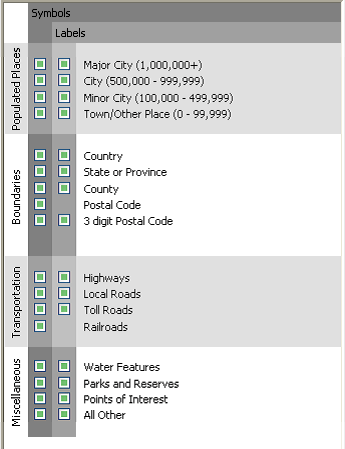
These features are accessible in the API from the Map object’s MapFeatures collection. This is a collection of MapFeature objects. Each MapFeature object has a number of properties, including a Name and a DetailLevel. The DetailLevel is an enumeration that specifies whether the feature should be displayed or not. Here is a C# example taken from the documentation, which hides all the features:
The Map object also has two new methods (BasicRenderingOnly and DefaultRendering) which control the type of map rendering. Choose ‘Basic’ for faster performance, or ‘Default’ for better looking maps.
GPS NavigationAn API has now been exposed for the GPS functionality in MapPoint in the form of the GPSNavigation object. This is accessed from a new Map object property with the appropriate name of ‘GPSNavigation’. This object has one method, Reroute(), which recalculates the route from the current GPS-derived location. Also provided are three boolean properties: FullScreenNavigation, Navigation, and Tracking. These are simply mode properties that allow an add-in or application to set or query the GPS navigation/tracking mode. These are definitely a step in the right direction, but I think many developers who have been looking for better GPS support in the API were also hoping for the ability to query the current GPS location, and perhaps receive GPS-based events (eg. “new location”).
GPX Import/ExportA new facility is the ability to import or export GPX files. GPX is a standard used by handheld GPS devices to store things like GPS tacks and place markers. I’ll have to admit that this is something I have considered adding to one of my own add-in products. It was marginal whether it would be worth it for me (there’s already a free addin available), but Microsoft including it as a standard feature makes the decision moot. Overall, it should make it easier for users to share their data between their mobile / GPS devices and MapPoint (plus I assume Streets & Trips). This is something that has always been lacking, and the need is particularly acute with the demise of Pocket Streets. GPX is supported by Bing Maps (nee Virtual Earth) and the export function is clearly seen as a way of passing information from MapPoint to Bing Maps. The GPX export function includes support for metadata (author, keywords, extents, etc), waypoints, routes, trails, plus ‘additional information’ (search results and pushpin information). GPX support is exposed in the API through the Application object’s ImportGPX() and ExportGPX() methods.
Routing OptionsA number of changes have been made to the routing options and API. It is now possible to reverse the order of the route’s waypoints. This is implemented in the user interface with a button on the Route Planner. The API exposes this functionality through the Route object’s Reverse() method. Construction updates can now be automated using the new Route.UpdateConstruction() method. Another new Route object method is ZoomTo() which can be used to zoom to the current route. Personally I have not found a need for this in the past, probably because it occurs automatically when a route is calculated. Route information can also be sent directly to a GPS navigation device. Again, this is something that has been much requested since the demise of Pocket Streets. Data can be transferred wirelessly using MSN Direct (MSN Direct enabled devices only), or using a USB connection to a Garmin device (Garmin Communicator Plugin required). Location information can also be passed to a mobile phone in the form of a text message. This function uses email and requires Outlook 2003 or 2007. The information that can be passed includes pushpin information, nearby places, and search results. This function is supported in the API by the Map.SendToMobile() option.
Other API AdditionsA number of other features have been added and/or exposed in the API. The Export-to-Excel function is now available in the API through the SelectedArea.ExportToExcel() method. I would expect this new method will be useful for developers writing bespoke desktop applications. MapPoint 2009 introduced the ability to show the current map view in Virtual Earth. This is now available in the API with the Map.ShowInOnlineMap() method. Interestingly, the method refers to neither Virtual Earth nor Bing Maps (the user interface refers to Bing Maps).
Non API ChangesMapPoint 2010 introduces a number of other useful additions. One of the most useful is the ability to drag a pre-computed route from one road to another. The function actually works by inserting a waypoint on the drag-to point. So if you drag from road A to road B, the new waypoint appears on road B, creating a diversion. This does not really add a new function, but it represents a very user friendly way of performing an existing function. I think this will go a long way to answering many of the “how do I modify the computed route?” type questions that are regularly seen on the forums and in the newsgroups. A couple of new features make pushpins easier to manage. Previously, only individual pushpins or complete pushpin sets could be deleted. Groups of pushpins can now be deleted by selecting an area. After selecting an area, right click and the popup menu will give options to delete all pushpins within the selected area OR all pushpins outside the selected area. Previously this was only possible with custom programming. It is now also possible to hide individual pushpin sets. This feature can help improve map clarity. This feature is also available in the API using the Dataset.PushpinsVisible Boolean property With all the different map view settings that now exist, it could take a few minutes for a user to set MapPoint to their personal preferences. This has been solved with a new option on the Map tab in the Tools->Options dialog box. This lets you set the default startup map settings to be either the current settings, or the settings when MapPoint is closed. Alternatively, you can reset the map settings back to their factory defaults.
MapPoint 2009 "Fixes"A number of changes were made to MapPoint 2009 with its new “large button” look. There were good reasons for most of these changes, but many resulted in some quite vocal complaints. Two of these problems have been fixed: First, the forward/backward map view buttons were removed. Due to a general lack of toolbar space with the large buttons, the buttons continue to be absent. However, this much-requested functionality has been re-introduced on the menus. Menu items are not quite as convenient, but at least the functionality is back – users no longer need work-around add-ins like my “Back and Forward Utility”. Both menu items also have hotkeys for the ‘power user’. Secondly, the pushpins were replaced by larger pushpins. This was a good idea, but the number of pushpins and color selection were drastically reduced. Everyone should be happy to hear that MapPoint 2010 now has the full set of MapPoint 2006 pushpins. The pushpins continue to be the larger variety, and about a dozen or so new pushpins have been added. Representations of virtually all of the old ‘2006’ pushpins are present (the Euro sign is the only one I have noticed to be missing). The index numbers for most of the colored symbols remain the same, although the flags have been moved to be adjacent to the other colored symbols. This displaces the index numbers for the letters, numbers, etc.
ConclusionsCompared to recent versions of MapPoint, MapPoint 2010 represents a good, positive step forward. There are a number of new features which enhance its usability and answer a number of frequent user requests. Combined with the new annual update cycle and the recent updates to the add-in offerings, this is a very positive time for the MapPoint user community.
 Author: Richard Marsden Author: Richard MarsdenEmail: enquiries(AT)winwaed.com URL: http://www.winwaed.com Richard Marsden is the proprietor of Winwaed Software Technology, LLC which provides software consulting and development services, specializing in both MapPoint and online mapping applications. He operates the Mapping-Tools.com Website for MapPoint Tools and Utilities, and recently launched the GeoWeb Guru a community website for developers of the geospatial web. In 2008, Richard was awarded Virtual Earth MVP status by Microsoft. Prior to Winwaed, Richard worked as a software developer working on seismic processing algorithms for the oil exploration industry. He holds geology and geophysics degrees from the University of Cambridge (Churchill College), and the University of Durham; and an interdisciplinary MBA from the University of Dallas.
|
|
||||||||||||||||||||||||||||||||||||||||||||||||||||||||||||||||||
|
|
||||||||||||||||||||||||||||||||||||||||||||||||||||||||||||||||||||