|

|
|

|
PliableGIS: Insight to Location-based InformationOne software company that can add functionality to MapPoint 2002 is IDELIX Software Inc. IDELIX has started to create quite a stir with their innovative PliableGIS technology.
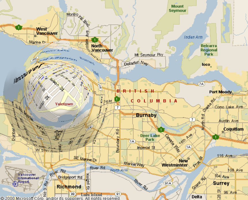
PliableGIS: Giving more insight to location-based information. With the release of MapPoint 2002, Microsoft has raised MapPoint's profile to that of a serious spatial and business information management tool that appeals to an extremely large number of business users. To stand out as the leader in the geography-based information management systems industry, MapPoint must continue to strive to offer end users both unique feature functionality and enhanced usability. One software company that can add functionality to MapPoint 2002 is IDELIX Software Inc., www.idelix.com. Recently referred to by Adena Schutzberg of TenLinks as "the hottest thing on the floor" at the Intergraph Geospatial World Conference, IDELIX has started to create quite a stir with their innovative PliableGIS technology. PliableGIS by IDELIX is a visualization software designed to extend the exploration, presentation, and analysis capabilities of GIS products such as MapPoint 2002. With the recent launch of the IDELIX PliableGIS for ESRI's ArcView 8.1extension validating a strong demand for PliableGIS amongst GIS end-users, IDELIX is ready to turn their attention to validating their product in the eyes of MapPoint 2002 users. As Stuart Bourhill President and COO says, "We recognize the opportunity MapPoint 2002 has presented to both end-users and developers like IDELIX with its focus on increased functionality, a more comprehensive object model, and improved support for broad business application deployment. As a Microsoft business partner , IDELIX is aggressively exploring possibilities for PliableGIS to be integrated within MapPoint-powered applications to empower Microsoft's end users with the unique functionality of PliableGIS. " Powered by Pliable Display Technology (PDT), PliableGIS is a unique technology that allows users to navigate and magnify large images and maps in a way that is more intuitive and efficient than existing zoom, pan and inset viewing technologies. These existing technologies fail to address what's known as the screen real estate problem. Today, as you zoom into an area of interest on a map or image, you quickly lose a view of the surrounding area. This results in a loss of navigational cues and forces the question "Where am I?" It is not possible to see both the detail and the context together.
featured resources
PliableGIS is a powerful new data exploration and presentation tool designed to increase end-user productivity and workflow efficiency. Unlike existing zoom, pan and inset window functionalities, no information is hidden or moved off the display. PliableGIS produces a virtual lens within a map that enables users to see detail without losing a view of the "big picture". Using this unique lens technology, users can now efficiently navigate and analyze directions and regions of interest while maintaining a view of the mapped out area in its entirety.
PliableGIS is the perfect tool for Microsoft to enhance many of the new features made available in MapPoint 2002. Given the unique functionalities associated with PliableGIS, MapPoint users would be able to make more informed business decisions through improved display, exploration and analysis of MapPoint's up-to-date location and demographic data. With the new addition of ActiveX� Control and the increased mapping functionality in MapPoint 2002, PliableGIS would also be able to address the demand for more accurate, efficient viewing and analysis tools across a number of vertical markets. For example, with PliableGIS, users would be able to fully utilize the complete combination of high-quality terrain, political data and roadway maps that are unique to the MapPoint 2002 application. PliableGIS would also provide greater map customization tools, more accurate territory creation, and enhanced display tools. Using the scale dependent rendering abilities of PliableGIS, MapPoint customers would be able to "drill down" into their data sets and include any combination of the 70 measures of demographic data, address finding and multipoint routing functionality, as well as shaded-area mapping to appear at any chosen level of magnification within the lens focal region. Users would be able to view updated and expanded map content and demographic data without loosing a view of the surrounding area, setting these data layers to appear at the desired magnification level within the lens. This is critical to effective decision-making. The ability to activate multiple lenses within PliableGIS would enable the viewing of two regions of interest on a customized map, so regional or territory performance information can be easily compared and analyzed. Information from two areas of interest such as census tracts, postal codes, counties, sales or customer data can be compared and analyzed, improving current territory management abilities - all within the same window. With the new Drivetime Zones analysis tool, built on Microsoft's patented routing technology, PliableGIS would be able to track, in real-time, the end-user's journey and let them see the detail of the exact areas where they are located on the map, bringing in valuable location-based services detail and navigational cues such as surrounding streets, stores, and coffee shops. Custom icons and pushpins could be displayed and edited in real-time, communicating locations of customers, retail locations or other points of interest as the lens moves. Within the lens, distance co-ordinate measuring would also be possible, producing a more accurate and visually enhanced displayed for the end user. PliableGIS is targeted at end-users and developers who will intuitively take advantage of the product's features, and immediately realize a gain in productivity and analysis capabilities. With the ability to operate across all platforms, PDT is in alignment with the Microsoft vision to empower people through great software - any time, any place and on any device. As Stuart Bourhill sums up, "PliableGIS is just the missing tool users need to access and present GIS data and share it with non-GIS savvy, yet highly productive, business users. We look at MapPoint 2002 and the direction it is advancing in as an opportunity for IDELIX to demonstrate to MapPoint users the potential advancements of the product's current features and functionality. I am fully confident in our ability to enhance the end-user experience, and look forward to the feedback many of the MapPoint 2002 users can give us on our technology." For more information about PliableGIS, visit the IDELIX website at: www.idelix.com.
Author: Stacy Gorkoff Email: sgorkoff(AT)idelix.com URL: http://www.idelix.com
|
|
|||||||||||||||||||||||||||||||||||||||||||||||||||||||||||||||||||||||
|
|
|||||||||||||||||||||||||||||||||||||||||||||||||||||||||||||||||||||||||