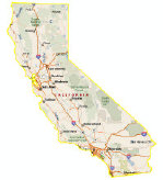
spacer1
spacer2 1_1 1_2
2_1
 Subscribe
 The MP2K Update!


 Magazine
Front Cover
What's New
Articles
News
Sample Data
Gallery
Advertise
About
 Features
MapPoint 2011
Press Releases
MapPoint Forums
Companies
Link to MP2Kmag
Wish List
MapPoint Trial
Authors
 Earlier Content
Past News Items
Past What's New Announcements
 Sponsors
 Order

MapPoint 2011

Programming MapPoint in .NET

MapPoint Book

  Spatial Community
SVG Tutorials
MapPoint

Map Visitors

  DISPLAY INDIVIDUAL STATES  

     
US State Mapping Template
The US State Mapping Template allows you to create maps of single or multiple adjoining states with Microsoft MapPoint.

Buy it now for $75.

Make maps of individual or multiple states. For various purposes, many users of MapPoint would like to cover up neighboring states for their maps in MapPoint. This tool allows you to do that.

To see it in action, download this MapPoint map showing Nevada.

You can see it's not perfect - the labels at the edge of the state are chopped off, unfortunately this is the best you can do with MapPoint.

There's a couple steps in creating an individual state map which requires some experience with MapPoint shape objects.

To re-create the Nevada map, download this file.

Type Nevada, US in the Find box and hit OK when the dialog comes up.

Click in the center of the map, it will select the Nevada shape object.

Next, at the bottom in the Drawing toolbar, change the line to black and the fill to "No Fill". That will show the Nevada Map just as is in the first download.

That's it! Purchase the full U.S. MapPoint map file which will allow you to create maps of any state below.

Order for your whole team! For information on volume discounts or to send a check or money order contact website@mp2kmag.com.

   Forum: Read/Post Msgs

If you need a custom solution displaying maps of individual countries or U.S. counties or something else, let us know, we would be happy to work with you to meet your needs.


Google
 
MP2Kmag Internet


 Recent Discussion
-bingmaps: RT @Chinwag: Breaking Records: The Most Connected Games Ever with @ColinRayJackson @bing @C4Insider #event #olympics /by @beyond http:// ...
-bingmaps: In London next week? Last chance to register for our free breakfast networking event https://t.co/yEJ493OR #bingmaps
-bingmaps: Our good friends @ShoothillLtd have been shortlisted in the Guardian Innovation Awards for FloodAlerts app. Take a look http://t.co/73s5oAhr
-MapPoint 2004 help?
-Text Box Font is HUGE!
-bingmaps: RT @ChrisPendleton: In case you missed my #location2012 talk, @OrdnanceSurvey has posted a recording: http://t.co/p5dcMTpN
-Upcoming WhereCamp Berlin 2012
-MapPoint for World Maps?
-Beginner stuck-what am I doing wrong?
-Mappoint 2011 Europe -> tooltip and update possibilities
-bingmaps: FREE BING MAPS EVENTS IN GERMANY: München https://t.co/pFJZxDdE Köln https://t.co/zerD99GK #bingmaps
-bingmaps: FREE EVENT: @BingMaps and @Beyond present a vision of the London 2012 Games: The Most Connected Games Ever. https://t.co/yEJ493OR
-Need Several Radius imported into a map
-Automatic generation of Drive Time zones around PushPins
-C# Code To Load Older COM Version
-Successful MapPoint Web Service (MWS) to Bing Maps Conversion
-bingmaps: @Sonray Please direct your question to our technical forum which is monitored by our developers: http://t.co/dEfOwFBC
-bingmaps: New Bird’s Eye Imagery & Streetside Coverage on Bing Maps! http://t.co/iJPu0McQ
-I have an excel spreadsheet that has number of houses on roads, can I link this to mappoint?
-Microsoft MapPoint 2011 Construction Data Update May 4th, 2012
-Mappoint 2011 and the built in database
-Using Excel and mappoint
-Extracting ZipCode With Lat/Long
-DataLink Problem!
-bingmaps: Integrating Bing Maps With WPF:http://t.co/HzdriaMs
 Resources


Want Your Site To Appear Here?

   © 1999-2012 MP2K. Questions and comments to: website@mp2kmag.com
  Microsoft and MapPoint 2002/2004/2006/2009/2010/2011 are either trademarks or registered trademarks of Microsoft.