 |
|
|
|
Mapping-Tools Releases GridImp v2.0
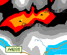 "GridImp is designed to plot gridded data in MapPoint - a type of data that cannot normally be plotted in MapPoint. Gridded data can be indexed in various coordinate systems and text file formats.
"Version 2.0 adds the ability to define custom linear input coordinate systems, and to use UK Ordnance Survey Grid References. Grid References are correctly plotted in both MapPoint 2002 & 2004 - circumventing the grid reference bug in the European Edition of MapPoint 2002."
Read the press release.
 Forum:
Read/Post Msgs
Forum:
Read/Post Msgs
advertisement

|
Working
with pushpins in
MapPoint? Get the Microsoft MapPoint Pushpin Tool for just $75. The
latest features include the ability to export lat/lon coordinates of
pushpins to Excel and advanced find Pushpin functionality. Read more
and purchase the tool here
or go
directly to paypal.
Affordable
volume
licensing
now available for
organizations wishing to distribute the Pushpin Tool to 5, 10, 20, or
50
or more users.
|
|
|
|
|
|
|
Recent Discussion
|
|
|
|
|
|
|
|
|
|
Resources
|
|
|
|
|
|
|


