 |
|
|
|
Virtual Earth December Updates
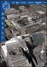 Virtual Earth has added over 36 TB of data to Live Search Maps and the Virtual Earth platform including bird's eye imagery, aerial and satellite photos, and 6,000 sq. miles of 3D buildings in dozens of cities around the world. Virtual Earth has added over 36 TB of data to Live Search Maps and the Virtual Earth platform including bird's eye imagery, aerial and satellite photos, and 6,000 sq. miles of 3D buildings in dozens of cities around the world.
From the VE Team blog:
- 44 new hi-res orthos (aka aerials) from 3Di using the UltraCam
- 36 new US areas of Pictometry Bird�s Eye oblique scenes
- 26 new EU areas of BLOM Bird�s Eye scenes
- 5 areas of US orthos from GlobeXplorer
- 17 areas of orthos around the world from GeoEye
- Updated orthos in England/Wales/Scotland from Getmapping.
- Holland orthos from DKLN.
For more information see the following Microsoft blog posts:
 Forum:
Read/Post Msgs
Forum:
Read/Post Msgs
advertisement

|
Working
with pushpins in
MapPoint? Get the Microsoft MapPoint Pushpin Tool for just $75. The
latest features include the ability to export lat/lon coordinates of
pushpins to Excel and advanced find Pushpin functionality. Read more
and purchase the tool here
or go
directly to paypal.
Affordable
volume
licensing
now available for
organizations wishing to distribute the Pushpin Tool to 5, 10, 20, or
50
or more users.
|
|
|
|
|
|
|
Recent Discussion
|
|
|
|
|
|
|
|
|
|
Resources
|
|
|
|
|
|
|


