Welcome to another issue
of the MP2Kmag Update. If you voted or have been following the U.S.
Presidential election, I hope your candidate won. As it appears George
"Dubya" Bush will be occupying the White House for another four years,
this is used as the example in this issue's installment of Programming
With MapPoint and Excel.
MP2K Magazine is your source for independent
news and information about MapPoint
technologies and products and is home to the popular web forum for
MapPoint users and developers. This month we feature an article from
Keith Armonaitis, the President and Co-Founder of Cubistix, who
discusses the challenges and pitfalls surrounding a implementation of
the MapPoint Location Server.
This Issue's Contents at a Glance
- features: The House of Dubya,
Programming Challenge, Upcoming Articles, Winner in Reader Poll
- articles: MapPoint Location Server
Integration, Pocket Streets 2005 FAQ, Interview with Michael Graff
- news: Pocket Streets 2005,
CacheMinder, KeyNote Helps MapPoint Web Service, Free MapPoint
Developer Seminar
- forum: Forum Highlights, Google
Search Tool, Nearly 8,500 posts and Over 1,500 Registered Users
Happy Mapping and please forward this newsletter to anyone who would be
interested!
|
|
advertisement
|

MapLinX
Pro: The Ultimate Database Tool
for Microsoft MapPoint!
|
MapLinX Pro is
a full-fledged add-on query
tool
that is seamlessly integrated with MapPoint
2002/2004.
This scalable solution is designed to meet the needs of any sized
business, whether you are a single proprietary user or part of a
large-scale global enterprise it can help you provide extensive
business intelligence capabilities including the ability to geocode,
query, map and analyze corporate information upon virtual maps with
minimum effort.
|
|
|
Features
Developing with
MapPoint and Excel, Part II - Mapping An Address
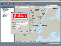
In the last issue we showed how to set
up a VBA macro to instantiate MapPoint. However, we did not do
anything useful! In this mini-tutorial we will demonstrate how to read
an Excel cell's contents and use it as input to geocode a location on a
map. This could be the start of a Excel-based batch geocoder or an
element of an Excel application which may perform routing or batch
distance calculations. The possibilities are endless.
So that we are on the same page, start by downloading this worksheet: House_of_Dubya.zip
You may substitute your own name or address as desired - or needed if
you are using the European maps. Next turn on the Visual Basic menu and
open the Control Toolbox. Now click on Command Button and draw a button
directly onto your Excel spreadsheet. With design mode still on, click
away from your new button and then double-click on the button. This
should open the Microsoft Visual Basic window and as in the last
tutorial you could see the code:
Private
Sub
CommandButton1_Click()
End
Sub
Again, go to Tools | References and include the Microsoft MapPoint 11.0
Object
Library. Compared to the last tutorial, there are several things added
to the code. The Method we are most interested in and want to take a
look at is FindAddressResults.
object.FindAddressResults([Street], [City], [OtherCity], [Region], [PostalCode], [Country])
Here is the complete code, replace the default contents of the Visual
Basic window with the lines below.
Dim
oApp As MapPoint.Application
Private Sub CommandButton1_Click()
Set oApp = CreateObject("MapPoint.Application.NA.11")
oApp.Visible = True
Set objMap = oApp.NewMap
Set objLoc = _
objMap.FindAddressResults( _
Worksheets("Sheet1").Cells(2, 2), _
Worksheets("Sheet1").Cells(2, 3), , _
Worksheets("Sheet1").Cells(2, 4), _
Worksheets("Sheet1").Cells(2, 5))(1)
objMap.AddPushpin objLoc, _
Worksheets("Sheet1").Cells(2, 1)
'objMap.DataSets.ZoomTo
End Sub
Close the Visual Basic window, turn off design mode, and
click on your button. If you run the code exactly as shown above, you
should see a small Pushpin near Washington D.C. Now uncomment the last
line and run the code again. It should zoom into the heart of
Washington D.C. and center on the Pushpin. You have located Dubya's
home for the next four years. See the help file for more examples and
detailed descriptions of the parameters for the statements above.
In the next issue we will show how to add a textbox to the maps. Again,
if something is not working right or you
need additional help, feel free to post your question in the forum
area for this mini-tutorial. Also, let me know if there's any
technique or topic you would like to see in future installments of
Programming MapPoint and Excel.
- Eric
Frost
BONUS TIP:
It's a little late to be of use to anyone in the United
States general election earlier this week, but this map uses simply a
list of states and url's in a text file + MapPoint 2004 to create a
hyperlink map
linking to information on how to determine
your polling place in each state.
Interested
in authoring a
"HOW TO" article or tutorial about
working with MapPoint? Inquire about our submission
guidelines.
MapPoint
Programming Challenge - Submit Your
Solution and Win!
Time to show off your MapPoint development skills!
Take a look in the forum at this MapPoint Route
Optimization anomaly for your chance to receive recognition and win
prizes.
Route Optimization in MapPoint will sometimes hang. Often it is due to
a bad stop which can be detected and adjusted, but it can also occur
even when all the stops check out as OK. Share your solution on the
best way to handle these situations.
 MP2K Magazine
Upcoming Articles MP2K Magazine
Upcoming Articles
Next month we will be publishing Part II of Richard Marsden's popular
article on creating maps of earthquake hazard data and recent
earthquakes. Also look for articles on Creating a MapPoint
Add-in, using MapPoint in PowerBuilder, and programming MapPoint
2004 with Python.
If you have a MapPoint presentation, neat programming technique, or
would simply like to share the ways in which you are using MapPoint
technology, contact us to discuss how we can turn your knowledge into
an article and share your experience with the rest of the MapPoint
community of users and developers.
Reader Poll and
Drawing - How Do You Use
MapPoint?
 Congratulations to Brian McGrath who wins a
Large MapPoint Mug for
having responded to our poll - How Do You Use MapPoint? Brian uses
MapPoint as the GIS brains of an Emergency Services dispatch training
simulator that operates as an interface to a computer-aided dispatch
system. More details can be found on his web site - http://www.brimacsystems.com.
Would you like a mug? For your chance to win, please share how you use
MapPoint.
- Fleet / Vehicle Tracking and Management
- Site Selection or Demographic Analysis
- Professional Developer / Varied
- Real Estate
- Health Care Industry
- Delivery Routing or Analysis
- Marketing
Click
here to respond to the poll and enter this month's drawing.
|
|
advertisement
|
 Microsoft
AutoRoute 2004 Clearance - Need European Maps? Microsoft
AutoRoute 2004 Clearance - Need European Maps?
In North America and traveling to Europe
or have a
need for European maps? Our
remaining inventory of AutoRoute 2004 is being offered at a clearance
price of just $37.99. Free shipping to North America only.
You must click
here to take advantage of the special offer. There will never
be a more ideal time to get European maps.
We also
have one copy of MapPoint 2004 European maps available for $299. The
European maps are not available from retailers in North
America anywhere else. Click
here to order, when it's gone it's gone!
|
|
|
Articles
 Microsoft Location Server Integration: A Project
Manager's Perspective Microsoft Location Server Integration: A Project
Manager's Perspective
MLS, being a Web
service, is pretty straightforward from a programmer's perspective. But
for a project manager, there can be other tricky issues. Here's a peek
at a real-world project.
"As developers, we often want to jump right in and start coding; it is
our passion, and often our most comfortable way of looking at the
projects we deal with. As a project manager, though, I cringe when I
see developers on my team start with this code-centric approach to
projects (although, in all honesty, I have been guilty of it myself).
With certain technologies, however, there are concerns that must be
addressed well in advance of implementation, or you run the risk of
having issues take over that are outside of our sphere of control..."
 Full
article text
Full
article text  Discuss
this story
Discuss
this story
 Microsoft Pocket Streets 2005 FAQ Microsoft Pocket Streets 2005 FAQ
Pocket Streets 2005
offers map guide functionality for Windows Mobile Devices. This
software makes it possible to create customizable maps, prepare
complete itineraries, and locate places of interest such as
restaurants, ATMs, shopping centers, transportation, tourist
attractions and more.
"Q: What’s new with Pocket Streets 2005?
A: New features include the following:
• Retail availability. Microsoft® Pocket Streets 2005 is available
as a stand-alone product in major retail stores and contains the
Windows Mobile™-based Pocket PC and Smartphone versions. Previous
versions of Pocket Streets were only available by purchasing a
downloadable version from Handango.com or with the purchase of a
Microsoft mapping product, such as MapPoint®, Streets & Trips
or AutoRoute™. The retail version of Pocket Streets 2005 will come with
approximately 300 maps of North America and 275 maps of Western Europe
in the box..."
Full
article text
Discuss
this story
 With Microsoft’s MapPoint Division, Location is
Everything With Microsoft’s MapPoint Division, Location is
Everything
Q&A:
Microsoft recently released Streets & Trips 2005 with GPS Locator,
a new consumer mapping and trip planning package that includes the
company’s first Global Positioning System device. Michael Graff, leader
of the MapPoint Business Unit, shares the company’s vision for the
future of location-based technology.
"AAA estimates that a record-number 34.1 million Americans took to U.S.
highways over the Sept. 3-6 Labor Day holiday weekend, a 2-percent
increase over last year. Auto travel reigned supreme with more than 84
percent of all holiday weekend travelers preferring their cars over all
other modes of transportation. Although recent travel research
indicates that four out of five Americans experience elevated levels of
stress during summer driving vacations, only a quarter of drivers hit
the road prepared, according to ARA Content Research..."
Full
article text
Discuss
this story
Submit an article
for publication and
receive a free Large
MapPoint Mug!
MapPoint News
 Pocket
Street 2005 Available As Stand-Alone Product Pocket
Street 2005 Available As Stand-Alone Product
The
latest version of Pockets Streets is now available as a stand-alone
boxed product. While originally introduced as a free product, it was
later available for purchase as a software download through
Handango. Notably, the map areas available for Pocket Streets continue
to expand internationally.
Pocket
Streets 2005 Now for Smartphones and Pocket PC's
From
Digital-Lifestyles.info
- Pocket Streets 2005 "is an ideal companion for any tourist visiting a
city for the first time. You can locate the nearest ATM or service
garage, in fact Pocket Streets has an extensive in-built list of bank
ATMs and public transportation sites. You can customize maps with
personal points of interest, and a new measurement scale feature is
expected to determine the distance between locations more accurately."
Pocket
Streets 2005 Downloadable Maps
Several
hundred maps for Pocket Streets 2005 are now available. Maps for
Australia, Brazil, and also Athens, Greece are among the maps available
in .mps format. The full list and links to download the maps can be
found on Microsoft's Download Center.
Pocket Streets 2005 Hits the Road
From infoSync World
- Pocket Streets 2005 offers
GPS support for both Pocket PC and Smartphone devices, and will be
compatible with new downloadable maps available only to Pocket Streets
2005 customers for more than 575 cities in North America, Western
Europe, Australia, Brazil and Greece..
 Keynote
Helps MapPoint Web Service Performance Keynote
Helps MapPoint Web Service Performance
Keynote Systems announced
that Microsoft Corp.'s MapPoint Business Unit has chosen Keynote
Performance Scoreboard and Keynote Diagnostic Service to track service
level compliance in the unit's MapPoint Web Service operations center.
Keynote Performance Scoreboard is a customized portal for companies
with multi-location and multi-property environments for the visual
management of service level objectives.
 Free
MapPoint Developer Seminar from MSDN Free
MapPoint Developer Seminar from MSDN
Microsoft will be
offering a free demonstration on how developers can get started with
the MapPoint Web Service as part of the the MSDN Web Application
Development Series that is crossing the nation in Oct/Nov/Dec. In
addition to covering aspects of ASP.NET and VS.NET development, this
half-day seminar will dedicate a full hour on how to unleash power of
location with the MapPoint Web Service.
Winwaed
Releases v1.1 of the GridImp Utility
New Features in v1.1
include improved polygon optimization (this results in much faster
drawing, as well as faster MapPoint operations with the resulting map),
improved extrapolation (extrapolations from a relatively small area to
a much larger area are now much faster), support for Unix/Linux data
files, and an improved XML parser.
MapPoint
Location Server Gets Plug in InformationWeek
From InformationWeek - "Before
year's end, Sprint is expected to introduce a service that uses
Microsoft's MapPoint Web Service and MapPoint Location Server to let
companies track field-service representatives, vehicles, or other
assets as they move around the United States. Businesses can expect to
see a growing number of similar offerings from other location-service
providers..."
New
Microsoft Streets & Trips 2005 With GPS Locator
Microsoft
Corp. announced the availability of Microsoft Streets & Trips 2005
with GPS Locator, a product that combines the company's first GPS
hardware device with the latest version of the best-selling mapping and
travel planning software for the United States and Canada. Streets
& Trips 2005 with GPS Locator provides real-time GPS tracking and a
comprehensive array of maps, driving directions and points of interest
to help travelers know exactly where they are and where they are headed
at all times.
 CacheMinder
v1.0.0 Now Available CacheMinder
v1.0.0 Now Available
CacheMinder is a database
application based on ADO.NET
technology that is capable of performing powerful database operations
with geocache data. It is designed to assist in managing geocaches
while catering to your personal
preferences and criteria. If a valid installation of
MapPoint 2004 is present on your system, mapping features
are automatically enabled allowing viewing and editing of geocaches
directly
on the map within a custom mapping interface.
Submit your press
release or news item!
Microsoft and Technology News
 Tele
Atlas Location Content Powering Top Internet Portals Tele
Atlas Location Content Powering Top Internet Portals
Tele Atlas, a provider of
digital map data and location content, is delivering mapping data to
drive the top Internet portals and other important consumer services.
Among the leading portals and travel sites using Tele Atlas content are
MapQuest, Yahoo!, MapPoint and Switchboard. Top wireless companies,
including Verizon, Cingular, ATTWS and NEXTEL have also launched
applications that utilize Tele Atlas data.
Google
Acquires Keyhole Corp
"With Keyhole, you can fly like a
superhero from your computer at home to a street corner somewhere else
in the world - or find a local hospital, map a road trip or measure the
distance between two points," said Jonathan Rosenberg, vice president,
Product Management. "This acquisition gives Google users a powerful new
search tool, enabling users to view 3D images of any place on earth as
well as tap a rich database of roads, businesses and many other points
of interest."
 World's First, Smallest and Lightest, Global
Locator Phone World's First, Smallest and Lightest, Global
Locator Phone
Wherify Wireless
demonstrated the Wherifone G550 for the first time at the CTIA IT &
Entertainment business show last week. Wherify plans to begin
manufacturing the Wherifone G550 this year for international
distribution, followed by additional location-based products for
valuable assets, cargo, vehicles, and pets.
Identify
Geographical Location of Internet Address Space
IP2Location is a database
product that enables Web sites to identify the geographic location of
their visitors using IP addresses. The database is used to match an
incoming IP (internet protocol) address to the country, region, state,
city, latitude, longitude and Internet service provider (ISP) of the
Internet user.
NAVTEQ
Global LBS Challenge
NAVTEQ, a provider of digital map data for vehicle navigation and
location-based solutions, has joined forces with influential location
technology and media companies to sponsor the Global LBS Challenge: a
contest that challenges developers to build location-enabled
applications for wireless devices. The corporate sponsors include ESRI,
Microsoft Corp., SiRF Technology, Inc. and Telcontar.
|
|
advertisement

|
Working
with pushpins in
MapPoint? Get the MapPoint 2004 Pushpin Tool for just $75. The
latest features include the ability to export lat/lon coordinates of
pushpins to Excel and advanced find Pushpin functionality. Read more
and purchase the tool here or go
directly to paypal.
Affordable volume
licensing
now available for
organizations wishing to distribute the Pushpin Tool to 5, 10, 20, or
50
or more users.
|
|
|
Forum
Highlights
Some notable posts and
solutions from the forum over the past few
months are listed below. Keep up with the latest news and information
about MapPoint by bookmarking the forum and visiting regularly. There
are now nearly 8,500 posts and in the forum and over fifteen hundred
registered users.
In addition to the Search
function built into the forum near the middle-top of the page, forum
members frequently use Google to search the MP2Kmag forum. You can now
find a search box at the bottom of the forum to aid in your searches
and make your hunt for valuable MapPoint knowledge a little easier.
Tuesday, November 2nd
ActiveX
Performance with .NET
TIP:
Creating A HyperLink Map to Find Polling Place
Correlation
Between MapPoint FIND function and MPC???
Secure
access to map
[1
reply]
Having
Problems Getting Location from Pushpin
ASP
& KIOSK integration
[1
reply]
Monday, November 1st
Stop
User from exiting
[1
reply]
Adding
pushpins by lat/long or address using MPC in MSAccess
Sunday, October 31st
Looking
to Hire MapPoint Web Service Developer
Microsoft
Pocket Streets 2005 FAQ
Tele
Atlas Location Content Powering Top Internet Portals
Saturday, October 30th
Reverse
Geocoding with c#
Friday, October 29th
Making
MapPoint talk / Driver-friendly MP?
[1
reply]
Problem
with VB.Net
[9
replies]
MapPoint
Installed Detection
[1
reply]
Import
data from a file into Map Point using VB Code?.....
[1
reply]
ActiveX
Calculate function have a bug?
What
is the diference between MapPoint versions
[1
reply]
Fleet
definition
[3
replies]
Drawing
in MapPoint 2004
[2
replies]
Thursday, October 28th
Placing
PushPins using VBA programing
[3
replies]
Pocket
Streets PSP file
MapPoint
shortcomings
Northern
Ireland Postcode Districts
Long/Lat
from click.
[7
replies]
Wednesday, October 27th
MapPoint-ZOOM
[1
reply]
Person
Tracking
C++
and passing Variant Arrays
[3
replies]
Can
you change the style of a map?
How
can I export POI data?
[3
replies]
Map
for tracking on the sea
[1
reply]
New
feature request
How
can I link an Excel pivot table with MapPoint?
How
can I link MapPoint with Excel?
[1
reply]
MapPoint
& Excel
Tuesday, October 26th
Printing
a Corresponding list of Addresses from Pushpins
How
to get the Locations for the 4 vertices of a Square?
Monday, October 25th
Event
gets called when pushpin is deleted
[1
reply]
Difference
Between MapPoint 2002 and 2004 in lat/lon.
[4
replies]
Sunday, October 24th
Link
Data Wizard fails
Friday, October 22nd
Unable
to add Mapinfo files to MapPoint via Com Add-In
Lat/Long
with Pushpin -- question?
[2
replies]
MapPoint
2004 and Delphi 5
[2
replies]
Thursday, October 21st
Cut
and Paste Problem with Word 2003 and MapPoint 2004
Hide
Canada and Mexico
[3
replies]
MapPoint
ActvieX and .Net Web Application
[1
reply]
VBA
help needed using MapPoint.Application object
MapPoint
question please help!!!
[2
replies]
How
can I refresh the data link from VB
[2
replies]
Mappoint
ActiveX control 9.0
[1
reply]
Mppoint
object library
[1
reply]
Wednesday, October 20th
Creating
a static info balloon from data queried from a terr
Copying
the Legend to paint or MS PowerPoint
[1
reply]
Name
of Cities
Find
streets in a selected area
DriveTimeZone
Delphi
Returning
the Latitude & Longtitude in VBA
Tuesday, October 19th
Show
mappoint map on web page
[4
replies]
Location.
StreetAddress is nothing
Performance:
UDL vs Access Linked table
Mappoint
2004 - ActiveX -- Print dialogue
[1
reply]
Keynote
Helps MapPoint Web Service Performance
FindPushpin
problem
[2
replies]
Monday, October 18th
Bad
Coordinates returned by imagebutton on dell d800
Trapping
Bad Routes in VB6
[4
replies]
Saturday, October 16th
Cacheminder
v1.0.0 Now Available
Zip
Code Update
Friday, October 15th
NAVTEQ
Global LBS Challenge
Thursday, October 14th
Visual
Studio
[1
reply]
Set
Map Title with VBA?
Arrow
size
Programming
multiple pushpins with MapPoint Webservice
Wednesday, October 13th
VC++
OnSelectionChange event
Postal
Code
[1
reply]
Tuesday, October 12th
MapPoint
EULA Question
[1
reply]
Order
a recordset?
[3
replies]
Delphi
iterate pushpin dataset
[1
reply]
Monday, October 11th
Making
Sq. kilometre territory's
[3
replies]
Sunday, October 10th
Print
a map area according to block and lot(nyc)
[1
reply]
Importing
X and Y Coordinates
[2
replies]
Saturday, October 9th
Help
Again?
Friday, October 8th
Problem
linking MApPoint DB2 - UDL
Thursday, October 7th
Please
help a desperate student!!
[1
reply]
How
to save map as *.ptm programmatically in MapPoint?
[3
replies]
Wednesday, October 6th
Automating
Mappoint using VB
[1
reply]
With
Microsoft's MapPoint Division, Location is Everything
[2
replies]
New
Microsoft Streets & Trips 2005 With GPS Locator
How
to make embedded MapPoint File Menu accessible
Driving
distance between two postcodes
[2
replies]
Connection
between Microsoft Access and MapPoint
[1
reply]
Tuesday, October 5th
Lat
/ lon
[1
reply]
Some
interesting geo facts
[1
reply]
Mappoint
2004 won't load after install. Any ideas?
[6
replies]
Find
city name & state name on mouse move event
[2
replies]
Labelizing
the Map
[3
replies]
Question
on Legends
Monday, October 4th
Imported
data 132 addresses not matched
[1
reply]
Identify
Geographical Location of Internet Address Space
Sunday, October 3rd
I
can't find the MapPoint COM library
[4
replies]
Friday, October 1st
Importing
maps to show vehicle movements in an unmapped area
[1
reply]
Map
Coord
MapPoint
and Map&Guide
[3
replies]
Drawing
user area
[4
replies]
Problem
with FindAddressResults
[1
reply]
Thursday, September 30th
Can
someone help me please??
Getting
the Handle of the MapPoint Control...
[1
reply]
MapPoint
Graphics Control
Wednesday, September 29th
Triggering
Events in MapPoint...
Unmapped
UK Addresses
Preventing
Display of menu on R. Click of MapPoint Control
[1
reply]
Developing
with MapPoint and Excel - Getting Started
[1
reply]
Tuesday, September 28th
Mapping
the Parkfield Earthquake + Aftershocks
MapPoint
logo obscuring pushpin
[1
reply]
Point
interpolation
[3
replies]
How
Do You Use MapPoint?
[8
replies]
Removing
State Names from Map
[1
reply]
Microsoft
Forgot About Bits of Europe?
MapPoint
Runtime
[4
replies]
Mapping
the ongoing Mt. St. Helens Earthquake Swarm
Previous issues of the MP2Kmag Update are available in
the newsletter
archive.
|
| Copyright
1999-2004 MP2K Magazine |
To unsubscribe from this newsletter send a blank email to newsletter@mp2kmag.com
with UNSUBSCRIBE in the subject line.
To subscribe to this newsletter and ensure you receive future issues
on your preferred e-mail address send a blank e-mail to newsletter-subscribe@mp2kmag.com.
Please forward this newsletter to anyone who would be interested!
|