Welcome
to another issue of the MP2Kmag
Update. This issue includes nine new articles published since our last
newsletter, many with sample code. Note that forum highlights are now
published under a separate MapForums Newsletter, the most recent of
which are archived online. To receive this monthly newsletter, you just need to register at MapForums
if you aren't already registered. (If you are registered and you aren't
receiving the MapForums Newsletter and would like to, let us know.)
MP2K Magazine is your source for independent news and
information about
MapPoint and Virtual Earth technologies and we also host the popular web forum
for MapPoint users and developers ( www.mapforums.com). In this issue we have several articles from forum regulars Richard Marsden,
Wilfried Mestdagh, John Sewell, and John Meyer. Two professors, Dr. Elliot Bendoly
and Dr. Rich Born, and Jon Oppelaar also contributed articles.
This Issue's Contents at a Glance - Excel Basics to Blackbelt: A Reference Text for MapPoint Integration, by Dr. Elliot Bendoly - Routene Excel and MapPoint Update, John Sewell - Using Virtual Earth with OpenLayers, by Richard Marsden - A Simple Add-in for MapPoint API Beginners, by Richard Marsden - The MapPoint Web Service Helper - Part II: Mobile Application Development, Dr. Richard Born - Handling Pushpin Collisions, by Wilfried Mestdagh - The MapPoint Web Service Helper - Part I: Windows and Web Applications, Dr. Richard Born - Automating MapPoint in C++ With Built In GPS Features Enabled, by Jon Oppelaar - Building an Animated Map with Flash Demo Builder, by John Meyer Happy Mapping and please forward this newsletter to anyone who would be
interested!
|
| advertisement
|
MapPoint
2009 North America
MP2Kmag
is now taking orders for MapPoint 2009 North America along with
our recently updated MapPoint Power Tools Spreadsheet for just
$269.
Each order will also include a
free 6 mos. premier-level membership on MapForums, the MapPoint and
Virtual Earth discussion forum.
Free
USPS Priority Shipping within the United States, $35 shipping to Canada, and $75 for other international orders.
Update your MapPoint maps to the latest digital map databases!
| |
| |
|
 Get
Published in MP2K
Magazine Get
Published in MP2K
Magazine
If you have a MapPoint presentation, neat programming technique, or
would simply like to share the ways in which you are using MapPoint
technology or any other ideas, contact us to discuss how we can turn
your knowledge into
an article and share your experience with the rest of the MapPoint
community of users and developers.
Thanks to Marvin
Hlavac for allowing us to use the
picture on the right of his Maltese puppy eating from the MapPoint
mug. |
| advertisement
Find the distances between locations in minutes instead of hours.
Find the distances between locations in minutes instead of hours.
Find your closest offices to each of your customers.
Create atlas-style mileage tables, compute travel times and estimate
costs.
Requires Microsoft MapPoint 2002 or later.
Prices
from $60 (electronic), $75 (CD-ROM).
|
|
| Articles
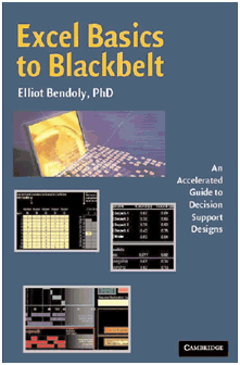 "Excel Basics to Blackbelt": A Reference Text for MapPoint Integration "Excel Basics to Blackbelt": A Reference Text for MapPoint Integration
Dr. Elliot Bendoly shares information about his new textbook which includes information about integrating Excel and MapPoint.
"On a daily basis,
professionals are expected to make decisions in fundamentally complex
environments. "Should I recommend that my client invest in a particular
developing region?" "Should I recommend an offshoring/outsourcing
scenario given my expectations of how other parties are likely to act
in the near term?" "Should I offer to take on additional work now that
one of my current projects appears to be nearing completion?" These
aren’t simple questions, and we can’t expect individuals faced with
such questions to always have immediate and appropriate answers
available to them. What we "can" expect is some level of thought, and
some level of a desire for assistance when good solutions are
particularly needed. Where this assistance comes from can vary, but,
being the eternal tool-builders that we are, we tend to find such
assistance in the form of data representation, analysis and
interpretation mechanisms built expressly for these purposes."
 Full
article text Full
article text  Discuss
this story Discuss
this story
 Routene Excel and MapPoint Update Routene Excel and MapPoint Update
John
Sewell introduces and explains the features in the latest version of
Routene, an Excel spreadsheet for of physical supply chain and
logistics applications. A full version of Routene is now available for
purchase.
"Because MapPoint can be
accessed programmatically either from VBA or any other programming
language it is possible to use MapPoint to solve a wide range of
physical supply chain questions. As part of our business -
supply chain consultancy - we have done a number of distribution
network strategies; with typical components being how many distribution
centres to have, where to locate them and the transport implications of
running them. We found that the off-the-shelf tools to solve
this are both expensive and completely ‘black box’ - providing an
answer but little explanation as to how the answer has been derived. So
we started to use MapPoint driven by Excel and created Routene as an
Excel add-in. Incidentally, we started in .NET but found response was
too slow and the framework cumbersome. Based on David Hager’s article
Excel User-Defined Functions and MapPoint, we started using VBA which
was both faster and much more flexible. Excel is the ideal place to put
results so you can do supplementary analysis with results; this is why
we view Routene as a toolkit rather than a ‘solution’." Full
article text Discuss
this story  Demo Software Download Demo Software Download | | advertisement
The
Virtual Earth platform represents an integrated set of services that
combines unique bird's-eye, aerial, and satellite imagery with
best-of-breed mapping, location and search functionality. It enables
companies to deliver innovative solutions and breakthrough customer
experiences. The Virtual Earth platform powers a variety of consumer,
enterprise and government applications. Take
your websites and applications to the next level by creating an
immersive online mapping and search experience. Consumers can easily
search, discover and visualize company location data and relevant local
information. If your app is stuck with flat, boring maps, click here
and we'll help you migrate. Locate. Integrate. Innovate. Are you ready?
|
|
| 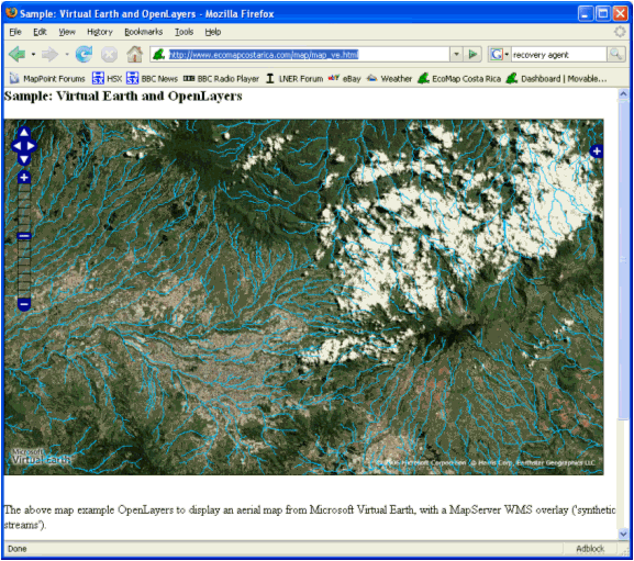 Using Virtual Earth with OpenLayers Using Virtual Earth with OpenLayers
This
article by Richard Marsden shows you how to create a Virtual Earth base
layer in an OpenLayers application. OpenLayers is an open source
Javascript project which receives the layer map data from one or many
different sources including WFS, Yahoo, WorldWind, Google, TileCache,
TMS, and GML.
"This article shows you
how to use Virtual Earth with OpenLayers. Our example is based on the
maps used by the EcoMap Costa Rica project ( http://www.ecomapcostarica.com
), and will overlay external data on a Virtual Earth base map. Of
course Virtual Earth has the ability to display a variety of formats on
a base map. However OpenLayers adds many more options. For example, our
overlay will be a shapefile that is supplied by MapServer as a series
of WMS tiles. OpenLayers also allows us to use different base maps as
appropriate. For the EcoMap Costa Rica project, Virtual Earth does an
excellent job of visualizing Costa Rica and Central America, but does
not currently have the detail required for the main area of study which
is less than 1km in extent. By using OpenLayers we can easily
re-arrange the layers to meet our specific needs. OpenLayers
is an open source Javascript project that can provide the client side
of a web map application. OpenLayers handles the map-keeping operations
such as zoom, pan, enable/disable layers, pop-up windows, etc. It
receives the layer map data from one or many different sources. Even
before we started to use different data sources, we found that
OpenLayers's AJAX capabilities greatly enhanced the user experience of
a MapServer map application." 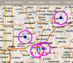 A Simple Add-in for MapPoint API Beginners A Simple Add-in for MapPoint API Beginners
Richard
Marsden's latest article shows step by step how to create a MapPoint
COM Add-in using Visual Basic to draw circles around pushpins. Includes
complete source code and screenshots.
"This "How To" article was prompted by AgDawg’s post on the MapPoint forums ( Drawing Multiple Radius Circles
). It is intended to show how to create a simple add-in that uses
Visual Basic 6 (VB6) – a part of Visual Studio 6. It also demonstrates
pushpin processing and simple shape drawing. Namely, it draws circles
of 30 miles radius around every pushpin in the ‘My Pushpins’ pushpin
set. VB6 might seem an odd choice for 2008. It is old. It is
creaky. Microsoft has recently withdrawn their support. Despite this,
much of the MapPoint programming documentation still uses it. It is
also easy to use with MapPoint’s COM interface. C# might be a much
nicer language with wonderful .NET bells and whistles, but writing a
MapPoint add-in using C# is always much more work than it should be. So
although serious developers should probably look at C++ or C#, VB6 is a
great entry point to learning MapPoint’s API and object model. It is
also cheap – Visual Studio is sufficiently out of date that sealed
unopened copies are no longer in demand."
advertisement
|
 |
Working
with pushpins in
MapPoint? Get the MapPoint Pushpin Tool for just $75. The
latest features include the ability to export lat/lon coordinates of
pushpins to Excel and advanced find Pushpin functionality. Read more
and purchase the tool here
or go
directly to paypal.
Affordable
volume
licensing
now available for
organizations wishing to distribute the Pushpin Tool to 5, 10, 20, or
50
or more users.
|
|
 The MapPoint Web Service Helper - Part II: Mobile Application Development The MapPoint Web Service Helper - Part II: Mobile Application Development
This
article describes how the MapPoint Web Service Helper can be used to
quickly and easily write Visual Basic 2005 mobile applications that
make use of the Microsoft MapPoint Web Service.
"This article is the
second of two that will be discussing use of the MapPoint Web Service
Helper. In this article we will be discussing how to develop a MapPoint
Web Service Visual Basic 2005 mobile application, making use of the
Helper, that could be deployed on a Pocket PC running Windows Mobile.
"Keep
in mind that although this article discusses the Helper in the context
of Visual Basic 2005 and the Helper was written in C#, the Helper can
be used with any of the more than 20 .NET languages currently in
existence. All files associated with the Helper library, including the
two PowerPoints can be downloaded by going to this link at the
Microsoft Academic Resource Center.
"The current version of
the Helper, completed during spring 2007, provides the following
methods: GetInstance, FindLocation, GetMap, GetMapURL, GetRoute,
GetRouteMap, GetRouteMapURL, GetRouteDirections, RouteItineraryToText,
FindNearbyPlaces, GetTrafficIncident, GetPostalCode, and GetAddress.
These methods were discussed in Part I using a series of small Visual
Basic 2005 applications, including four Windows and one Web
application. For each application, the Helper methods required by the
application were described, the Visual Basic code (replete with
comments) was provided, and a graphic showing the running application
was displayed. "
Full
article text Discuss
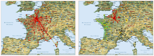
this story Handling Pushpin Collisions Handling Pushpin Collisions
Wilfried Mestdagh shares a solution for reducing the number of pushpins that must be displayed on a map
"The question often comes
up where thousands of pushpins must be displayed. However, nobody wants
thousands of pushpins on the screen. So if you get that task then first
rephrase the problem, that is: I have thousands pushpins, how do I make
a comfortable GUI ? "Displaying thousands of pushpins take
time. To avoid this you can only display the pushpins that are in view.
Another point is the collision. You really don't want to have an ugly
view of lots of pushpins overlapping each other. "In this
article we describe the most simple thing to avoid collision, that is
with sequentially positions as a route from a vehicle. In a future
article we describe other possible approach needed for non sequentially
positions. "You really don't want to display an ugly screen
like the one above. Instead you calculate the distance between each
pushpin, get the distance of 1 pixel, and leave preferable 20 pixels
between each pushpin. This must be recalculated at every pan or zoom of
the map."
Full
article text Discuss
this story | advertisement
Programming MapPoint in .NET
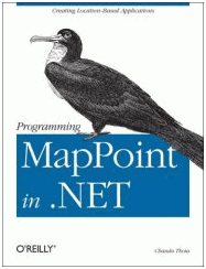 |
Chandu
Thota's New Book from O'Reilly Press
Free USPS Priority Shipping - $48
The
first and only book in print on programming MapPoint technologies. The
book includes sections on MapPoint 2004, the MapPoint Web Service,
MapPoint Location Server, and Virtual Earth. The books is 354 pages
chock full of programming examples and map screenshots. For example,
the book spends 40 pages discussing in depth the various Data Map
styles in MapPoint 2004, dissects the DisplayDataMap method in detail,
and has a number of examples of importing data from various sources.
There are over 100 pages on the MapPoint Web Service including sections
on the Find, Route, and Render API's. Inquire about
international shipping and multiple copy discounts.
Take your MapPoint programming to the next level!
Order Your Copy Today - Free Shipping!
| |
| The MapPoint Web Service Helper - Part I: Windows and Web Applications
This article describes how the MapPoint Web Service Helper can be used
to quickly and easily write Visual Basic 2005 Windows and Web
applications that make use of the Microsoft MapPoint Web Service.
"Programming with the
MapPoint Web Service directly can be extremely challenging and comes
with a significant learning curve. With this concern in mind, Martin
Schray, Central and Western US Academic Developer Evangelism Manager
for Microsoft, and I have collaborated on the development of the
MapPoint Web Service Helper. Martin has created the MapPoint Web
Service Helper Class Library, with ongoing discussions with me about
the functionality that it should provide. Meanwhile, I have developed
two PowerPoint presentations discussing how this library can be used in
developing Visual Basic 2005 Windows and Web applications.
"The
MapPoint Web Service Helper (we’ll call it the Helper for short) was
designed to provide an easy-to-use interface to the MapPoint Web
Service that doesn’t require a large learning curve. Many parameters
provided by the MapPoint Web Service are hidden from the user, and
returns from one method can be used to feed the next. You can find
locations, render maps, retrieve driving directions, find points of
interest (e.g. ATM, Banks, Gas Stations...) and even get real time
traffic information. Especially nice is the fact that you can do these
things for Windows, Web, and mobile applications with the Helper. In a
nutshell, the Helper significantly simplifies access to the MapPoint
Web Service Find, Render, and Route services by providing a simple API
with just a few core arguments."
Full
article text Discuss
this story Automating MapPoint in C++ With Built In GPS Features Enabled Automating MapPoint in C++ With Built In GPS Features Enabled
Jonathan
Oppelaar shows how he used techniques to overcome limitations in the
MapPoint API to make MapPoint a better navigation platform for
Project54, a in-car law enforcement system currently in use in over
1,000 vehicles.
"Project54 is currently
developing a GPS Navigation application to be used in police cruisers.
This navigation application is using MapPoint 2006 as its routing and
mapping engine. MapPoint 2006 has an SDK which gives developers
software control of MapPoint. With this SDK Project54 developers are
able to integrate MapPoint into the Project54 system. However, there
are a few limitations to MapPoint’s SDK that need to be resolved before
MapPoint can be installed in a car. The first limitation is that there
are no API calls to turn GPS Tracking on or off. GPS Tracking is a
MapPoint feature that reads data from a GPS receiver and displays your
current position on the map. This feature also has the ability to
rotate the map, which cannot be done via APIs. "Driving
Guidance is another MapPoint feature that cannot be controlled by the
SDK. Driving Guidance displays turn by turn directions while a user is
driving along a route. These directions are also presented to the user
through speech. A status bar is shown to keep the user up to date with
progress on a certain road segment. "These limitations must be
overcome if we want to use MapPoint as the navigation backbone in the
Project54 system. This article is about my workaround to MapPoint’s SDK
that allows developers to enable MapPoint’s GPS Tracking and Driving
Guidance."
Full
article text Discuss
this story Building an Animated Map with Flash Demo Builder John
Meyer shows how to create an animated Flash map using MapPoint and
Flash Demo Builder. This can be used for demonstrations and allows
interactive capability with the map.
"Flash Demo Builder program is very easy to learn and use and the price is a very reasonable $99.99.
"While
I’ve created this demo of driving directions showing a car traveling to
a specific location the possibilities for uses of this program are
many.
"Tutorials would seem to be the original purpose of such
a program but when combined with Map software such as MapPoint now you
are just showing off!
This program comes with demos of its own
to get you started with your first project and it really is very easy
to create demo from scratch. I started the Flash Demo Builder program
and choose New Presentation | Create from screen capture."
Full
article text Discuss
this story
|
Look forward to
upcoming issues in which we focus on recent MapPoint and Virtual Earth
news and share forum highlights.
Previous issues of
the MP2Kmag Update are available in
the newsletter
archive.
|
| Copyright
1999-2008 MP2K Magazine |
To subscribe to this newsletter and ensure you receive future issues
on your preferred e-mail address
send a blank e-mail to newsletter@mp2kmag.com with
SUBSCRIBE in the subject line.
Please forward this newsletter to anyone who would be
interested!
|