|
 Welcome
to another issue of the MP2Kmag
Update. In this issue we invite you to nominate your favorite MapPoint
addin or extension and share how you find the tool useful in your day
to day work. In an upcoming issue we will give you the opportunity to
vote in order to determine what are the most popular MapPoint addins or
extensions among our readers. Welcome
to another issue of the MP2Kmag
Update. In this issue we invite you to nominate your favorite MapPoint
addin or extension and share how you find the tool useful in your day
to day work. In an upcoming issue we will give you the opportunity to
vote in order to determine what are the most popular MapPoint addins or
extensions among our readers.Wilfried Mestdagh and Richard Marsden contributed articles on developing with MapPoint applications with Visual Studio 2010 and the new Windows 7 Location API respectively. We also feature a feature a series of similar maps created with the ESRI BusinessMap 5.0 software (now discontinued) and Microsoft MapPoint. MP2K Magazine is your source for independent news and information about MapPoint and Virtual Earth technologies and we also host the popular web forum for MapPoint users and developers (www.mapforums.com). This Issue's Contents at a Glance - MapPoint Addins and Extensions - Nominate Your Favorite! - Maps Created with MapPoint 2010 and ESRI BusinessMap 5.0 Side-by-Side - List of MapPoint 2010 API Changes - New Methods, Objects, and Properties - New MapForums Twitter Integration - Get Published in MP2K Magazine - MapPoint and Visual Studio 2010 Tutorial - Using the New Windows 7 Location API - Using MapCruncher with Google Maps - Making MapPoint and SQL Server Work Together Happy Mapping and please forward this newsletter to anyone who would be interested! |
||||||
|
advertisement
|
||||||
FeaturesMapPoint Addins and Extensions - Nominate Your Favorite!Since the inception of the MapPoint product, a great number of third-party tools, both free and commercial and have been developed for Microsoft MapPoint. In upcoming issues we will be exploring some of these in depth, but first we want to hear what you and other readers find most useful in your daily work. Post as a reply to this thread on MapForums to share your favorite MapPoint addins or tools. You must first be registered in the MapForums discussion board.  Maps Created with MapPoint 2010 and ESRI BusinessMap 5.0 Side-by-Side Maps Created with MapPoint 2010 and ESRI BusinessMap 5.0 Side-by-SideKathleen Gaiser, a Research Analyst for NAS Insights prepared this series of slides showing maps depicting the same data with both BusinessMap 5.0 and MapPoint 2010. ESRI discontinued the BusinessMap product earlier this year and it can no longer be purchased anywhere that I could find, retailers of the product are all sold out. Kathleen was looking for a desktop software mapping package to replace BusinessMap and came across Microsoft MapPoint. As part of her evaluation, she created a set of maps with both MapPoint and BusinessMap, trying to generally match the look of the old BusinessMap maps or improve them. What do you think? Take a look! - Top Ten National Metropolitan Markets for Dentists - Lansing, MI Regional Metropolitan Markets for Dentists - Deep South Region Beverage and Plastic Bottle Manufacturers - Area Within 20 and 40 Minutes Drive Time From Oklahoma City, OK - Target Area for Zip Codes - Percent Hispanic Ethnicity Breakdown By County Across the United States MapPoint 2010 API Changes The MapPoint Object Model has been updated significantly - the most since at least the 2002 version of MapPoint. For developers who haven't yet explored all the new features, we recap all the new Methods, Objects, and Properties introduced with MapPoint 2010. MethodsThe new methods for Microsoft MapPoint 2010 are:
ObjectsThe topics in this section give details about objects and collections by providing a graphic of the element's object model inheritance and an explanation of the object or collection. Also provided is a list of associated methods, properties, and events as applicable. The new objects for Microsoft MapPoint 2010 are:
PropertiesThe new properties for Microsoft MapPoint 2010 are:
MapPoint Consultants and Products Directories Find developers and experienced MapPoint consultants who can help you with your next project or program costum solutions helping to integrate MapPoint with your business processes. If you are a consultant who know MapPoint or Bing Maps, this is a terrific way to read our audience and share information about your capabilities, services, describe past projects, and communicate your availability. You are welcome to post your resume and keep your thread or profile updated periodically with references, new offerings, and contant information. Get started today by posting "New Thread" in the MapPoint Consultant Directory. Listings are free, but there is also an opportunity to become a sponsor for a more prominent listing and a link from the home page. New MapForums Twitter Integration Follow MapForums on Twitter! We frequently highlight new topics via our Twitter account "MapForums". We have also installed TweetBoard on MapForums, a toolbar which floats on the left side of the MapForums site, and pulls in a threaded view of Twitter conversations related to the MapForums posts. Check it out - go to www.MapForums.com, and click on the tab that says "tweets" on the left. Examples of recent posts in MapForums highlighted in Twitter and which appear in the TweetBoard: - Accessing Demographic Data Values - Retrieve US State from Directions - Matching Census Tracts...some match, some don't - Canadian mapping: FSA to CSD or the other way around - Drawing Lines Between City/State Pairs - Exporting with new information - MapPoint Europe And North America Twitter users - keep abreast of all MapPoint news and the community by following the MapForums twitter account.  Get
Published in MP2K
Magazine Get
Published in MP2K
MagazineIf you have a MapPoint presentation, neat programming technique, or would simply like to share the ways in which you are using MapPoint technology or any other ideas, contact us to discuss how we can turn your knowledge into an article and share your experience with the rest of the MapPoint community of users and developers. Thanks to Marvin Hlavac for allowing us to use the picture on the right of his Maltese puppy eating from the MapPoint mug. |
||||||
|
||||||
Articles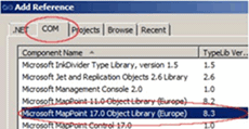 MapPoint and Visual Studio 2010 Tutorial MapPoint and Visual Studio 2010 TutorialWilfried Mestdagh shows how to get started with Visual Studio 2010 and MapPoint 2010 development in this first of a two-part article. "Sometimes people think MapPoint's architecture is getting dated and has difficulties working with modern development tools. Well, nothing is less true. Every modern development tool is perfectly suited to do development with MapPoint. This article is a small tutorial on how to start with MapPoint in VS2010, using the object model. "This article assumes you have installed Visual Studio 2010 and MapPoint 2010 (or any other version). "We start the development tool and create a new windows forms application. First thing to do is to add the MapPoint type library to our project." Using the New Windows 7 Location API Richard Marsden discusses the new “Location and Sensors” API and how to get started with development including a complete working example with source code available to download. "Probably one of the most interesting additions in Windows 7 for application developers is the addition of a “Location and Sensors” API. This provides a common interface for a wide range of sensor devices – ie. similar to a device driver for a printer. This will be very useful where such peripherals are often shackled to vendor-only applications and/or serial (RS-232) connections. Today, the only place where I actively use an RS-232 connection is in the daisy chain of cables and adapters that we have to take with us on the EcoMap Costa Rica Project (URL: http://www.ecomapcostarica.com ) in order to read data from our HOBO water temperature recorders! Closer to home, the geospatial world is still encumbered by the NMEA-0183 standard which is based on a serial (“COM port”) connection although it is usually implemented virtually. You only need to search the forums here to see the problems caused by this virtual COM port arrangement: users have to install a USB driver and configure “non-existent” settings like COM port and baud rate. They rightly expect to be able to plug their GPS device in and it “just works” – like a printer or any other USB device. These problems should go away as more people adopt Windows 7 and vendors roll out Location API drivers for their devices. This article shows you how to use the new Location API in your own application." 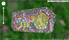 Using Microsoft MapCruncher with Google Maps Using Microsoft MapCruncher with Google MapsPreviously Richard Marsden demonstrated how to use Microsoft Research's MapCruncher tool to create map tiles from custom bitmaps for Bing Maps. This article shows you how to use MapCruncher tiles with Google Maps. "Recently I tried to implement a multi-touch interface for the EcoMapCostaRica.com maps so that they could be used on the Apple iPad and similar devices. At the moment, the Google Maps v3 API is the only web map API that supports multi-touch and is also supported by the Apple iPad. The Bing Maps Silverlight control has multi-touch support but it is unlikely that it will ever be supported by the iPad. "These maps are a conventional "pushpins and shapes on a map" application implemented using KML and (MapCruncher) tile overlays for satellite and aerial imagery. KML is easy to implement in Google Maps, but the MapCruncher tiles are a little more difficult." 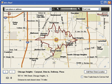 Making MapPoint 2010 and SQL Server Spatial Work Together Making MapPoint 2010 and SQL Server Spatial Work TogetherAfter Bing Maps, two of the most visible geospatial technologies from Microsoft are Microsoft MapPoint 2010 and the spatial functionality in SQL Server 2008 R2. However, even though SQL Server is an ideal store for geospatial data, and MapPoint makes a good geospatial viewer, communicating between the two is not nearly as straightforward as it could be. "This article will demonstrate how to read point and polygon objects from SQL Server and render them in MapPoint. We’ll also demonstrate how to write points and polygons back to SQL Server using the Entity Framework 4.0 included with Visual Studio 2010. "For purposes of illustration, we’ll be using the “Al’s Beef” Chicago-based company’s restaurant locations and hypothetical trade areas. In retail analysis and modeling, trade areas can be defined using various parameters and can be used for different aims. Typically, they’re defined as the smallest region around a store that contains areas that meet a specific threshold—for example, where 50 percent or 75 percent of customers live or work." |
||||||
|
advertisement
|
||||||
| Look
forward to
upcoming issues in which we focus on recent MapPoint and Bing Maps
news and share forum highlights. Previous issues of
the MP2Kmag Update are available in
the newsletter
archive. |
| Copyright 1999-2011 MP2K Magazine |
Please forward this newsletter to anyone who would be interested!


