Eric
Frost, Editor
|
| advertisement
|
MapPoint
2006
MP2Kmag
is pleased to offer MapPoint 2006 along with our Routing and
Programming Tools Spreadsheet ($95 value) for just $259.
There
are again two versions, North America and Europe and the maps are
updated with the most recent digital map databases. Other new features
include:
- integration with Windows Live Local and the Locate Me
feature -
a new Night-time map style and other driver guidance
features
- Navteq streets and a TON more data for the European version Free
Priority Shipping within the United States.
Update your MapPoint maps to the latest digital map databases!
| |
| |
|
Features
 Automating
MapPoint with Excel VBA - Tutorial 5 Automating
MapPoint with Excel VBA - Tutorial 5 In
this installment of the tutorial series on programming MapPoint with
Excel we should how to loop over a series of addresses and plot
pushpins and draw radius circles around each location. Earlier
tutorials can be found here 1,
2,
3,
and 4.
To get started with this tutorial, download
the spreadsheet with VBA code. The code works with MapPoint
North America and the sample data is for the North American version,
but it can be easily modified for MapPoint Europe. Let me know if you
would like help with this and I will post it in the discussion area for
the tutorials. The main portion of the code is a
loop. The program looks for a list of addresses on the spreadsheet
stops when it finds the first blank line. Further comments are found in
the code below.
szAddress = Cells(nCurrentRow, 3)
Do While (szAddress <> 0) 'stop when it reaches
a blank line.
'read line from spreadsheet and assign to variables
szName = Cells(nCurrentRow, 2)
szCity = Cells(nCurrentRow, 4)
szState = Cells(nCurrentRow, 5)
szZip = Cells(nCurrentRow, 6)
nRadius = Cells(nCurrentRow, 7) 'column G
'find the address and add a pushpin to the map
Set objFindResults = objMap.FindAddressResults(szAddress, szCity, ,
szState, szZip)
Set objLoc = objFindResults(1)
Set objPushpin = objMap.AddPushpin(objLoc, szName)
'draws circle based on radius in column G
objMap.Shapes.AddShape geoShapeRadius, objLoc, nRadius, nRadius
'pop up pushpin name
objPushpin.BalloonState = geoDisplayName
nCurrentRow = nCurrentRow + 1
szAddress = Cells(nCurrentRow, 3)
Loop
If you have any questions,
suggestions, or enhancements you would like to share please post in the
MapPoint
/ Excel VBA discussion thread. Keep an eye out for
a continuation of this series in future issues.
MapVisitors.com Virtual
Earth Webmaster Tool MashupThe
MapVisitors application was first mentioned in this newsletter back in
2005 has now been moved to its own web site at www.mapvisitors.com.
MapVisitors is a free tool for web sites to generate a worldwide map
of their visitors.
Additional features to be added soon include a color-coded map at low
resolutions to more clearly depict concentrations of visitors, ability
to use custom graphics, improving the layout and look of the map, and
more -- send us your feature requests. This is the html code to paste
into your web site layout -- <a
href='http://www.mapvisitors.com/' title='Map of
Visitors'><img src='http://www.mapvisitors.com/m.png'
alt='IP Map' style='border:0'></a>If
you would like a custom graphic that uses a different button or image
that better fits into your web site design, send it to me and I will
get it ready right away and provide you with the new html code. Inquire
about a custom implementation of this tool for your web site.
 Get
Published in MP2K
Magazine Get
Published in MP2K
Magazine
If you have a MapPoint presentation, neat programming technique, or
would simply like to share the ways in which you are using MapPoint
technology or any other ideas, contact us to discuss how we can turn
your knowledge into
an article and share your experience with the rest of the MapPoint
community of users and developers.
Thanks to Marvin
Hlavac for allowing us to use the
picture on the right of his Maltese puppy eating from the MapPoint
mug. |
| advertisement
The new standard for route
optimization
Don’t miss the sign
to get your fleet operations on the right track.
With TourSolver for
MapPoint
you can easily plan & optimize your delivery routes, sales
& service calls for your entire workforce. TourSolver
calculates stop sequence for your fleet while taking over 60
constraints into account.
Start reducing unnecessary
mileage, & fuel usage today. |
|
|
| Articles
 Using Virtual Earth to Write a Vista
Gadget That Tracks the International Space Station Using Virtual Earth to Write a Vista
Gadget That Tracks the International Space Station
This
is the second of a two article series about writing Vista
Gadgets that use Virtual Earth. The first article ("Using Virtual Earth
in a Vista Gadget") showed you how to write a Vista Gadget that showed
a simple interactive map using Virtual Earth. This second article
extends the gadget into something more useful: A Tracker for the
International Space Station (ISS)
"At
start up, the gadget automatically downloads the latest orbital
parameters from the AmSat website. The map is updated every half second
with the ISS’s latest position. The position is tracked with a pushpin
shaped like the ISS. The map automatically pans to keep the ISS
centered in the map. The user may zoom in or out using "+" and "-"
buttons. A "Refresh" button allows the orbital parameters to be
refreshed from AmSat. These orbital parameters should only be refreshed
every few days -- you do not need to do this if you restart Vista (and
hence the gadget) on a daily basis. Instead of two files, the
gadget now contains ten files. One of these is an image: ISS_pin.gif
stores the image of the ISS pushpin. The remaining extra files
(global.js, graphic_clock.js, math.js, sgp4sdp4.js, time.js, utils.js,
view.js ) are all JavaScript files used to calculate the orbit of the
ISS. These are based on the orbit calculation routines available from http://www.movingsatellites.com."
 Full
article text Full
article text  Discuss
this story Discuss
this story  Download
code Download
code
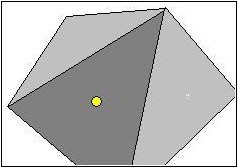 Determing Whether A Point Is Located
Inside Polygon Determing Whether A Point Is Located
Inside Polygon
Wilfried Mestdagh wrote this article on determing whether a vehicle is
located inside or outside a convex polygon. "Simplify the polygon by
make triangles from it one by one, until we have a triangle where the
point is inside. At the end we only have to verify if the point is in
the last triangle."
"This
article explains a method to calculate if a position is in or
outside a convex polygon. It does not make use of floating point
numbers to optimize for speed as much as possible. To transform
Latitude / Longitude pairs into X/Y coordiantes, just multiply them
with a given factor, for example 100000. 1/100000 of a degree gives
precision of around 1 meter which is already better than any GPS
receiver. To
make the calculations easy we will reduce the polygon to triangles by
replacing each time two successive sides by a new one, provided that
the triangle formed by the two polygon sides and the new side does not
contain the point." Full
article text Discuss
this story Download
code | | advertisement
The
Virtual Earth platform represents an integrated set of services that
combines unique bird's-eye, aerial, and satellite imagery with
best-of-breed mapping, location and search functionality. It enables
companies to deliver innovative solutions and breakthrough customer
experiences. The Virtual Earth platform powers a variety of consumer,
enterprise and government applications. Take
your websites and applications to the next level by creating an
immersive online mapping and search experience. Consumers can easily
search, discover and visualize company location data and relevant local
information. If your app is stuck with flat, boring maps, click here
and we'll help you migrate. Locate. Integrate. Innovate. Are you ready?
|
|
|  Using Virtual Earth in a Vista Gadget Using Virtual Earth in a Vista Gadget
Richard
Marsden shows how to configure a Vista Gadget to pull from
Virtual Earth. "Vista gadgets are simply HTML files, and are hence very
easy to write."
"A
feature of the new Vista operating system that has been seeing a lot
of recent attention, is that of Gadgets. Vista Gadgets are small
programs that sit on the desktop. Samples that come with Vista include
RSS feeds, a clock, and simple games. This article is the first of two
articles. In this first part, I will show you how to write your own
Vista Gadgets that use Microsoft’s Virtual Earth platform. The second
part will build on this to produce a gadget that continuously tracks
the position of the International Space Station over the Earth’s
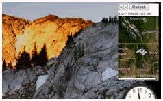
surface. The following screenshot shows two Gadgets installed
on a Vista desktop running the Aero visual interface. The lower gadget
is the standard Vista clock. The upper gadget is the Virtual Earth
gadget that we will create in this article. The gadgets are in the
Windows sidebar. If your sidebar is disabled, it can be enabled by
clicking "Windows Sidebar" in Start->All
Programs->Accessories."
 An API to Control MapPoint 2006 GPS
Features - Part I of II An API to Control MapPoint 2006 GPS
Features - Part I of II
Paul Larson shares an API he developed to add programmatic GPS
functionality to MapPoint code projects and includes a demo to
illustrate how the API works.
"With
the release of MapPoint 2006 North America (MP2K6NA) earlier this
year, many users have been elated with the new map content and the
addition of GPS features and Driving Guidance to the product. Likewise,
many developers have thus found issue with the lack of improvement to
the MapPoint API, specifically in relation to these new features. Being
of the latter group, I decided to roll-my-own API to add programmatic
GPS functionality to my MapPoint code projects. Part
I of this project will simply encapsulate the standard UI for
GPS tracking, centering, rotation, Driving Guidance and GPS-trailing
functionality, along with some UI state detection."
advertisement
|
 |
Working
with pushpins in
MapPoint? Get the MapPoint 2004 Pushpin Tool for just $75. The
latest features include the ability to export lat/lon coordinates of
pushpins to Excel and advanced find Pushpin functionality. Read more
and purchase the tool here
or go
directly to paypal.
Affordable
volume
licensing
now available for
organizations wishing to distribute the Pushpin Tool to 5, 10, 20, or
50
or more users.
|
|
Using MapPoint and Excel for Supply
Chain Management
John Sewell submitted this 3000 line application developed using
MapPoint and Excel which performs a number of functions related to
Supply Chain Management.
"Attached
is an Excel Add-in called RouteneXL. It operates by directly
linking with Mappoint and contains lots of code using both Excel
& MapPoint functionality. As part of our business -
supply chain consultancy - we have done a number of distribution
network strategies; with typical components being how many distribution
centers to have, where to locate them and every question associated
with them. To support this - and reduce the cost of off-the-shelf
network modelling software - my colleague, Jon Nicholas, and I have put
together a tool kit to support network planning. I
have attached the add-in. We would really be interested in any comments
and improvements."
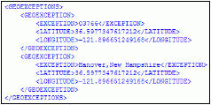 Creating Geocoding Exceptions for
MapPoint Web Service Applications Creating Geocoding Exceptions for
MapPoint Web Service Applications
Stephen
Pushee wrote this article on resolving geocoding exceptions
when using the MapPoint Web Service. "For example, a user might supply
St. Thomas as a city name when searching for St. Thomas the island, not
knowing that Charlotte Amalie is the main city on St. Thomas."
"In
many MapPoint Web Service applications, a user
supplies a postal code or city name, which is then sent to
MapPoint Web Service to be geocoded (assigned
latitude and longitude coordinates). At times, you may need to override
the geocode provided by MapPoint Web Service or
provide a geocode for an entity that the geocoder does not recognize...
You can work around this issue by using a GeoException.
A GeoException is an object consisting of a name
(usually a postal code or city) and its corresponding latitude and
longitude. By compiling a list of GeoException
objects and making that list available in your application, you can
ensure that your application returns the results that you expect."
Full
article text Discuss
this story Download
code | advertisement
Programming MapPoint in .NET
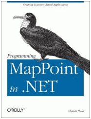 |
Chandu
Thota's New Book from O'Reilly Press
Free USPS Priority Shipping - $48
The
first and only book in print on programming MapPoint technologies. The
book includes sections on MapPoint 2004, the MapPoint Web Service,
MapPoint Location Server, and Virtual Earth. The books is 354 pages
chock full of programming examples and map screenshots. For example,
the book spends 40 pages discussing in depth the various Data Map
styles in MapPoint 2004, dissects the DisplayDataMap method in detail,
and has a number of examples of importing data from various sources.
There are over 100 pages on the MapPoint Web Service including sections
on the Find, Route, and Render API's. Inquire about
international shipping and multiple copy discounts.
Take your MapPoint programming to the next level!
Order Your Copy Today - Free Shipping!
| |
|
|
Look forward to
upcoming issues in which we focus on recent MapPoint and Virtual Earth
news and share forum highlights.
Previous issues of
the MP2Kmag Update are available in
the newsletter
archive.
|
| Copyright
1999-2007 MP2K Magazine |
To subscribe to this newsletter and ensure you receive future issues
on your preferred e-mail address
send a blank e-mail to newsletter@mp2kmag.com with
SUBSCRIBE in the subject line.
Please forward this newsletter to anyone who would be
interested!
|