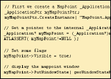
Click here to view this issue online
Click here!
 Wednesday - January 12, 2005
What's New at MP2K Magazine 
Welcome to another issue of the MP2Kmag Update. At the top of the news, Microsoft announced yesterday a new MapPoint product for fleet tracking applications - MapPoint Fleet Edition 2004. The only difference with MapPoint 2004 is the license - the functionality and data are the same. Licenses for the Fleet Edition product are only available through the ISV-R and volume licensing programs, it will not be available through retail channels.

The primary change in the license is that the per-vehicle requirement is removed in the Fleet Edition. A remaining restriction, however, is that the product cannot be used to provide real-time vehicle guidance i.e. turn-by-turn driving directions in concert with a GPS. While it would have saved partners a lot of confusion and stress if Microsoft could have negotiated with the data providers to release a product like this a couple years ago (i.e. back when they were still known as Navtech ;-), it is still a welcome move and presents an opportunity for partners who develop for this market.

MP2K Magazine is your source for independent news and information about MapPoint technologies and products and is home to the popular web forum for MapPoint users and developers. This month we feature an article from Laura Cramb on creating an Add-in for MapPoint using Visual Studio .NET and another article from Arthur Hefti on developing with MapPoint and Powerbuilder.

Given the already long length of this issue, we have decided to forgo the MapPoint and Excel tutorial that we ran the previous two issues. However, the latest installment will be sent shortly (within the next week) to the new MapPoint E-mail Discussion List and the next installment will appear as normal in this newsletter.

This Issue's Contents at a Glance
 - features: New MapPoint E-mail Discussion List, 2004 Article and Newsletter Recap
 - articles: MapPoint Get MSAs Visual Studio .NET Add-in, Using MapPoint in PowerBuilder, Mapping Earthquake Aftershocks
 - news: Caravel, VRP for Vehicle Optimization, Terraviewer for MapPoint, MileCharter, Reverse Geocoding, Geography Olympics
 - forum: Forum Highlights, Google Search Tool, Nearly 10,000 topics and Over 1,600 Registered Users

Happy Mapping and please forward this newsletter to anyone who would be interested!

Eric Frost, Editor
advertisement

SpatialPointMake MapPoint Work Harder for You

Extend MapPoint’s functionality. Add new data layers and menu items. Get expert technical assistance and training. Develop more robust applications. SpatialPoint is staffed with MapPoint and spatial technology experts. We’ve built our business helping customers make the most of MapPoint platforms. From MapPoint 2004 to MapPoint Web Service, from locator applications to decision-support, we’re your source for all matters MapPoint.

Visit www.spatialpoint.com or call toll-free 866.846.5900.


Features

New E-mail Discussion List for MapPoint Technologies

We set up an e-mail discussion list for MapPoint. While not intended to be a replacement for the web forum, the e-mail discussion list format lends itself to a more immediate, and spontaneous exchange than occurs in the forum.

Sign up by sending an e-mail to list-bot@mp2kmag.com with the subject "SUBSCRIBE" or click here and hit send. Reply to the confirmation request that you will receive after a couple minutes, and then send an introduction to list@mp2kmag.com. See the news section below and let us know your score in the Geography Olympics Challenge -- both with and without resorting to looking up countries with MapPoint 2004. Have fun!

Large MapPoint MugWrite for MP2K Magazine in 2005

If you have a MapPoint presentation, neat programming technique, or would simply like to share the ways in which you are using MapPoint technology, or any other ideas, contact us to discuss how we can turn your knowledge into an article and share your experience with the rest of the MapPoint community of users and developers.

Writers often plug their consulting service or other business interest through their bio which appears at the bottom of the article. Others do it for the Large MapPoint Mug (see right!). Whatever the reason, it is rewarding to share and take credit for the knowledge you share with the rest of the community.

2004 Article Recap

We are pretty excited about the quality and quantity of the MapPoint-related content that we published last year and look forward to bringing you even more MapPoint articles, news, tips, solutions, etc. in 2005.

MapPoint Location Server FAQ
This document aims to answer frequently asked questions regarding the MapPoint Location Server such as system requirements, privacy issues, and the licensing model

Investigating the MapPoint Web Service 3.5 SDK
We take a look at getting started with the MapPoint Web Service including how to obtain an evaluation account, set up your computer with the right software, and run the Core Functionality samples both on your local computer and an ASP.NET web server

Lannon Fire DepartmentUtilizing MapPoint for Emergency Services
Mike Mueller of the Lannon Fire Department in Wisconsin discusses the opportunities and challenges in implementing MapPoint 2004 for a small village's volunteer fire department

Interview with Steve Lombardi
msmobiles.com recently caught up with Steve Lombardi in Cannes, France to discuss the soon-to-be-announced MapPoint Location Server

Determing the Time Zone in MapPoint
Leon Schell shares a method for determining the time zone by accessing hidden POI information

Programming with MapPoint 2004 using the .NET Framework
This article by Chandu Thota discusses how to program with the MapPoint 2004 object model using the Microsoft® .NET Framework

Calling MapPoint From C++Calling MapPoint From C++ Without the MFC Safety Net
Richard Marsden shows you how to access the MapPoint COM interface from C++ without using MFC. The code has been tested with Visual C++, Intel C++ Compiler, and C++Builder.

Microsoft Location Server Integration: A Project Manager's Perspective
MLS, being a Web service, is pretty straightforward from a programmer's perspective. But for a project manager, there can be other tricky issues. Here's a peek at a real-world project.

Using Geographic Codes to Import Data into MapPoint 2004
Greg Slayden of Microsoft shows how to use standard geographic codes (FIPS, NUTS, ISO-3166, and Canadian SGC) to import data files into Microsoft MapPoint 2004

Pocket Streets 2005Microsoft Pocket Streets 2005 FAQ
Pocket Streets 2005 offers map guide functionality for Windows Mobile Devices. This software makes it possible to create customizable maps, prepare complete itineraries, and locate places of interest such as restaurants, ATMs, shopping centers, transportation, tourist attractions and more.

With Microsoft’s MapPoint Division, Location is Everything
Q&A: Microsoft recently released Streets & Trips 2005 with GPS Locator, a new consumer mapping and trip planning package that includes the company’s first Global Positioning System device. Michael Graff, leader of the MapPoint Business Unit, shares the company’s vision for the future of location-based technology.

Plotting Earthquake Hazard Data in MapPoint
This two-part article by Richard Marsden shows how to use MapPoint to produce maps of earthquake hazards and to overlay recent earthquakes using data from the USGS. The technique of depicting data using grids can be used in a wide range of environmental and commercial applications.

Programming with Microsoft MapPoint Location Server, Version 1.0
Chandu Thota takes a first look at Microsoft MapPoint Location Server anddemonstrates how to develop powerful location-based applications and services usingMapPoint Location Server and MapPoint Web Service

advertisement

Linxoft Solutions, Inc.
Franson Technology AB


Microsoft Corp. SpatialPoint

Book this year's ads at last year's rates - only through January 31st!

Visit www.mp2kmag.com/ads or call 312.399.1586 to start your campaign.


Articles

Get MSA's MapPoint Get MSAs Add-in

Learn how to create a MapPoint add-in by using the MapPoint object model and Microsoft Visual Basic .NET. With the add-in, users can query Pushpin sets to find out if any of the Pushpins are located within Metropolitan Statistical Areas (MSAs). The add-in then displays the query results in a Microsoft Excel workbook.

"A Metropolitan Statistical Area (MSA) is a geographical area, defined by the federal Office of Management and Budget (OMB), that represents the metropolitan area of a city. In most of the United States, an MSA consists of a county or a group of counties.

MSA information can be useful in business planning, and the Get MSAs add-in provides an easy way for MapPoint users to extract and use the MSA information that is built into MapPoint. Suppose you have a list of 20,000 potential customers and want to figure out which ones to target for a sales campaign. You can import your customer list into MapPoint, and then use the Get MSAs add-in to query your Pushpin set and create a list of customers that are located within MSAs. You can then target your sales efforts to customers located in specific MSAs, based on demographic data provided by MapPoint."

  More Full article text Discuss Discuss this story


PowerBuilder Using MS MapPoint in PowerBuilder

Why should you use GIS (Geographic Information System) data in PowerBuilder? You can plan a route for a service technician or a sales person. You can track the positions of the trucks delivering goods and it might allow you to direct a truck to an additional pick up close to its route. You can print driving directions when heading to an unknown place.

"The following article demonstrates how to use the Microsoft MapPoint control from within PowerBuilder to perform such operations.

The MapPoint object model contains a lot of objects, but we'll use only a few. Figure 1 shows a section of the MapPoint control. The direction object is located in the upper half of the window and the map object at the bottom. There's a route on the map object that connects two waypoints and a pushpin that shows some information in a balloon. The control contains invisible objects as well, like the FindResults collection and a location object."

  More Full article text Discuss Discuss this story

Plotting the Aftershocks of the Great Sumatra Earthquake

Richard Marsden has already prepared maps plotting the aftershocks of the Great Sumatra Earthquake. Click on the maps below to read more and see the full-size map.

Sumatra Earthquake Sumatra Earthquake

Submit an article for publication and receive a free Large MapPoint Mug!


MapPoint News

Caravel - Microsoft's Next Generation Platform for Mobile Mapping
Steve Lombardi discussed "Caravel", MapPoint's next generation platform for maps and navigation on mobile devices, at a recent WE-DIG user meeting on Microsoft's campus. Steve Lombardi is the MapPoint Technologist Evangelist and he also presented information about the MapPoint Location Server.

MapPoint Technology May Be Featured in New MSN Search
From ClickZ News - "Microsoft is expected today to take the wraps off the beta of its new search engine, which incorporates natural language, local and personalized search features. The new search engine -- which lets users select tabs for Web, images, news or music searches -- is the result of two years of development work at the software giant." Microsoft will likely "continue to build its own proprietary content -- such as from Microsoft Money and Microsoft MapPoint -- into the search engine."
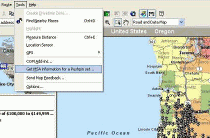
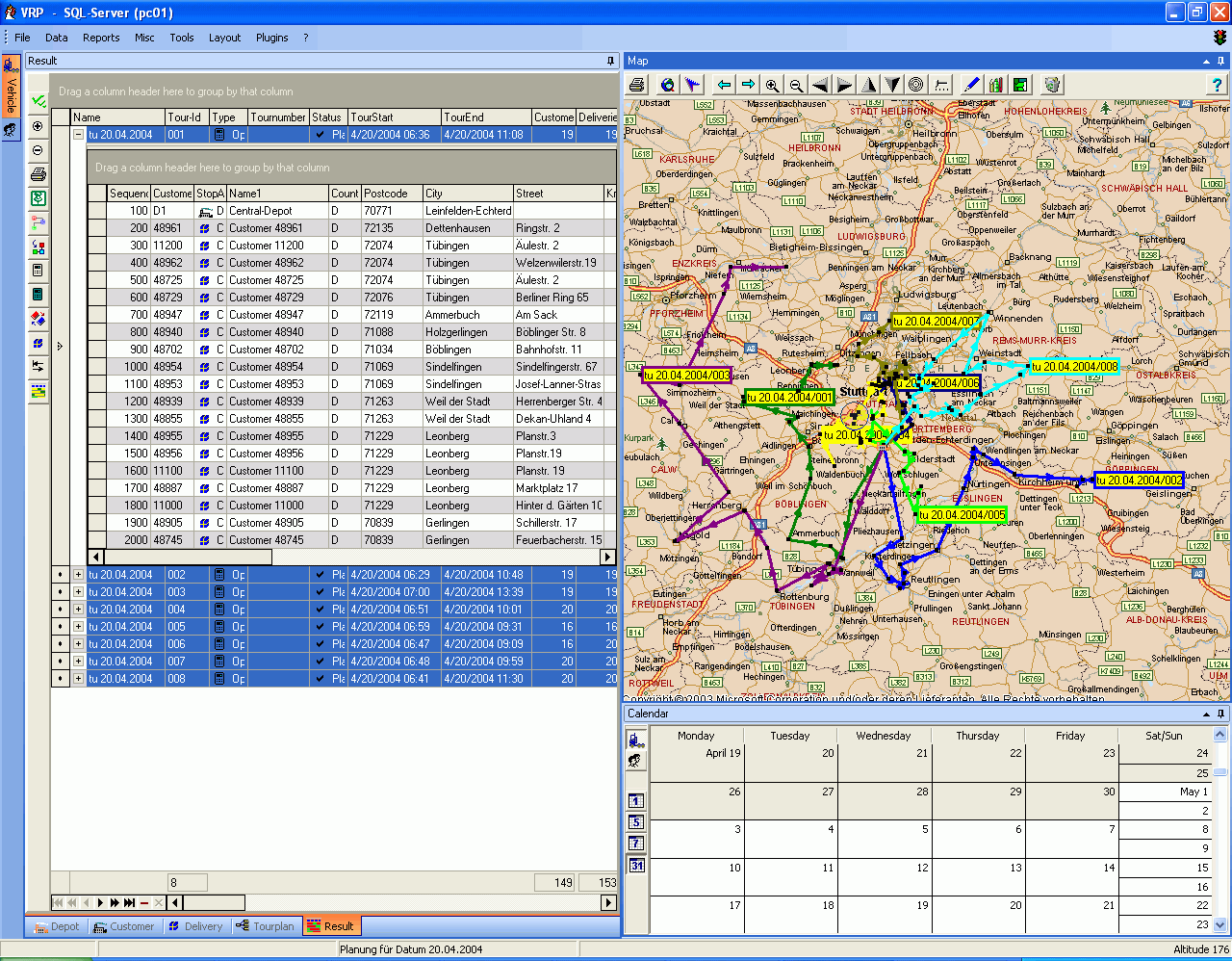
VRPVRP for Vehicle-Optimization Released
"Based on MapPoint we developed VRP for vehicle-optimization. VRP will help you in the daily work of planning and dispatching your milkrun-tours. The input-data as customer, delivery, vehicle and driver are stored in a database and can be imported via the import-wizard from Excel-files." Click the thumbnail on the right to view a full screenshot.

TerraViewer for MapPoint BETA Available
TerraViewer is an add-on to Microsoft MapPoint 2002 (and above) that integrates the TerraServer USA web service seamlessly into the MapPoint North American Maps desktop product. The product enables end users to view terabytes of United States Geological Survey (USGS) archived aerial photography and sixteen color topographic maps locally on their desktop via a simple user interface directly within MapPoint.

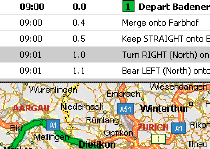
Winwaed Announces MileCharter for MapPoint
Winwaed Software Technology released their MileCharter add-in for MapPoint. MileCharter is capable of automatically calculating mileage tables and charts including route distances, travel times and estimated costs. Output is in the form of an Excel spreadsheet.

Chandu Thota's Top 10 MapPoint Moments of the Year 2004
"With only a few hours left in this year 2004, I thought it would be fun to look back and list out top 10 “MapPoint Moments” of the year. The following list is what I could come up with (in chronological order)..."

Mobile GPS Online releases GPSTrack Version 4.0.0
Mobile GPS Online announced the release of GPSTrack Standard Version 4.0.0. GPSTrack is a powerful yet low-cost vehicle tracking and management system. GPSTrack version 4.0.0 is a combination of the GPSTrackP software for GPS passive tracking and GPSTrackRT software for real time tracking.

KMSKMS Systems Enhances Security with GeoDoors
Monitoring of security operations has now come into the Network Operations Center (NOC) as a key to insuring network reliability and uptime. As the scope of work in the NOC has expanded, the need for intuitive interfaces has increased. KMS Systems Inc, known for its custom computer-based Access Control Systems, recognized this and has integrated operation and monitoring of physical security with Microsoft MapPoint 2004.

Reverse Geocoding DLL
"Having worked on Mappoint from MP2000 and still reading about people needing to get the Street / Town / Postcode etc from Coords. We have created a DLL that can be called from any application. It works with MapPoint Europe and MapPoint North America."

M.J. Menefee Construction Wins Constructech Vision Award
"Bidhistory.com provides a fast, direct method to get reliable starting numbers I can tweak." Menefee further refines his numbers for his cost estimate using The Dispatcher's mapping capabilities backed by Microsoft MapPoint. Knowing the exact distance and route from any haul origin to any jobsite gives me accurate costs to enter into my bid."

MS Smarter Hospitality Provides Comprehensive Framework
Microsoft Corp. announced Smarter Hospitality, a comprehensive solutions framework designed to help lodging and foodservice organizations dramatically improve the way they interact with their guests and operate while meeting the expectations of digitally enabled guests and employees.

More Countries Digitized with Universal Addresses
NAC Geographic Products Inc. has announced that Australia, Greece and Slovakia have been added to the countries digitized with Universal Addresses and Natural Area Codes raising the number of the Universal Address digitized countries to 22.

Finally, in the Putting MapPoint Technology to Good Use Category --
UK Pub Finder
"This page is a demonstration of Microsoft MapPoint. It searches the pubs recommended by The Good Pub Guide and also those pubs suggested by its readers."

Submit your press release or news item!

Microsoft and Technology News

The Geography Olympics
I originally spotted this site being mentioned on the MapInfo-L discussion list - www.geographyolympics.com. Let us know how you do! Join the new beta e-mail discusion list by sending an e-mail to list-bot@mp2kmag.com with the subject line "SUBSCRIBE" and e-mail your score to list@mp2kmag.com.
advertisement
Pushpin Tool
Working with pushpins in MapPoint? Get the MapPoint 2004 Pushpin Tool for just $75. The latest features include the ability to export lat/lon coordinates of pushpins to Excel and advanced find Pushpin functionality. Read more and purchase the tool here or go directly to paypal.

Affordable volume licensing now available for organizations wishing to distribute the Pushpin Tool to 5, 10, 20, or 50 or more users.


Forum Highlights

Some notable posts and solutions from the forum over the past couple months are listed below. Keep up with the latest news and information about MapPoint by bookmarking the forum and visiting regularly. There are now nearly 10,000 posts and in the forum and over sixteen hundred registered users.

We are presently looking for a web/template designer to redesign this portion of the site and actually have a small budget to accomplish this. If your are up to tackling the job and would like to earn a few bucks, drop us an e-mail!


Monday, January 10th

Gray other countries [1 reply]
Installation ISSUES. Please Help
About Error 4-40028-1. Error or Bug ? [9 replies]
Linking requests from Access [1 reply]

Sunday, January 9th

Map Updates
Problem with Parsing Countries [5 replies]
How to get the Best Matched Address from FindAddressResults. [8 replies]

Saturday, January 8th

Linking points [2 replies]
How to find out [1 reply]
Just Hand it to me [3 replies]
Permantly expand the icon file.
Stop The Dancing Maps [1 reply]

Friday, January 7th

Outlook calendar to MapPoint...
Pushpins [1 reply]
Help! Import Custom Symbol Array [2 replies]
Access and MapPoint control _really_ slow [2 replies]
D-GPS [1 reply]
Address Searching

Thursday, January 6th

My postal code
Importing ESRI Shape Files (.shp) [1 reply]
How to import detailed Mexico data [1 reply]
Install problem with my laptop !
MapPoint Gets closed on its own [11 replies]
Using MP2004 with Delphi [12 replies]

Wednesday, January 5th

Almost realtime vehicle position in MP2004
Possible to deploy a standalone C# MapPoint application ? [3 replies]
MapPoint 2005 [1 reply]

Tuesday, January 4th

It is possible to orientate the map [2 replies]
Plot history of vehicle [4 replies]
Is there way to check if you're on a road [1 reply]

Monday, January 3rd

Plot history of vehicle
MapPoint in The Netherlands [1 reply]

Sunday, January 2nd

Mappoint routing for Commercial Trucks [3 replies]

Friday, December 31st

I get this following error [3 replies]

Thursday, December 30th

MapPoint Control in Web applications [1 reply]

Wednesday, December 29th

Importing Vector digitalized map into MapPoint :?:
Territory Creation – Customized & Flexible
Streets & Trips vs. MapPoint [1 reply]
Embedding MapPoint Install Process in Our Software Install [1 reply]
geoImportAccessQuery problem [1 reply]
AGPS [4 replies]

Monday, December 27th

How to programatically tell if an address is located? [5 replies]

Sunday, December 26th

How to set Culture info in VB6+ASP+MapPoint Webservice

Saturday, December 25th

Importing data using State Plane X & Y Coords [2 replies]

Friday, December 24th

MapPoint snap to road [1 reply]
Center Map to a pushpin? [1 reply]

Thursday, December 23rd

Queens, New York Addresses [5 replies]

Wednesday, December 22nd

In car navigation for MapPoint 2004 [1 reply]

Tuesday, December 21st

Importing Lat and Long directly to Pushpin Dataset? [1 reply]
Convert MapPoint graphics to shapefile export [1 reply]
How to destroy all instances of MapPoint controls ? [4 replies]
question about MapPoint [3 replies]
Shape.addLine(loc1, loc2) -> How 2 Change size of line ?? [4 replies]
PocketPC Integration [2 replies]

Monday, December 20th

How to change the pushpin programmatically ? [4 replies]
How to send events to the MapPoint Control (in C#) ? [3 replies]

Sunday, December 19th

MapPoint for India [1 reply]

Saturday, December 18th

Pocket Map 2005 Voice directions prompting?
Geocoding into a database [1 reply]

Friday, December 17th

ZIP code updates??? [1 reply]
Delete Pushpin from PushpinSet (or DataSet) prior to moving [2 replies]
This forum is GARBAGE !!! [4 replies]
DisplayDataMap in Delphi 7
3-D Mapping [1 reply]

Thursday, December 16th

MapPoint control for Win CE.NET development (x86) [1 reply]
Exporting Data from MapPoint
MapPoint 2004 Geocoding [3 replies]
I loose a lot of street names with ObjectsFromPoint(X,Y) [2 replies]

Wednesday, December 15th

c# zoom to object [4 replies]
VB6/ACCESS DB/.LinkData/.UpdateLink
MapPoint examples [1 reply]

Tuesday, December 14th

Printing a Banner of MapPoint Maps [1 reply]
Error opening ptm file [3 replies]
Server is Busy [1 reply]
Reverse Geocoding at different Zooms
MapImage average byte size [1 reply]

Monday, December 13th

UpdateLink / PushPins / Access DB / HELP!!!
Automate large list of drive time & distance calculation [1 reply]
Hiding population places? Is this possible
How to Calculate 2 itineraries without clearing ActiveRoute [2 replies]

Sunday, December 12th

Returning your Lat/Long in mappoint
Chaptu [1 reply]

Saturday, December 11th

Use icon other than pushpin [1 reply]
Rendering graphics on top of the MapPoint Control

Friday, December 10th

Mapping Distance between our Businesses and Clients [2 replies]
Driving directions [1 reply]
Import street adres to an existing map [3 replies]

Thursday, December 9th

Download mappointcontrol [1 reply]
Export Map Point Data to Excel
Form with OleContainer disappears behind parent window
New Version [1 reply]

Wednesday, December 8th

Using VB6 to Link to SQL View [2 replies]
How to establish UDL file dataset? [1 reply]
Zhang [1 reply]

Tuesday, December 7th

Does MapPoint Europe contain a location long/lat database? [2 replies]
Getting Started with VB6 and MapPoint 2004 [3 replies]
Modifying pushpins?? [1 reply]
Colours and legends

Monday, December 6th

Canada Maps [1 reply]
Reverse Geocoding [5 replies]

Sunday, December 5th

DLL to reverse geocode with MapPoint 2004 [3 replies]

Friday, December 3rd

Updates [6 replies]
Obtaining corrected matched data
Excel & MapPoint [3 replies]
Best programming language for MapPoint 2004 ? [2 replies]

Thursday, December 2nd

Calculate miles of roads in an area?
Importing data into MapPoint 2004 [4 replies]

Wednesday, December 1st

UTM to Lat / Long ?? Anybody know of code??
Instead Of Drivertime Zone -- Drive Miles Zones? [4 replies]

Tuesday, November 30th

GPS points correction [7 replies]
GPS help - Newbie
Custom symbol sets - newbie help
Where did I click on that line? [3 replies]

Monday, November 29th

Winwaed announces MileCharter for MapPoint [1 reply]
Custom location returns null when using find nearby in route

Saturday, November 27th

My Calculations on distance and time appear to be wrong

Friday, November 26th

Turning postcodes into a regional breakdown
How to export data, including Lat and Long from many pushpin [1 reply]
Can you enter GPS coordinates and make a pushpin? [3 replies]
Gmail

Thursday, November 25th

Printing with the MapPoint 2004 ActiveX control
FindAddressResults returns nothing [5 replies]
Data transfer MP/Excel [1 reply]
Use of MP2004 websites or map-images on company-homepage? [1 reply]

Wednesday, November 24th

How can I map 2 population densities on one map? [1 reply]
Static Location to Multiple Locations [1 reply]
Extract Lat/Long by Zip Code [2 replies]
WYSIWYG Rant
Autoroute 2005 Integeration with Mappoint2004 [2 replies]

Tuesday, November 23rd

Finding size of images
What can it do? [2 replies]
Client-side mappoint webservice?
Help ........ Multiple Routes from One Origin [2 replies]
MapPoint 2004 Scaling

Monday, November 22nd

Zip codes within a shape or radius
Garbage collection [2 replies]
Eastern Europe and AutoRoute [4 replies]
Controling Width of line [1 reply]
Converting XY to Lat Long [1 reply]

Sunday, November 21st

Finding Longs and Lats on mouse Move [1 reply]

Friday, November 19th

Hiding map point pushpins - Can this be done? [7 replies]
US County Maps
Where are my Push Pins! Help! [1 reply]
Longitude and Lattitude problem [1 reply]

Thursday, November 18th

Having problems retrieving city name from Zip Code
Two Requirements [1 reply]
MapPoint error 4-40028-1 : Solution [2 replies]
Using S&T 2005 maps in MP2004 [1 reply]
Calculate New Long And Lat values. [1 reply]
Print Dialog!!!!

Wednesday, November 17th

Drawing line on long Lat
Pushpin and Shaded Circle Size [1 reply]
VB and Lines [1 reply]
Documentation for MapPoint.Map.EU.11 [1 reply]

Tuesday, November 16th

Spatial Data Import Methods [1 reply]
Pushpins at the same place
Mappoint vs. ESRI [4 replies]
Requested member of collection does not exist

Monday, November 15th

How do you map optimal route for multiple pick up addresses?
Menu in MapPoint [1 reply]
Using LinkData to connect over UDL-File to MSDE/SQL-Server [1 reply]
Always On Top?? [1 reply]

Sunday, November 14th

Essential features of next version

Friday, November 12th

Words of Encouragement [1 reply]
Printing the map legend [4 replies]

Thursday, November 11th

Displaying lat/lon grid? [2 replies]
Plotting pushpin limitations [2 replies]

Wednesday, November 10th

Country Codes
Web service with delphi [1 reply]
Can I use MapPoint in Web forms in VB.NET? [4 replies]
How to change the size of the sized circles

Tuesday, November 9th

Create a Map in Active Server Pages or .NET
Using MapPoint with Oracle web application [1 reply]
Streets and Trips [1 reply]
Help Re Conversion please [2 replies]
How to choose Fast, Short or Preferred itineray [1 reply]

Monday, November 8th

MapPoint Web service pricing structure [2 replies]
How to avoid a route in itinerary [3 replies]
Transaction cost [1 reply]

Sunday, November 7th

MapPoint Failed to load error [5 replies]

Saturday, November 6th

Version 2001 Programmatic Manipulation [3 replies]
Newbie question [2 replies]

Friday, November 5th

Memory Leak - Bulk calculates [4 replies]
Distance Calculation [2 replies]
Thoughts for future topics to explore
GeoMatchingMethod with result "0" ??? [1 reply]
New user...PLEASE HELP!!! [1 reply]

Previous issues of the MP2Kmag Update are available in the newsletter archive.

Copyright 1999-2005 MP2K Magazine

To unsubscribe from this newsletter send a blank email to newsletter@mp2kmag.com with UNSUBSCRIBE in the subject line.
To subscribe to this newsletter and ensure you receive future issues on your preferred e-mail address send a blank e-mail to newsletter-subscribe@mp2kmag.com. Please forward this newsletter to anyone who would be interested!