


Virtual Earth and Windows Live Local News
Windows Live Local AnnouncedThe new version of
Virtual Earth was announced and has taken the Live moniker in line with
several other products announced recently. Virtual Earth is now the
preferred platform name and will power the MapPoint Web Service and a
future mobile product code-named Caravel.
Windows Live Local Launched
The latest
incarnation of the "Virtual Earth" product project launched earlier
this year is now live with detailed aerial imagery and has been dubbed
Windows Live Local powered by Virtual Earth beta. "Eagle Eye" imagery,
driving directions, and user pushpins are all features in the new
release.
Windows Live Local SDK
This software development kit (SDK) provides programming references and how-to topics for getting started with the standard map control for Virtual Earth™. You can use this control to build your own Web sites that use Virtual Earth maps..
Windows Live Local SDK
This software development kit (SDK) provides programming references and how-to topics for getting started with the standard map control for Virtual Earth™. You can use this control to build your own Web sites that use Virtual Earth maps..
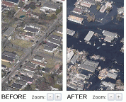 Virtual Earth Application on MSNBC Shows
Katrina Devastation
Virtual Earth Application on MSNBC Shows
Katrina DevastationA new MSNBC feature
shows Katrina hurricane damage using MSN Virtual Earth. Aerial photos
from helicopters depict before and after pictures of large swaths of
the affected area.
Microsoft Gives Local Search a New View
From IDG News Service - "Microsoft
Corp. has added an enhanced satellite view along with other new user
features to its local search product, which was rebranded this week
from Virtual Earth to Windows Live Local."
Windows Live Local Goes Aerial
From Microsoft Watch - "Microsoft
is making available a beta version of Windows Live Local, an online map
searching tool developed on the heels of the Virtual Earth platform."
Microsoft Offers New Window to the World
Microsoft Launches Mapping Beta
Microsoft Offers New Window to the World
From The Seattle Times -
"A few months ago, the pilot of a small Cessna flew low in the skies
over Seattle, taking pictures from 3,000 feet. The images were detailed
enough to show people on tennis courts and the colors of cars on the
street. Starting today, those images — and others collected
from a dozen or so other cities — will be available on a new
online search and mapping service from Microsoft."
Microsoft Launches Mapping Beta
From ZDNet -
"Windows Live Local offers a 45° birds-eye view and a range of
viewing angles, but currently only covers parts of the US. Microsoft on
Thursday will unveil a beta version of Windows Live Local, which is
based on its Virtual Earth aerial image application and integrates
local search, mapping, driving directions and yellow pages with a
bird's-eye view of major US cities."
Virtual Earth Competition Results
From ViaVirtualEarth -"The winner was the MapStats application. MapStats is a counter which visualizes the visitors of a website. The red squares indicate where visitors came from. The less opaque they are, the less visitors came from that location. We received many great apps that made judging hard, and among these CREMaps and Zoom To Hotels were especially notable."
Microsoft Offers Range Of Programs That Run Off Web, Not Hard Disk
From The Wall Street Journal -" This is a local search and mapping service, complete with aerial photos of cities and towns. Built on an earlier Microsoft project called Virtual Earth, it's intended to compete with the local search and mapping features of Google and Yahoo."
Magellan Ingénierie of France, a specialist in fleet-management technology, has launched a new version of its multi-vehicle scheduling and route optimization software – TourSolver 3. Using TourSolver to plan vehicle routes can save businesses up to 40% of their total logistics costs, providing an affordable and simple solution to complex problems.
Circulation Tacticians Shows Potential Newspaper Subscribers
Circulation Tactician excels because it merges a newspaper’s existing circulation data with Experían’s INSOURCE™ database of over 120 million U.S. Households and delivers it on Simmons software including Microsoft’s MapPoint.
Reduce Logisitics Costs with TourSolver 3 for MapPoint
With an array of new constraints in version 3, TourSolver manages over 60 total for handling even the most complex scheduling problems. New constraints include: enhanced management of delivery days and time slots, frequency of visits, distinct places of departure and arrival, variable mileage costs, new legal constraints, and speed weighting. In a few clicks, TourSolver calculates cost-effective routes for an entire fleet, taking all the variables into account.
MapPoint Project Guides Posted on Microsoft Partner Program Site
The projects in this category provide your business with the opportunity to deliver location-based solutions using MapPoint, the MapPoint Web Service, and the MapPoint Location Server. Projects include: "Building a Store Locator with MapPoint Web Service", "Building a Tracking and Dispatch Solution with Microsoft MapPoint Location Server", and "Fleet Analysis with Microsoft MapPoint 2004".
MapPoint B2B Launched
MapPoint B2B is a blog that focuses on MapPoint's Business to Business customers and how Microsoft mapping products can be used in different enterprise scenarios. One of its recent entries describes how to integrate MSN Virtual Earth and MapPoint Web Service.
GPS Magic Plus Gets New Features
"The ultimate software add-on for Microsoft MapPoint 2002 onwards just some of the features are: audible and visual warnings on route of junctions roundabouts & over 35,500 traffic cameras in the U.K."
GEOTAB Checkmate Version 5.0 Available for Download
CHECKMATE 5 is an off-the-shelf, fully featured software package for small through large business: All-in-one compatibility for Geotab GO Key, Radio Wireless, NEW Live cellular AVL and NEW GPS2go Mobile.
Programming MapPoint .NET Support Site Launched
"On this site, you can find resources that compliment the book's contents, such as sample code, tips & tricks and latest product information; in any case if you can't find the information you are looking for, please don't hesitate to contact me via email."
Microsoft, 7-Eleven, and JC Penney Award Scholarships
Participating students will each receive their own copy of Microsoft MapPoint 2004, an application that allows users to visualize trends and opportunities by combining maps, valuable demographics and their own business data. Simmons will also provide students with SimmonsLOCAL, a software program that allows affordable access to detailed information about local consumers including their purchasing habits, lifestyles and psychographics.
Web Site Visitor Mapping App Using Virtual Earth (beta)
Virtual Earth (VE) Mashup is webmaster tool for viewing realtime locations of web site visitors.
Trimble Navigator Sample Provides Mobile Workers with LBS
Trimble and Connected Innovation LLC have worked together to develop Trimble® Navigator Sample Application software that provides mobile workers with in-field access to the real-time maps and driving directions capabilities of the Microsoft MapPoint Web Service.
Pharos Supplies Microsoft GPS for AutoRoute 2006
Pharos Science and Applications Inc. has announced their supply agreement with Microsoft. Pharos will supply an advanced highly sensitive SiRFXTrac powered GPS receiver to be combined with the latest version of Microsoft's AutoRoute 2006 with GPS Locator.
Maximizer Software Delivers Feature-Rich Release
Maximizer Enterprise 9 includes improved Integration with Microsoft Office: instant export of data to Excel®; improved integration with Word; access to MapPoint® directly from the address book for global maps and directions.
Mobile Tech Pilot Delivers Exceptional Customer Benefits
"We anticipate that the final product will include the most highly requested features, as well as some additional functionality we are considering such as location-aware capabilities and integration with Microsoft MapPoint®."
CARTASITE Teams with Siemens to Provide Telemetry Solutions
"To take a further leadership role in the emerging market for automated remote asset management, known as machine-to-machine (M2M) telemetry technology, Siemens and CARTASITE announced the intent to form a new strategic alliance that will combine CARTASITE’s remote asset management software and monitoring capabilities with the Siemens M2M One portfolio of wireless solutions."
MileCharter v1.4 Now Available on CD-ROM
MileCharter quickly and efficiently calculates mileage tables using Microsoft MapPoint. MileCharter can be quickly set with a few clicks to batch compute hundreds if not thousands of route calculations. Both distances and times can be calculated. All output is to a Microsoft Excel spreadsheet.
HawkEye for MapPoint Now Supports Virtual Earth
"NEW! HawkEye now includes an option to use Virtual Earth for the Aerial views instead of Google Earth."
Adolys Provides New MapPoint Software (Freeware / Shareware)
GeOptim Marketing: full featured geomarketing tool. Create your own custom catchment areas (drawing, travel time or distance). Manage and analyze your data layers as you could with any Geographic Information System (GIS). Import data from Business Objects reports. Make any data or cartographic selection. Find the nearest points.
Web Mapping Services Expand
From Cape Cod Times - "Stephen Lawler, general manager of Microsoft's MapPoint unit, says users want to be able to ask a search engine not only to find places for them but also to provide a rich visual environment to explore on their own."
The Model of Mapping
From Mercury News - "...Meanwhile, MSN Virtual Earth from Microsoft was teaming with MSNBC to offer maps with before-and-after aerial images of the Gulf Coast clear enough to make out front porches and power lines. MapQuest had once offered satellite images, but scrapped them after executives deemed them fun but not that useful."
Virtual Earth Competition Results
From ViaVirtualEarth -"The winner was the MapStats application. MapStats is a counter which visualizes the visitors of a website. The red squares indicate where visitors came from. The less opaque they are, the less visitors came from that location. We received many great apps that made judging hard, and among these CREMaps and Zoom To Hotels were especially notable."
Microsoft Offers Range Of Programs That Run Off Web, Not Hard Disk
From The Wall Street Journal -" This is a local search and mapping service, complete with aerial photos of cities and towns. Built on an earlier Microsoft project called Virtual Earth, it's intended to compete with the local search and mapping features of Google and Yahoo."
MapPoint and Technology News
Magellan Ingénierie’s TourSolver Keeps Vehicles on TrackMagellan Ingénierie of France, a specialist in fleet-management technology, has launched a new version of its multi-vehicle scheduling and route optimization software – TourSolver 3. Using TourSolver to plan vehicle routes can save businesses up to 40% of their total logistics costs, providing an affordable and simple solution to complex problems.
Circulation Tacticians Shows Potential Newspaper Subscribers
Circulation Tactician excels because it merges a newspaper’s existing circulation data with Experían’s INSOURCE™ database of over 120 million U.S. Households and delivers it on Simmons software including Microsoft’s MapPoint.
Reduce Logisitics Costs with TourSolver 3 for MapPoint
With an array of new constraints in version 3, TourSolver manages over 60 total for handling even the most complex scheduling problems. New constraints include: enhanced management of delivery days and time slots, frequency of visits, distinct places of departure and arrival, variable mileage costs, new legal constraints, and speed weighting. In a few clicks, TourSolver calculates cost-effective routes for an entire fleet, taking all the variables into account.
MapPoint Project Guides Posted on Microsoft Partner Program Site
The projects in this category provide your business with the opportunity to deliver location-based solutions using MapPoint, the MapPoint Web Service, and the MapPoint Location Server. Projects include: "Building a Store Locator with MapPoint Web Service", "Building a Tracking and Dispatch Solution with Microsoft MapPoint Location Server", and "Fleet Analysis with Microsoft MapPoint 2004".
MapPoint B2B Launched
MapPoint B2B is a blog that focuses on MapPoint's Business to Business customers and how Microsoft mapping products can be used in different enterprise scenarios. One of its recent entries describes how to integrate MSN Virtual Earth and MapPoint Web Service.
GPS Magic Plus Gets New Features
"The ultimate software add-on for Microsoft MapPoint 2002 onwards just some of the features are: audible and visual warnings on route of junctions roundabouts & over 35,500 traffic cameras in the U.K."
GEOTAB Checkmate Version 5.0 Available for Download
CHECKMATE 5 is an off-the-shelf, fully featured software package for small through large business: All-in-one compatibility for Geotab GO Key, Radio Wireless, NEW Live cellular AVL and NEW GPS2go Mobile.
Programming MapPoint .NET Support Site Launched
"On this site, you can find resources that compliment the book's contents, such as sample code, tips & tricks and latest product information; in any case if you can't find the information you are looking for, please don't hesitate to contact me via email."
Microsoft, 7-Eleven, and JC Penney Award Scholarships
Participating students will each receive their own copy of Microsoft MapPoint 2004, an application that allows users to visualize trends and opportunities by combining maps, valuable demographics and their own business data. Simmons will also provide students with SimmonsLOCAL, a software program that allows affordable access to detailed information about local consumers including their purchasing habits, lifestyles and psychographics.
Web Site Visitor Mapping App Using Virtual Earth (beta)
Virtual Earth (VE) Mashup is webmaster tool for viewing realtime locations of web site visitors.
Trimble Navigator Sample Provides Mobile Workers with LBS
Trimble and Connected Innovation LLC have worked together to develop Trimble® Navigator Sample Application software that provides mobile workers with in-field access to the real-time maps and driving directions capabilities of the Microsoft MapPoint Web Service.
Pharos Supplies Microsoft GPS for AutoRoute 2006
Pharos Science and Applications Inc. has announced their supply agreement with Microsoft. Pharos will supply an advanced highly sensitive SiRFXTrac powered GPS receiver to be combined with the latest version of Microsoft's AutoRoute 2006 with GPS Locator.
Maximizer Software Delivers Feature-Rich Release
Maximizer Enterprise 9 includes improved Integration with Microsoft Office: instant export of data to Excel®; improved integration with Word; access to MapPoint® directly from the address book for global maps and directions.
Mobile Tech Pilot Delivers Exceptional Customer Benefits
"We anticipate that the final product will include the most highly requested features, as well as some additional functionality we are considering such as location-aware capabilities and integration with Microsoft MapPoint®."
CARTASITE Teams with Siemens to Provide Telemetry Solutions
"To take a further leadership role in the emerging market for automated remote asset management, known as machine-to-machine (M2M) telemetry technology, Siemens and CARTASITE announced the intent to form a new strategic alliance that will combine CARTASITE’s remote asset management software and monitoring capabilities with the Siemens M2M One portfolio of wireless solutions."
MileCharter v1.4 Now Available on CD-ROM
MileCharter quickly and efficiently calculates mileage tables using Microsoft MapPoint. MileCharter can be quickly set with a few clicks to batch compute hundreds if not thousands of route calculations. Both distances and times can be calculated. All output is to a Microsoft Excel spreadsheet.
HawkEye for MapPoint Now Supports Virtual Earth
"NEW! HawkEye now includes an option to use Virtual Earth for the Aerial views instead of Google Earth."
Adolys Provides New MapPoint Software (Freeware / Shareware)
GeOptim Marketing: full featured geomarketing tool. Create your own custom catchment areas (drawing, travel time or distance). Manage and analyze your data layers as you could with any Geographic Information System (GIS). Import data from Business Objects reports. Make any data or cartographic selection. Find the nearest points.
Web Mapping Services Expand
From Cape Cod Times - "Stephen Lawler, general manager of Microsoft's MapPoint unit, says users want to be able to ask a search engine not only to find places for them but also to provide a rich visual environment to explore on their own."
The Model of Mapping
From Mercury News - "...Meanwhile, MSN Virtual Earth from Microsoft was teaming with MSNBC to offer maps with before-and-after aerial images of the Gulf Coast clear enough to make out front porches and power lines. MapQuest had once offered satellite images, but scrapped them after executives deemed them fun but not that useful."
