


MapPoint News
 The MapPoint Business Unit Gets a New
Name
The MapPoint Business Unit Gets a New
NameFrom MapPoint B2B - "The Microsoft MapPoint Business Unit has officially changed it's name to the Microsoft Virtual Earth Business Unit. We'll maintain the MapPoint branding for our products, but moving forward our online platform will be called Virtual Earth, as well as, our BU."
Where the Heck Are We?
From Redmondmag.com - "Microsoft's MapPoint is a solid business-savvy mapping tool, but it needs more frequent updates... Easy to customize, MapPoint offers stellar mapping and labeling tools, unparalleled zoom and an easy-to-navigate interface that simplifies finding places and working with maps. In many cases, however, the maps it generates are anywhere from three to seven years out of date."
Pushpin Tool - Wish List Wanted for Next Version
An "updated version of Pushpin Tool in the planning stages... the Pushpin Tool has not been upgraded in a few years but there are a few new items I plan on adding and a few minor fixes to be made. I would like to hear from you what you think could be included in Pushpin Tool to make it better or fix something that’s already in it."
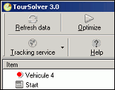 TourSolver added to Mapping-Tools.com
Product Line-up
TourSolver added to Mapping-Tools.com
Product Line-up"TourSolver is a powerful route planning and optimization tool. TourSolver is capable of optimizing hundreds of customers amongst multiple routes. A wide variety of constraints can be applied, including times, vehicle capacities, and legal restrictions."
Casino City Press Releases Global Gaming Almanac
"The CD also includes the entire contents of the print edition in PDF format along with 200 annual reports of international gaming property owners and a MapPoint file displaying world gaming properties geographically on a map."
New Expert Page added to GPS Magic
"This page allows you to start GPS Magic Automatically when MapPoint Starts. And you can now also cause GPS Magic to skip chosen none essential Instructions."
Mattys Consulting Large Format Map of Manhattan
Mattys Consulting prepared this 36 x 42 pdf map of Manhattan using MapPoint.
AirMagnet First to Integrate Spectrum Analysis
"AirMagnet Survey 3.0 integrates Microsoft MapPoint® and the ability to map to GPS coordinates, which gives companies a literal blueprint to build reliable outdoor wireless networks. This capability is essential for accurate surveys of mesh networks and other outdoor Wi-Fi implementations, built in growing numbers by cities and municipalities across the U.S. to provide public Wi-Fi access to residents and businesses."
 Now
Taking Orders for MapPoint 2006
Now
Taking Orders for MapPoint 2006"MP2Kmag is now accepting pre-orders for MapPoint 2006 in tandem with our new Routing and Programming Tools spreadsheet. This suite of tools will be included for free with all orders. For more information and to order go to our secure MapPoint 2006 ordering form."
Central and Eastern Europe are Back!
A post earlier this month on Chris Pendleton's web site suggested MapPoint 2006 EU will include "A TON OF MORE DATA FOR EUROPE". Hopefully that is a good sign that Central and Eastern Europe will be making it back into the CD product (they were in the 2002 version but not 2004).
Mapping-Tools.com releases pre-computed US mileage charts
"When you purchase our charts, you will receive 51 individual data files:
- Individual tables for each of the 50 States in the Union.
- A large pan-USA table with the 250 largest cities included. (includes DC but excludes HI and PR)."
advertisement
|

Virtual Earth and Windows Live Local News
 Boulder-based Vexcel Acquired by
Microsoft
Boulder-based Vexcel Acquired by
MicrosoftVexcel specializes in remote sending and data acquisition and processing. This may seem like a step away from Microsoft's core competency which is selling software. Vexcel is more of a hardware, services, and data (imagery) company. However, the acquisition should help Microsoft compete in providing the freshest and most detailed imagery for Windows Live Local and Virtual Earth.
MapPoint Web Service 4.1 Released
From Telematics Update - "Microsoft has announced the launch of Microsoft® MapPoint® Web Service 4.1 with expanded map coverage, worldwide city-to-city routing and improved frequency of ZIP code updates."
Virtual Earth Madness Starts - Grand Prize XBOX 360
The contest runs from February 28 – April 1(Midnight). You must register at ViaVirtualEarth. All questions and discussion for the contest is through the Virtual Earth Madness Forum.
 Maps.MSN.Com Gets A New Destination
Microsoft has switched over the public site for Microsoft's main map delivery url address to Windows Live Local. The anticipated move is the culmination of more than a year's worth of high profile and high priority work within MS to keep up with rival technologies.
Partner Readiness Briefing for Virtual Earth
"This briefing will include an overview of the functionality of the Virtual Earth Commercial Control, a pricing and licensing review, and will explore the kinds of new opportunities Virtual Earth provides for partners."
New Bird's Eye Imagery
From MapPoint B2B -
"We
just loaded some new Bird's Eye imagery into the Virtual Earth
platform, and thus into the Windows Live Local application. We now have
imagery for the following counties:· Benton, AR·
Broomfield, CO
·
Orange, FL · Catoosa, GA · Marion, KS
· Lafourche, LA · Lincoln, LA
· Dakota, MN · Olmstead, MN
· Mercer, NJ · Montgomery, PA
· Rutherford,
TN · Tarrant, TX."Virtual Earth Workshop at Location Intelligence Conference
"In this session you'll learn how to use the VE platform to add maps, geocoding, state-of-the-art imagery, and other location functionality into your business applications."
 Microsoft Selects Group 1's Geocoding
Software
Microsoft Selects Group 1's Geocoding
Software"GeoStan provides a more comprehensive set of parcel and address-level geocodes by combining USPS® and CPC postal data with spatial data files from the world's leading data providers. Precisely defining the location of an address with latitude and longitude coordinates, the location is then displayed on the MapPoint Web Service map or Windows Live Local photo."
Preview Street-side Photos for Live.com
From MSN Search's Weblog - "The Virtual Earth team is pleased to launch a preview of a new feature we have been working on – interactive Street-side browsing. You can try it out at http://preview.local.live.com Street-side imagery allows you to drive around a city looking at the world around you as if you were in a car."
New Site Highlights Windows Live Local Bird's Eye Imagery
From MapPoint B2B - "Check
out this site: http://www.birdseyetourist.com.
It's a great reference for finding unique eye candy available in
Windows Live Local. Plus, I found some imagery where I didn't know we
actually had imagery!"
 Two Part Article on Working With Version
2 of the VE Control
Two Part Article on Working With Version
2 of the VE ControlViaVirtualEarth
has
published a new articles entitled "Creating Your First Virtual Earth v2
Page" in two parts. The first part helps "you understand how to get
started using version 2 of the Virtual Earth Map Control. The map
control used in Virtual Earth is a JScript control and a cascading
style sheet. Together these can be used to present a great user
experience for online map content."
EarthData Delivers Products To Windows Live Local
"Under
the 5-year agreement, EarthData will supply Microsoft with new imagery,
lidar, and radar data acquisition and map production support to keep
Windows Live Local populated with current, accurate, high-resolution
geospatial information. Microsoft will also have access to EarthData's
own data archives."
GeoWeb 2006 Conference Welcomes Microsoft as a New Sponsor
"We are pleased to sponsor GeoWeb 2006 and to help bring location standards to the forefront of the search and mapping industry,” said Stephen Lawler, general manager of the Virtual Earth Business Unit at Microsoft. “Microsoft continues to make significant investments in location-based services and local search, and is excited to share this vision with our industry partners and customers.”
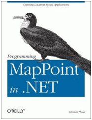
Programming MapPoint in .NET - Sample code is now online
From Chandu Thota's Weblog - As you know, my new book Programming MapPoint in .NET comes with C# samples that can be downloaded form O'Reilly site. Now you can also see the samples online at book's support site. This source code comes with updated sample for Virtual Earth (Chapter 11 - Programming with Virtual Earth).
ViaVirtualEarth Superbowl Mashup
Check out this year's Super Bowl stadium and surrounding attractions on WLL. Also browse your way around previous years stadiums and results.
Vote for features in the next release of Virtual Earth
From the Windows Live Local / Virtual Earth Blog - "Work is well underway for the third major release of Virtual Earth/Windows Live Local. We want to hear what you want added to the site. When we did a similar poll back in October the feedback you provided was hugely valuable in shaping release 2."
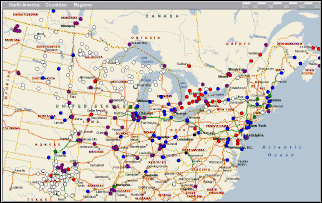
Masternaut Keeps Track of D Morgan's Tippers
From Transport News Network - "Masternaut uniquely identifies each vehicle and calculates its position by GPS, transmits this information via GPRS to a central server that can then be accessed in real time by any web enabled PC. The record of the vehicles position is displayed using Microsoft MapPoint® online street mapping in order to place the information into a real world context."
Mini-Tutorial on Ajax and Virtual Earth in Three Parts
From the Windows Live Local / Virtual Earth Blog - "In part 2 of this tutorial we got the AJAX stuff working, but all the app did was echo back it's input - not terribly exciting. Today we’ll add some simple code to the server component to make a call to the MapPoint Web Service (MWS) to reverse-geocode the coordinate passed in."
 O'Reilly Where 2.0 Conference: The
Future of Mapping and Local Search
O'Reilly Where 2.0 Conference: The
Future of Mapping and Local Search
"O'Reilly Media is planning the second Where 2.0 Conference, happening June 13-14 at the Fairmont Hotel in San Jose, California. Presentations will be made by the likes of Mike Liebhold (Institute for the Future), Perry Evans (LocalMatters), Felix Peterson (Plazes), Stewart Butterfield (Yahoo! Inc.), Steve Lombardi (Microsoft), Di-Ann Eisnor (Platial), and Schuyler Erle (MetaCarta), among many others."
Industry Experts to Keynote at GeoWeb 2006
"Michael Jones, CTO of Google Earth; Stephen Lawler, general manager of Microsoft’s Virtual Earth; and Kurt Cagle, author and technology architect for Mercurial Communications, will be featured keynote speakers. Conference organizer, Galdos Systems Inc., and conference supporter, the Geospatial Information & Technology Association (GITA), expect to add at least one other keynote speaker as the conference gets closer."
Google Maps vs. the Rest
"Appearing late in the game, Microsoft's Virtual Earth, still in Beta, has some interesting features that may compete with Google Earth and World Wind. Utilizing NAVTEQ technology and USGS images, users can view road maps, aerial maps, and a bird's eye view of available locations."
Next Five Years of European LBS Market
"Highlights from the report: Overview of LBS offerings, market strategies and equipment in 27 European markets. Case studies of the LBS strategies of 10 leading mobile operators. Complete update on location-based regulatory and standards in Europe..."
Microsoft Product Delays Stir Unrest
From EETimes.com - "Microsoft employees writing to an anonymous blog are calling for the heads of high-level company executives -- including Steve Ballmer and Jim Allchin -- after the double delay debacle this week when the Redmond, Wash. developer shoved its two most profitable products into 2007."
 Location Intelligence Conference 2006 -
"Profiting from Location Intelligence"
Location Intelligence Conference 2006 -
"Profiting from Location Intelligence"
"Since we first launched this conference two years ago, we are seeing an explosion in the interest for location technology. The 2006 conference will look to accelerate the understanding about how to profit from location technology to turn the plethora of business data into location intelligence."
Windows Live ID Replacing Passport
"Sources familiar with the situation say Windows Live ID is part of up to three-dozen Live services currently in development."
GeoWeb Call for Papers Issued
"GeoWeb 2006 is a landmark event about unleashing the economic potential associated with the convergence of XML, Web services and geographic information systems. Hosted by Galdos Systems Inc. in conjunction with the Geospatial Information & Technology Association (GITA), GeoWeb 2006 welcomes both public and private organizations to meet, discuss and learn about today’s most innovative geospatial technologies. The conference will include dedicated workshops on Geography Markup Language (GML), KML, MapPoint, LandXML and OGC Web Services for GIS."
GeoWeb 2006 Conference Welcomes Microsoft as a New Sponsor
"We are pleased to sponsor GeoWeb 2006 and to help bring location standards to the forefront of the search and mapping industry,” said Stephen Lawler, general manager of the Virtual Earth Business Unit at Microsoft. “Microsoft continues to make significant investments in location-based services and local search, and is excited to share this vision with our industry partners and customers.”
Programming MapPoint in .NET - Sample code is now online
From Chandu Thota's Weblog - As you know, my new book Programming MapPoint in .NET comes with C# samples that can be downloaded form O'Reilly site. Now you can also see the samples online at book's support site. This source code comes with updated sample for Virtual Earth (Chapter 11 - Programming with Virtual Earth).
ViaVirtualEarth Superbowl Mashup
Check out this year's Super Bowl stadium and surrounding attractions on WLL. Also browse your way around previous years stadiums and results.
Vote for features in the next release of Virtual Earth
From the Windows Live Local / Virtual Earth Blog - "Work is well underway for the third major release of Virtual Earth/Windows Live Local. We want to hear what you want added to the site. When we did a similar poll back in October the feedback you provided was hugely valuable in shaping release 2."
Masternaut Keeps Track of D Morgan's Tippers
From Transport News Network - "Masternaut uniquely identifies each vehicle and calculates its position by GPS, transmits this information via GPRS to a central server that can then be accessed in real time by any web enabled PC. The record of the vehicles position is displayed using Microsoft MapPoint® online street mapping in order to place the information into a real world context."
Mini-Tutorial on Ajax and Virtual Earth in Three Parts
From the Windows Live Local / Virtual Earth Blog - "In part 2 of this tutorial we got the AJAX stuff working, but all the app did was echo back it's input - not terribly exciting. Today we’ll add some simple code to the server component to make a call to the MapPoint Web Service (MWS) to reverse-geocode the coordinate passed in."
Other Mapping and Technology News
O'Reilly Where 2.0 Conference: The
Future of Mapping and Local Search"O'Reilly Media is planning the second Where 2.0 Conference, happening June 13-14 at the Fairmont Hotel in San Jose, California. Presentations will be made by the likes of Mike Liebhold (Institute for the Future), Perry Evans (LocalMatters), Felix Peterson (Plazes), Stewart Butterfield (Yahoo! Inc.), Steve Lombardi (Microsoft), Di-Ann Eisnor (Platial), and Schuyler Erle (MetaCarta), among many others."
Industry Experts to Keynote at GeoWeb 2006
"Michael Jones, CTO of Google Earth; Stephen Lawler, general manager of Microsoft’s Virtual Earth; and Kurt Cagle, author and technology architect for Mercurial Communications, will be featured keynote speakers. Conference organizer, Galdos Systems Inc., and conference supporter, the Geospatial Information & Technology Association (GITA), expect to add at least one other keynote speaker as the conference gets closer."
Google Maps vs. the Rest
"Appearing late in the game, Microsoft's Virtual Earth, still in Beta, has some interesting features that may compete with Google Earth and World Wind. Utilizing NAVTEQ technology and USGS images, users can view road maps, aerial maps, and a bird's eye view of available locations."
Next Five Years of European LBS Market
"Highlights from the report: Overview of LBS offerings, market strategies and equipment in 27 European markets. Case studies of the LBS strategies of 10 leading mobile operators. Complete update on location-based regulatory and standards in Europe..."
Microsoft Product Delays Stir Unrest
From EETimes.com - "Microsoft employees writing to an anonymous blog are calling for the heads of high-level company executives -- including Steve Ballmer and Jim Allchin -- after the double delay debacle this week when the Redmond, Wash. developer shoved its two most profitable products into 2007."
Location Intelligence Conference 2006 -
"Profiting from Location Intelligence""Since we first launched this conference two years ago, we are seeing an explosion in the interest for location technology. The 2006 conference will look to accelerate the understanding about how to profit from location technology to turn the plethora of business data into location intelligence."
Windows Live ID Replacing Passport
"Sources familiar with the situation say Windows Live ID is part of up to three-dozen Live services currently in development."
GeoWeb Call for Papers Issued
"GeoWeb 2006 is a landmark event about unleashing the economic potential associated with the convergence of XML, Web services and geographic information systems. Hosted by Galdos Systems Inc. in conjunction with the Geospatial Information & Technology Association (GITA), GeoWeb 2006 welcomes both public and private organizations to meet, discuss and learn about today’s most innovative geospatial technologies. The conference will include dedicated workshops on Geography Markup Language (GML), KML, MapPoint, LandXML and OGC Web Services for GIS."