Welcome
to a special edition of the MP2Kmag
Update focusing on MapPoint 2006. The North American version was
released several weeks ago and the European version is slated to come
out in just a few weeks. Both versions of MapPoint 2006 include all new
street and demographics data, a new map style for night-time driving,
and a number of cool GPS features for navigation and driving. Check the
features
section for more details.
The North American version of MapPoint 2006 is widely available from retailers and some Microsoft MapPoint Partners. You can also purchase directly from our store
or pre-order the European version using our secure order form.
Sometime later in August or September we are planning to publish
another e-book "MP2Kmag's Guide to What's New in MapPoint 2006"
covering both the North American and European versions. If you did not
previously read it, take a look at the What's New Guide we published in
2003 for MapPoint 2004 - MapPoint-2004-Guide.zip.
The new publication will be along these lines but we plan to go more in
depth. For a limited time you can pre-order
the guide for $8, after publication the price will go up to
$15.
MP2K Magazine is your source for independent news and information about
MapPoint technologies and products and is home to the popular web forum
for MapPoint users and developers. In this issue we
feature new
articles from Mohanraj Annamalai and Richard
Marsden. We also publish a map submitted by Coverpoint MapPoint
training from their e-book series of 101 MapPoint usage scenarios for
business.
This Issue's Contents at a Glance
- features:
New Features in MapPoint 2006, Coverpoint MapPoint Usage Scenarios,
Write for MP2K Magazine
- articles:
Implementing Location-Based Functionalities with the MapPoint Web
Service, Using MapPoint with Python Part II
- news:
MapPoint 2006 News Roundup, In the news: PinsToFile2006, Adolys,
GridImp, SecuraCom,
MapCruncher, WLL Outlook Plugin, MapLinXWeb GIS,
Maps4MyApps, Zillow, and more
- forum: Forum
Highlights, Over 13,700 posts
and more than 3,750 Registered Users, New Forum Address Coming -
Bookmark http://www.mapforums.com!
Happy Mapping and please forward this newsletter to anyone who would be
interested!
|
|
advertisement
The new standard for route
optimization
Don’t miss the sign
to get your fleet operations on the right track.
With TourSolver for
MapPoint
you can easily plan & optimize your delivery routes, sales
& service calls for your entire workforce. TourSolver
calculates stop sequence for your fleet while taking over 60
constraints into account.
Start reducing unnecessary
mileage, & fuel usage today.
|
|
|
|
Features
 New Features in MapPoint 2006 New Features in MapPoint 2006
• Completely Refreshed Data
Use updated geographic and demographic data sets in MapPoint to display
trends and illustrate key points on maps.
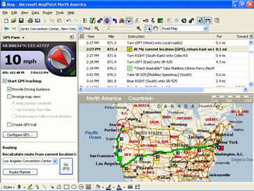
• New Advanced GPS Features
The new GPS task pane uses information from your connected, compatible
GPS device to display your current location, speed and traveling
direction.
• Voice and Text Directions for Windows XP Users
New Driving Guidance finds your location from a connected GPS device
and combines it with a route you have created to give you
voice-prompted driving directions.
• Microsoft Location Finder
New Location Finder uses your computer’s wireless network
capability and a database of known Wi-Fi access points to display your
location on maps, even if you do not have a GPS device.
• New Map Style for Low-light Conditions
New Map style for low-light conditions makes it easier to view maps on
your laptop computer.
• Pocket Streets
Microsoft Pocket Streets makes it easy for you to create custom maps in
MapPoint and then export themfor use on your Microsoft Windows
Mobile®–based Smartphone or Pocket PC.
See
our special MapPoint 2006 News coverage below for more information on
this long awaited upgrade from MapPoint 2004.
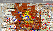
101 MapPoint
Usage Examples from Coverpoint
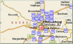 This
is map usage scenario #18 from the e-book "101 Studies in Data
Visualization Using Maps - Book 1" recently released by Coverpoint.
SCENARIO:
Business is doing well and the time has come to open another
restaurant.
QUESTION:
Where is the best place to open the next one. It must not be too far
from the original in case some staff have to travel to the new one in
the early days.
METHOD:
Plot customers according to their postcodes and the location of the
main restaurant to identify where our present customers are coming
from.
OUTCOME:
As would be expected the majority of customers come from the Chelmsford
area. Although customers are traveling from a good geographic spread it
can be seen that Brentwood supplies quite a few as well as Billericay.
Brentwood is chosen to be the location for the next restaurant
"Sanctuary 2" This location choice has enough proximity to Basildon and
also the East london area to give it every chance of success.
Click here to
view the full screenshot and for instructions to download the first
volume of this new e-book.
 Get
Published in MP2K
Magazine Get
Published in MP2K
Magazine
If you have a MapPoint presentation, neat programming technique, or
would simply like to share the ways in which you are using MapPoint
technology or any other ideas, contact us to discuss how we can turn
your knowledge into
an article and share your experience with the rest of the MapPoint
community of users and developers.
Writers often plug their consulting service or other business interest
through their bio which appears at the bottom of the article. Others do
it for the Large MapPoint Mug (see right!). Whatever the
reason, it is
rewarding to share and take credit for the knowledge you share with the
rest of the community.
Thanks to Marvin
Hlavac for allowing us to use the
picture on the right of his Maltese puppy eating from the MapPoint
mug.
|
|
advertisement
MapPoint
2006
Order
MapPoint 2006 Now and Get Free Priority Shipping
MP2Kmag
is pleased to offer MapPoint 2006 NA along with our Routing and
Programming Tools Spreadsheet ($95 value) for just $259.
There
are again two versions, North America and Europe and the maps are
updated with the most recent digital map databases. Other new features
include:
- integration with Windows Live Local and the Locate Me
feature
-
a new Night-time map style and other driver guidance
features
- Navteq streets and a TON more data for the European version
Update your MapPoint maps to the latest digital map databases!
Order
Your Licenses Today - Free Priority Shipping!
|
|
|
|
|
Articles
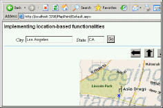 Implementing Location-Based
Functionalities with the MapPoint Web Service Implementing Location-Based
Functionalities with the MapPoint Web Service
This article
by Mohanraj Annamalai illustrates how to find the center point from a
set of Latitudes and Longitudes. The article also discusses how to
programmatically generate a map using the Microsoft MapPoint Web
Service and implement interactive features like: re-centering a map
based on the clicked location, panning north, south, east, and west.
"When implementing location-based functionalities (e.g. rendering maps)
for business applications, finding the center of the data set is an
important step. The mode “the number with the highest
frequency” - does a nice job in telling where the center of
the data set is. This article illustrates how to find the center point
from a set of Latitudes and Longitudes. The article also discusses how
to programmatically generate maps using the Microsoft MapPoint Web
Service and implement interactive features like: re-centering a map
based on the clicked location, panning north, south, east, and west."
 Full
article text Full
article text  Discuss
this story Discuss
this story
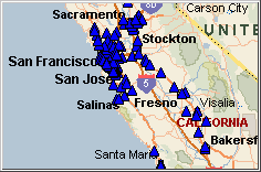 Using Python to Control MapPoint, Part 2 Using Python to Control MapPoint, Part 2
Second of a two-part article by Richard Marsden on scripting MapPoint
using Python. In this part Richard shows how to use Python to plot the
“250 largest cities in California”.
"In Part 1, I showed how Python could be used to control MapPoint.
Python is a scripting language that is ideally suited to text
processing. Hence it can be used as a replacement for
MapPoint’s Data Import Wizard in situations that require some
processing intelligence. As an example, we will use it to plot the
“250 largest cities in California”.
Our source data is the US Census Bureau’s 2000 Gazetteer of
Places. This file (places2k.txt) and format specification can be found
here:
http://www.census.gov/geo/www/gazetteer/places2k.html
The data file is a text file, with one line per place. A place is
typically a town or city, although it may also be a CDP (Census
Designated Place) – ie. an unincorporated town. Each line
follows a fixed column format, and includes information such as
location (longitude, latitude), area, and population."
Submit
an article
for publication and
receive a Large
MapPoint Mug!
|
|
advertisement
The
Virtual Earth platform represents an integrated set of services that
combines unique bird's-eye, aerial, and satellite imagery with
best-of-breed mapping, location and search functionality. It enables
companies to deliver innovative solutions and breakthrough customer
experiences. The Virtual Earth platform powers a variety of consumer,
enterprise and government applications.
Take
your websites and applications to the next level by creating an
immersive online mapping and search experience. Consumers can easily
search, discover and visualize company location data and relevant local
information. If your app is stuck with flat, boring maps, click here
and we'll help you migrate.
Locate. Integrate. Innovate. Are you ready?
|
|
|
MapPoint 2006 News and Articles
 MapPoint 2006 North America is Released MapPoint 2006 North America is Released
"Microsoft
announced the availability of MapPoint 2006, an industry leader in
business mapping software. MapPoint 2006 can help customers improve
decision-making capabilities and increase new business opportunities
through the use of maps and geographical information, enabling better
analysis, visualization and communication of business information."
Microsoft
MapPoint 2006 - Powerful Mapping Software for Business or Individual Use
From
Geography.About.com - "Overall,
MapPoint 2006 is a great piece of geographic software for personal or
business use - if you need to use spatial data to determine potential
new business sites, determine information about your customer base, or
even just want to make great presentations with maps, MapPoint 2006
will do the trick."
Microsoft
Announces MapPoint 2006
From Tech
Shout! - "According
to Microsoft, businesses continue to develop decision-making by
visualising business data with geographic elements on maps. Also
developers and independent software vendors (ISVs) continue to benefit
from MapPoint 2006’s low-cost, high-quality maps; familiar
development platform; and easy integration with Microsoft Office
solutions."
First
Look: MapPoint 2006
From
AllPointsBlog - "I
had hoped to see more spatial querying and analysis functionality to
slice spreadsheet-based information better. However, I liked the fact
that for mobile professionals that if I were to use this as a vehicle
navigation system that I don't have to rent a Hertz NeverLost system
everytime I go into a strange city."
 Microsoft
MapPoint 2006 (North America) Targets Business Geographics
From GISUser
- Microsoft
MapPoint 2006 (North America) Targets Business Geographics
From GISUser
- "What
can you do with it? Map business data. Create and view sales
territories, analyze trends, and evaluate performance by geography.
Identify new business opportunities. Combine business data with
demographics to target potential customers and focus decisions. Analyze
business data."
Turn
Your Laptop into a GPS
From
InternetNews.com - "Along
with the complete GPS system, that includes voice commands to guide the
driver to their destination, anyone can find their exact position
through the Wi-Fi positioning feature in Microsoft Location Finder. It
accesses a database of known Wi-Fi access points to determine a
user’s location."
MapPoint
2006 Launch by Microsoft
From
Microsoft Future - "MapPoint
2006’s demographic data refreshing capabilities will enable
businesses to visualize up-to-date trends and combine business data
with demographics to focus their marketing and better analyze results."
Microsoft
Releases MapPoint 2006
From SDA
Asia - "The
MapPoint desktop application has led the way in providing low-cost,
versatile mapping solutions for customers in the office and on the go,"
said Thomas Bailey, director of marketing and engineering for the
Virtual Earth business unit at Microsoft."
Microsoft
Releases MapPoint 2006
From
CXOToday.com - "Thomas
Bailey, Director - marketing and engineering for the Virtual Earth
business unit at Microsoft said, "The MapPoint desktop application has
led the way in providing low-cost, versatile mapping solutions for
customers in the office and on the go. We're proud to release MapPoint
2006, and believe this updated offline offering is a testament to the
flexibility and value of mapping technology as it extends into both
business and consumer environments."
Microsoft
Releases Mappoint 2006 For Businesses And Mobile Workers
From TMCnet
- "Field
workers, salespeople and frequent business travelers strive to maximize
their time out of the office by streamlining their scheduling and by
accessing maps, driving directions and point-of-interest information
even when offline."
Product
Review - MapPoint 2006
From
Directions Magazine - "MapPoint
2006 is the next version of Microsoft's desktop mapping software. It is
really two separate products: a desktop mapping system and an
in-vehicle navigation system. Depending on how you use it, you may see
the improvements made from the previous version, MapPoint 2004, as
valuable or not."
 PinsToFile2006
Released
From
GillesKohl.de - PinsToFile2006
Released
From
GillesKohl.de - "PinsToFile
is an Add-In for Microsoft MapPoint 2006 that can export pushpins sets
to file in the following formats: CSV (comma-separated values), e.g.
for processing in Microsoft Excel - Virtual Earth web page - GPS
exchange format for use with GPS software like Garmin MapSource... "
Data2Map
is back!
"Data2Map
provides: - Full
project and layer management. - Robust importing of shape and
pushpin
data. - Datasheet rendering of mapped layers. - Route persistence and
management. - Territory persistence and management. - Better European
support."
 All
Adolys MapPoint Products Are Now Free All
Adolys MapPoint Products Are Now Free
"GeOptim
Marketing : full featured geomarketing tool. Create your own custom
catchment areas (drawing, travel time or distance). Manage and analyse
your data layers as you could with any Geographic Information System.
Import data from Business Objects reports. Make any data or
cartographic selection. Find the nearest points..."
Downside
to MapPoint 2006
From
MapPoint B2B - "Ok, so
I've been saying all along that MapPoint 2006 is backwards compatible,
blah, blah, blah, but it's not. I just learned that the demographic
information for Canada is gone. You can still import your own
demographic data into the product..."
GridImp
v2.2 Released - Adds Support for MapPoint 2006
"GridImp
is designed to plot
gridded data in MapPoint - a type of data that cannot normally be
plotted in MapPoint. Gridded data can be indexed in various coordinate
systems and text file formats. Version 2.2 adds support for the 2006
version of Microsoft MapPoint, and is free for all existing users of
GridImp."
Internet-Based
GPS Fleet Tracking Solution In Hawaii
"Trucking
owner/operator, Mathew Jantco, states, "After reviewing and testing
several GPS products we chose the SecuraCom GPS solution, based on
consistent operation and impressive additional features. Monitoring
speed, mileage, excessive idle times, perimeter violations, nearest
vehicle to a pickup location, and maintenance alerts sold us on this
system. I can access my fleet even from my home or anywhere I travel
worldwide."
advertisement

|
Working
with pushpins in
MapPoint? Get the MapPoint 2004 Pushpin Tool for just $75. The
latest features include the ability to export lat/lon coordinates of
pushpins to Excel and advanced find Pushpin functionality. Read more
and purchase the tool here
or go
directly to paypal.
Affordable
volume
licensing
now available for
organizations wishing to distribute the Pushpin Tool to 5, 10, 20, or
50
or more users.
|
|
Virtual
Earth and Windows Live Local News
 Windows Live Local Enhancements Windows Live Local Enhancements
"Microsoft released
a
number of new things related to Virtual Earth and Windows Live Local
including V3 of the Virtual Earth control, a new free Outlook Add-in
the provides seamless integration with Windows Live Local, and a number
of new features on Windows Live Local itself such as the ability to
store and share landmarks."
New Version of Windows Live Local
"New features --
Real-time traffic flow... -- Collections. Social networking
functionality allows customers to create lists of favorite landmarks
and locations, attach personal photos and save them to a Scratchpad. --
Integration with Windows Live Messenger."
MSR MapCruncher for Virtual Earth
Download from Microsoft Research
"MapCruncher
brings mashups to
a whole new level by allowing developers to import entire maps to
supplement the existing road and aerial imagery with detailed,
application-specific information. The possibilities are endless:
bicycle maps, transit maps, national park maps, university maps,
antique city maps, or whatever drawn-to-scale maps you personally find
interesting."
 Customer Service Release 2.1 for
MapPoint Web Service
From
MapPoint B2B - Customer Service Release 2.1 for
MapPoint Web Service
From
MapPoint B2B - "Highlights
of this release include enhanced geocoding in the U.S. - we finally
ditched our home grown geocoder in exchange for a licensed one. New
API’s in the Customer Data Service to enhance data management
-
specifically, you can now geocode your batch records without having
them load into a data source."
Windows Live Local Plugin for Outlook
Download
"Map your
appointment and meeting locations directly from within
Microsoft®
Office Outlook®. Get driving directions, print detailed maps,
find
optimized trip routes, and estimate travel times. Receive reminders
based on the estimated travel time."
 Bird's Eye Imagery for the UK Bird's Eye Imagery for the UK
Steve Lombardi put
together this collection of points showing where oblique or Bird's Eye
imagery is available for the UK.
Linxoft Solutions Inc. Launches
MapLinXWeb GIS for MSCRM 3.0
"MapLinXWeb
allows CRM users to create routes between CRM elements (e.g. contacts),
find the nearest location to CRM elements and instigate marketing
campaigns directly from the map interface. “Fusing the power
of
spatial analysis to a business’ CRM data brings a whole new
level
of analysis to your business data that goes unseen through regular
tabular views” said Saeed Mousavi, CEO of Linxoft Solutions
Inc."
Real-time GPS Tracking (Beta) From Fresh
Logic Studios
"Fresh Logic
Studios has made available the ability to track GPS devices in
real-time using its Atlas mapping mashup. The beta, for software
developers, allows you to supply a GPS device position using our web
service API, and we'll keep track of its whereabouts and show you its
location in real-time."
Maps4MyApps.com - Small Blocks of MWS
Transactions Available
"Web
developers can [now] purchase Microsoft MapPoint Web Service usage
transactions in small blocks for their applications. Maps4MyApps.com
provides access to the MapPoint web platform for transactions usage
starting out as low as 1,500 transactions per month - ideal for small
or start up applications requiring map look up and driving directions."
Zillow Zooms With Microsoft
From Designtechnica - "Hot
Internet property Zillow.com has struck a deal with Microsoft to add a
new feature to its real estate research site: low-altitude, bird's-eye
views of residential areas."
Microsoft and NGA Announce Strategic
Alliance
"Microsoft
and the National Geospatial-Intelligence Agency (NGA) announced the
signing of a Letter of Understanding to advance the design and delivery
of geospatial information applications to customers. The NGA will use
the Microsoft Virtual Earth platform to provide geospatial support for
humanitarian, peacekeeping and national-security efforts."
Other Mapping and Technology News
"While
Microsoft started its
location-related product line in 1995, It is only in the last 2 years
has it begun to make a significant impact in the location space. Its
stated mission: Empower people/businesses to be more efficient and make
better decision through the power of location software."
Map Quest
From Fast Company - "Maps
enable immersive search," says Stephen Lawler, general manager of
Microsoft's MapPoint division. "You can actually see the real world as
you understand it." Microsoft recently debuted map technology called
Virtual Earth, featuring bird's-eye, 3-D photography.
New Trends In Online Traffic
"While growth
is slowing at most top Internet sites, it is skyrocketing at sites
focused on social networking, blogging and local information."
Tools
for Location-Based Development
"The
next most
commonly used location-based tool sets fell under the generic Open
Source Software category, with just less than 10% of developers using
them as a first choice. In a virtual tie, Yahoo, Microsoft MapPoint,
and Nokia were the third most cited providers of tool sets."
Web
Services and Real-Time Session Initiation Protocol
"Ubiquity
Software
and Microsoft announced they have signed an agreement to jointly
develop, market and sell converged communications solutions to
telecommunications service providers worldwide. Through the alliance,
the companies will deliver solutions that bring together Microsoft(R)
Connected Services Framework and Ubiquity's SIP Application Server (SIP
A/S), "
 Microsoft
Announces Plans for July 2008 Transition for Gates Microsoft
Announces Plans for July 2008 Transition for Gates
"The
company
announced that Chief Technical Officer Ray Ozzie will immediately
assume the title of chief software architect and begin working side by
side with Gates on all technical architecture and product oversight
responsibilities, to ensure a smooth transition. Similarly, Chief
Technical Officer Craig Mundie will immediately take the new title of
chief research and strategy officer..."
GPS-Based
Precision Time Signals
"GPS
technology
has made significant contributions to the global economy in the last
decade. Hundreds of uses of GPS now exist from stand-alone
applications, such as surveying and navigation, to more integrated,
embedded applications in which GPS is just one component."
Mapping
Portal Competition Benefits Satellite Imagery Businesses
"Dulles,
Va.-based
GeoEye also provides imagery to Redmond, Wash.-based Microsoft for
Microsoft's Virtual Earth and Windows Local programs. The Microsoft
deal dates back to June 2005 - before Orbimage Inc. merged with Space
Imaging to form GeoEye—and gives Microsoft exclusive access
to
the OrbView satellites that were owned by Orbimage."
The
Race to Dazzle: Map Sites Pile on Features
From the Wall Street Journal - "Microsoft
debuted a new series of online maps in late February that display
results from the perspective of someone walking or driving down a
street. The service, currently live for parts of Seattle and San
Francisco, is in preview and will be available for around a dozen
cities through local.live.com in the next few months."
|
advertisement
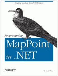
Programming MapPoint in .NET
|
Chandu
Thota's New Book from O'Reilly Press
Free USPS Priority Shipping - $48
The
first and only book in print on programming MapPoint technologies. The
book includes sections on MapPoint 2004, the MapPoint Web Service,
MapPoint Location Server, and Virtual Earth. The books is 354 pages
chock full of programming examples and map screenshots. For example,
the book spends 40 pages discussing in depth the various Data Map
styles in MapPoint 2004, dissects the DisplayDataMap method in detail,
and has a number of examples of importing data from various sources.
There are over 100 pages on the MapPoint Web Service including sections
on the Find, Route, and Render API's. Inquire about
international shipping and multiple copy discounts.
Take your MapPoint programming to the next level!
Order Your Copy Today - Free Shipping!
|
|
|
|
Forum
Highlights
Some
notable posts and
solutions from the forum over the past few
months are listed below. Keep up with the latest news and information
about MapPoint by bookmarking the forum and visiting regularly. There
are now over 13,000 posts and in the forum and over 2,600
registered users.
Active forum participants are encouraged to claim
your free copy of MP2Kmag's
Guide to What's New in MapPoint 2004. Also, stay tuned as
as plan another edition of the popular What's New Guide for the next
version of MapPoint.
We are excited to share that all of the forums will soon be migrated
to new forum software and a new url address http://www.mapforums.com.
Bookmark the new address and we look forward to seeing you on the new
forum!
July
Tutorial
MapPoint in VB6.0 Visual Studio
[1
reply]
Change
color of Arrow
[3
replies]
Problem
with ImportData - Access to Fast?
[2
replies]
Different
angles of a circle drown
[2
replies]
Extract
all streets names of a country...
[1
reply]
No
more construction updates for MapPoint 2002?
[3
replies]
Editing
Imported Data
[1
reply]
Map
Scale
[3
replies]
Help
with multiple routes
[1
reply]
COM
Add-in for Act! 2006 Contact Management Software
[2
replies]
Push
Pin Help
[3
replies]
Use
MapPoint to Locate Road and County Line Intersection
[2
replies]
June
Access
Datatable
[1
reply]
How
to close "Select a place" dialog programmatica
[1
reply]
MapPoint
Control from Visual C++ : Getting a postal code
[6
replies]
Runtime
Mappoint
[4
replies]
Advice
Please... Access Code works but could be improved
[2
replies]
Error
in calling "get_streetAddress"
[5
replies]
Deleting
pushpins in bulk
[1
reply]
Spam
or working programme
[6
replies]
PushPin
and Line Order
[2
replies]
How
to draw behind the map (C++) & disable Busy server (
[3
replies]
MP
2006 & VB6 Sample Code
[1
reply]
Microsoft's
Weak Namespace
[1
reply]
Exposing
MapPoint Enumerations
[2
replies]
Unable
to get directions from locA to locB
[3
replies]
Problems
using CalcPos
[4
replies]
More
Spatial Data Import Q's
[2
replies]
Using
PushPin\Mappoint with Garmin Street Pilot C-320
[2
replies]
Pin
Placement not allowed
[3
replies]
Availability
maps
[5
replies]
MapPoint
2004 Performance Issues (c++)
[5
replies]
How
to add AxMapPoint
[3
replies]
Trace
route
[3
replies]
There
was a problem...
[4
replies]
Grab
ALL the data from Mappoint 2004 datasets
[6
replies]
Need
help upgrading from 2004 to 2006....things arent workin
[2
replies]
Ambiguous
messages ( programming or not programming? )
[1
reply]
Integrating
MapPoint control into a VC++ application
[5
replies]
Parser
Error Message: Could not load type 'StoreLocatorVB.Gl
[1
reply]
Exporting
Data for Matched Records
[6
replies]
Route
Optimizing Software Question
[1
reply]
Newbie:
Need help with plotting Canadian locations
[1
reply]
Cancel
MapPoint Quit
[3
replies]
Forum
Spam
[1
reply]
Exporting
to Excel
[1
reply]
Multiple
instance problem
[1
reply]
Web
Services and Real-Time Session Initiation Protocol (SIP)
[1
reply]
Column
width in tables
[7
replies]
MapPoint
2004/2006 or Virtual Earth ?
[1
reply]
Integratin
MapPoint ActiveX control into VC++ 6.0
[7
replies]
Help
on converting vba code to visaul basic 2005 express
[4
replies]
Directions
from Lat/Long
[8
replies]
LatLong
to Address ??
[4
replies]
MapPoint
2004 -> 2006
[2
replies]
Change
Background Color of Map
[3
replies]
May
Canadian
Demographics to Use with MapPoint 2006
[1
reply]
A
kind of diagram
[2
replies]
MP2004
- XYToLocation
[2
replies]
HELP!!!
Saving map and pushpins...
[2
replies]
EULA
[1
reply]
Show
Name in MapPoint 2004
[5
replies]
How
to draw a line between points
[2
replies]
Pushpin
events
[1
reply]
Mappoint
on html page ?
[3
replies]
Pickups
and deliveries
[1
reply]
Odd
and even address
[1
reply]
In
context: how to solute a geo-math equation
[5
replies]
Is
it ok to link to threads here?
[2
replies]
Merge
routes/trips into one long trip
[1
reply]
Exporting
Data by Territory NOT Shapes
[2
replies]
I
must be blind - GPS Transmission from a fleet
[1
reply]
Improving
the performance of generating pushpins Programmati
[2
replies]
Display
pushpins using Eastings and Northings
[2
replies]
Territory
[1
reply]
Modifying
the Label in MapPoint
[2
replies]
Find
a street by parallel search
[1
reply]
MapPoint
2004
[1
reply]
Locking
mappoint toolbars
[1
reply]
Spam
in the forums.
[1
reply]
Have
a problem with 2004.
[2
replies]
Displaying
shipping routes in Mappoint
[1
reply]
Street
type from coords
[2
replies]
Save
maps and Open them
[1
reply]
The
format if this bitmap is not supported.
[1
reply]
GPS
[5
replies]
2006
VBA Project References in Excel
[3
replies]
Having
trouble getting symbols to match MapPoint's symbols
[1
reply]
Problem
instantiating MP Active X control in a VB and VC++
[2
replies]
MapPoint
+ .NET Compact Framework
[1
reply]
pan
problem.
[3
replies]
PushPin
dataset is saved in .ptm?
[1
reply]
Nav4all
GPS ????
[15
replies]
Avoiding
Low Weight Bridges
[1
reply]
How
to determine territory of a recently placed pushpin ?
[6
replies]
Excel
and MapPoint 2006 question
[12
replies]
Create
gif file from mappoint
[4
replies]
MapPoint
2004 API
[1
reply]
April
Number
of Ranges Increase?
[1
reply]
MP
2006 - disappointment for developers
[5
replies]
MapPoint
& .Net Programmer
[1
reply]
MapPoint
Europe And North America
[1
reply]
Convert
Lat Lon to X Y
[9
replies]
Is
there any way to get pushpin's position after zoom or pan
[4
replies]
MapPoint
2006
[3
replies]
Spatial
Data Import
[2
replies]
Trying
to optimize of minimum miles driven
[2
replies]
Volunteer
your ptm or est
[1
reply]
Point-of-Interest
Sound File
[1
reply]
Displaying
a WayPoint without showing the default square
[2
replies]
Printing
an Oversized Legend separately (or in total).
[3
replies]
Need
an iterator containing the pushpins
[1
reply]
Map
calibration.
[7
replies]
Help
W Excel Mappoint VBA
[9
replies]
Error
when debugging
[4
replies]
Need
to add Pushpins, but be able to delete them easily
[1
reply]
HELP!!!
Exporting Maps and Data???
[2
replies]
S&T
2006 maps with MapPoint 2004 - Extra Place Categorie
[2
replies]
MapPoint
2004 - a few questions
[2
replies]
Disable
Just 'Select a Place'
[8
replies]
MapPoint
Displayed from Exchange GAL
[1
reply]
Is
this even possible in mappoint 2004?
[1
reply]
Save
as web page
[1
reply]
Obtain
LatLong with Address
[2
replies]
Question:
Do you have info on GPS & monitor a bird
[2
replies]
To
Determine if a point belongs to a route segment
[1
reply]
Optimize
Custom Symbol Map Rendering Performance
[21
replies]
Discover
differences between routes
[6
replies]
Additional posts
and topics since the last newsletter summary can be found in the MapPoint
user area. Search by using the
forum's search
functionality or the google
search link at the bottom of
each forum page.
Previous issues of
the MP2Kmag Update are available in
the newsletter
archive.
|
| Copyright
1999-2006 MP2K Magazine |
To unsubscribe from
this newsletter send a blank email to newsletter@mp2kmag.com
with UNSUBSCRIBE in the subject line.
To subscribe to this newsletter and ensure you receive future issues
on your preferred e-mail address
send a blank e-mail to newsletter-subscribe@mp2kmag.com.
Please forward this newsletter to anyone who would be interested!
|